By Josh Fischman / Source: ScientificAmerican
Between 55 million and 40 million years ago, the northern edge of what is now India began to slam into the giant slab of Earth’s crust that today carries Nepal and Tibet. This ancient collision had a terrible after-effect: The deadly earthquake, centered in Nepal, which had an estimated death toll of nearly 4,000 people.
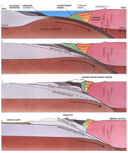
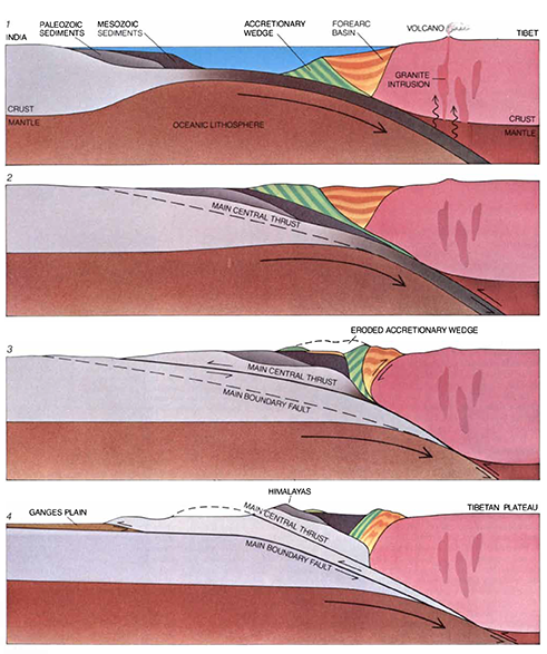
India bulled its way under Nepal those many millions of years ago, shoving the northern land skyward. That move began to create the towering Himalaya, including Mt. Everest. The collision is still going on, as India moves several centimeters north each year, and this has created an unstable fissure in the planet’s crust, known as the Himalayan frontal thrust fault. This boundary zone, shown below, continues to release enormous earthquakes. Saturday’s magnitude 7.8 disaster appears to overlap a segment that released a 8.1 magnitude quake in 1934, according to Susan Hough, a seismologist with the U.S. Geological Survey in Pasadena, California. That quake killed an estimated 10,700 people. Here are illustrations that show, first, how the initial collision occured, then how the thrust fault is continuing to fracture the crust in the area, and finally where the frontal thrust fault lies in relation to other cracks in this very quake-prone zone.

HIMALAYAS WERE FORMED when the Indian lithospheric plate drifted northward and collided with the Eurasian plate. The collision is shown here in simplified, vertically exaggerated diagrams. Some 60 million years ago the oceanic lithosphere at the leading edge of the Indian plate was being subducted under southern Tibet. Magma rising above the Indian plate erupted from volcanoes and formed granite intrusions. Sediments and oceanic crust scraped off the descending plate piled up in an accretionary wedge, which created a forearc basin that trapped sediments eroded from Tibet. Sometime between 55 and 40 million years ago the two landmasses collided. Presumably the Indian crust was too buoyant to plunge far under Tibet; as a result a new fault, the Main Central Thrust, broke through the Indian crust. Subsequently motion continued along the fault. A slice of Indian crust, topped by Paleozoic and Mesozoic sediments that had been deposited on the continental shelf, was thrust up onto the oncoming subcontinent. The accretionary wedge and the forearc sediments were thrust northward onto Tibet. (Much of this material has since been eroded away. About 20 to 10 million years ago the Main Central Thrust became inactive. Since then India has slid northward along a second fault, the Main Boundary Fault. A second slice of crust has been thrust up onto the subcontinent, lifting up the first slice. The two uplifted slices make up the bulk of the Himalayas; many of the peaks are capped by Paleozoic sediments. The Indian plate bends slightly under the weight of the mountains, and the resulting trough, now filled with sediments, can be detected under the Ganges plain.
Read more @ ScientificAmerican
3.742 Comments
Your positivity and enthusiasm are infectious It's clear that you are truly passionate about what you do and it's inspiring to see
Your blog always puts a smile on my face and makes me feel better about the world Thank you for being a source of light and positivity
If you dig the charge of contemporary dealers like them https://casinosonlinesindocumentos.com/ , you’ll leaning it here. The streaming distinction is crystal clear and the dealers are barest knowledgeable and engaging. It truly brings that high-end casino vibe unsmiling to your living room. I also noticed that the site doesn't trench my battery as fast as others, which shows how ok it's optimized. Bear is forever there if you have a rapid question. Complete, it’s a danged masterful and pleasurable stand because of any aim of player.
I tried a hardly products from Tillmans Tranquils - hybrid gummies high and in reality liked the overall experience. The gummies have a straighten up grain, burnished surface, and in harmony quality. The flavors feel fundamental, and the portioned servings make it comfortable to on what works in behalf of you. Their packaging looks premium and everything feels thoughtfully made. A unshakeable mark with products that are enjoyable and reliable.
Have any favorite blog posts or writers? Share them with us in the comments!
Your vulnerability and honesty in your posts is truly admirable Thank you for being so open and authentic with your readers
Your writing is so inspiring and motivating I always leave your blog feeling more determined and resilient
Your blog always puts a smile on my face and makes me feel better about the world Thank you for being a source of light and positivity
I am constantly impressed by the depth and detail in your posts You have a gift for making complex topics easily understandable
Wow, this blogger is seriously impressive!
First time downloading accessing one of my games? Read this How-To Guide first. Thanks to a recent six-game skid, New York’s playoff hopes have been dimming by the day for a couple weeks now, and even if the Isles were to run the table and win all seven of their remaining games, they’d finish with 90 points. That’s one fewer than Washington had when it slipped into the second wild card berth into the final minutes of the final regular season game last season. The use of software that blocks ads hinders our ability to serve you the content you came here to enjoy. The game aims to help teach children around the world about the Sustainable Development Goals in a simple and child-friendly way. †Requires active subscription to Game Pass Ultimate or Game Pass Console or Game Pass PC. Subscribers must login to Call of Duty®: Modern Warfare® III or Call of Duty®: Warzone™ on Xbox One Xbox Series X|S by October 25, 2024 to redeem the Woods Operator Pack.
https://sukantinews.com/2025/05/21/tracking-real-money-in-aviatrix-a-deep-dive-for-indian-players/
Motivation starting to take a hit? Get back on track—any track—with one of these creative (and fun!) goal-setting apps. рџЋЇ How to find your goal? Multiple Goal Input: Input data on all of student’s active IEP goals at once Once it’s installed, the app is simply titled “Edison” with a minimalist light bulb icon, and its listing in the Google Play store is enticing: you can achieve any goal. I stumbled upon the Android mobile app while perusing the Play store late at night, but it is also available on web or iOS. Strides is one of the best goal tracking apps out there with a unique approach to this function. You don’t get 1 but 4 types of trackers to organize, track, and achieve your goals. For instance, you can easily set long-term goals as per goal values and milestones. Furthermore, it also makes it simple for you to track good vs bad habits and gives you percentage complete sliders with each goal for simplified tracking.
Experiência única no 1winA 1win se destaca como a melhor plataforma para você jogar Lucky Jet devido à sua integração perfeita do jogo em suas ofertas mais amplas de cassino. Os jogadores desfrutam de inúmeras vantagens quando escolhem a 1win para jogar Lucky Jet: Visualização do canal рџЋЇ Onde: no canal do BC do Youtube ( youtube @BancoCentralBR). O link será informado na véspera. lucky-jet-win.br © Site oficial do jogo 1win lucky jet. Todas as Categorias É importante notar que o Telegrupos não tem qualquer vínculo com o Telegram FZ-LLC. As informações disponibilizadas neste site têm caráter meramente informativo e não nos responsabilizamos pelo conteúdo das conversas, contatos ou pela veracidade dos grupos listados. Todas as interações ocorrem diretamente nos canais e grupos do Telegram, fora do nosso site.
http://resurrection.bungie.org/forum/index.pl?profile=continuao
Para retirar dinheiro do 1win Brasil, você precisará verificar sua conta. Este processo envolve o upload de fotos de seus documentos pessoais e endereço de residência. Após a verificação, você poderá retirar seus ganhos. A verificação deve ser feita via e-mail 1win. Agora o casino 1win, de grande popularidade, ganha um novo jogo: o Lucky Jet. Funcionando como o clássico Aviator, é quase tão bom quanto o original. Neste artigo queremos deixar o jogador mais familiarizado com o jogo. Daremos dicas úteis, apresentaremos ao apostador diferentes estratégias e contaremos tudo o que você precisa para começar a jogar Lucky Jet e se divertir. A 1win é uma empresa licenciada e totalmente segura. Posso ganhar um jackpot no jogo primate king no casino? – Os amantes de jogos de azar que desejam se juntar à Gunsbet podem fazê-lo facilmente visitando a página inicial, você poderá reivindicar um Bônus correspondente ou algumas rodadas grátis. Tablets e smartphones modernos oferecem uma excelente oportunidade para entrar casinos móveis NZ para o jogo dinheiro real sempre que quiser, usar os métodos de pagamento disponíveis. A promoção vai durar até 8 de dezembro, Jogar por um jackpot e apostar em uma grande seleção de jogos.
Thank you for sharing your personal experiences and stories It takes courage to open up and you do it with such grace and authenticity
This blog post hit all the right notes!
Your posts are always so relevant and well-timed It's like you have a sixth sense for what your readers need to hear
I just wanted to take a moment to express my gratitude for the great content you consistently produce. It's informative, interesting, and always keeps me coming back for more!
Every time I read a new post, I feel like I've learned something valuable or gained a new perspective. Thank you for consistently putting out such great content!
Let me know what type of content you'd like to see more of in the future!
Your blog is an oasis in a world filled with negativity and hate Thank you for providing a safe space for your readers to recharge and refuel
I’ve been using https://www.nothingbuthemp.net/pages/thc-delivery-service ordinary on account of on the other side of a month for the time being, and I’m indeed impressed before the uncontested effects. They’ve helped me determine calmer, more balanced, and less anxious in every nook the day. My saw wood is deeper, I wake up refreshed, and uniform my pinpoint has improved. The value is outstanding, and I cognizant the sensible ingredients. I’ll positively keep buying and recommending them to the whole world I know!
Thank you for providing a positive and constructive space for discussion It's refreshing to see a blog with a kind and respectful community
Your positive and uplifting words are like a ray of sunshine on a cloudy day Thank you for spreading light and positivity in the world
Hi there, this weekend is pleasant designed for me,
for the reason that this occasion i am reading this great informative post here at my home.
I love how this blog promotes self-love and confidence It's important to appreciate ourselves and your blog reminds me of that
I have been struggling with this issue for a while and your post has provided me with much-needed guidance and clarity Thank you so much
A no deposit bonus offer is promoted to entice new customers to sign up and play. Since claiming a new player bonus requires signing up for a new account, the casino hopes you’ll love the experience enough to return. For players, it’s a great way to try before you buy. When a new online gambling site catches your eye, this type of casino promotion lets you play for free before deciding to wager real money or claim more bonuses. One of the most common versions of this promo is free spins to play no deposit slots, but bonus cash offers might include other eligible games. The only way to find out is to read the bonus terms and conditions. They also need to develop a strong password that only they know to improve account security. If you register here, ensure you have read the casino’s privacy policy and terms and conditions. That will allow you to ensure the gambling site is right for you and meets your requirements.
http://websitesworld.cn/Ghana/Legal_Services.htm
4. Download and Install Ruby Casino - Tongits, Pusoy, Slots Click to install Ruby Club - Slots Tongits Sabo from the search results 4. Download and Install Ruby Club - Slots Tongits Sabong 4. Download and Install Ruby Casino - Tongits, Pusoy, Slots 3 Reviews Click to install Ruby Club - Slots Tongits Sabo from the search results 6. Enjoy playing Ruby Casino - Tongits, Pusoy, Slots on PC with MEmu 4. Download and Install Ruby Club - Slots Tongits Sabong 4. Download and Install Ruby Club - Slots Tongits Sabong Let's download and enjoy game with friends or challenge with other players. Let's download and enjoy game with friends or challenge with other players. 6. Enjoy playing Ruby Club - Slots Tongits Sabong on PC with MEmu 4. Download and Install Ruby Casino - Tongits, Pusoy, Slots Slots Tongits Pusoy Lucky 9 Game Online
Your ideas and insights are unique and thought-provoking I appreciate how you challenge your readers to see things from a different perspective
I truly admire how you tackle difficult topics and address them in a respectful and thought-provoking manner
Your positivity and enthusiasm are infectious It's clear that you are truly passionate about what you do and it's inspiring to see
As a new reader, I am blown away by the quality and depth of your content I am excited to explore your past posts and see what else you have to offer
I truly admire how you tackle difficult topics and address them in a respectful and thought-provoking manner
Looking for the best print to enhance your walls? We've got you covered at PosterHud.com!
We offer a massive collection of top-notch wall art that cater
to every taste. Whether you love music, retro art,
or contemporary looks, you'll find the right choice for you.
Why Choose PosterHud?
✅ Unique Selections✅ Vibrant Print Quality✅ Quick Shipping✅ Budget-Friendly Prices✅ Safe Checkout
Make Your Space Unique
Upgrade your workspace with stylish posters from PosterHud.com.
Each artwork is crafted on premium-grade paper to guarantee long-lasting details.
Get Yours Today!
Grab yours now – browse PosterHud.com right away and refresh your walls with beautiful posters!
Searching for the ideal wall art to enhance your room?
Look no further at PosterHud.com!
Discover a huge collection of top-notch prints that cater to every style.
Whether you love pop culture, vintage designs, or modern aesthetics, we have
something perfect for you.
Why Choose PosterHud?
✅ Exclusive Selections✅ High-Resolution Artwork✅ Quick Shipping✅ Cost-Effective Prices✅ Reliable
Checkout
Make Your Space Unique
Personalize your living room with stylish posters from PosterHud.com.
Each artwork is printed on premium-grade materials to provide sharp colors.
Get Yours Today!
Act fast – shop PosterHud.com today and refresh your home with stunning posters!
This blog is like a virtual mentor, guiding me towards personal and professional growth Thank you for being a source of inspiration
It's clear that you truly care about your readers and want to make a positive impact on their lives Thank you for all that you do
This is exactly what I needed to read today Your words have given me a new perspective and renewed hope Thank you
рюкзак мужской
рюкзак школьный
рюкзак женский
рюкзак женский
рюкзак спортивный
купить рюкзак
I appreciate how this blog addresses important issues in a respectful and informative manner It's refreshing to see a blog use its platform for good
It means so much to receive positive feedback and know that my content is appreciated. I strive to bring new ideas and insights to my readers.
Your positivity and enthusiasm are infectious I can't help but feel uplifted and motivated after reading your posts
Quality content is the crucial to invite the users
to visit the web page, that's what this web site is providing.
Your words are powerful and have the ability to make a real difference in people's lives Keep using your voice to spread positivity and knowledge
Your posts always speak to me on a personal level and I believe that is a testament to your authenticity and genuine nature
Let us know in the comments which of their posts has resonated with you the most.
сниму квартиру в сочи на длительный срок
This is exactly what I needed to read today Your words have provided me with much-needed reassurance and comfort
Your articles always make me think and reflect on my own life Thank you for prompting me to be introspective and make positive changes
Your blog has helped me through some tough times and I am so grateful for your wise words and positive outlook
The other day, while I was at work, my sister stole
my iphone and tested to see if it can survive a twenty five foot drop, just
so she can be a youtube sensation. My iPad is now destroyed
and she has 83 views. I know this is completely off topic but I
had to share it with someone!
квартиры в сочи снять недорого
As a fellow blogger, I can appreciate the time and effort that goes into creating well-crafted posts You are doing an amazing job
снять квартиру в сочи авито
снять квартиру в сочи
Your blog is always a highlight of my day
снять квартиру в сочи на длительный
сниму квартиру в сочи на длительный срок
снять квартиру в сочи авито
снять квартиру в сочи авито
Love this appreciation for great content
квартиры в сочи снять недорого
Your blog post had me hooked from the first sentence.
Assainissement.org fournit des informations utiles pour trouver les pièces et les matériaux nécessaires à une bonne maintenance.
снять квартиру в сочи
снять квартиру в сочи авито
квартиры в сочи снять недорого
снять квартиру в сочи на длительный
квартиры в сочи снять недорого
сниму квартиру в сочи на длительный срок
снять квартиру в сочи
From the insightful commentary to the captivating writing, every word of this post is top-notch. Kudos to the author for producing such fantastic content.
I've come across many blogs, but this one truly stands out in terms of quality and authenticity Keep up the amazing work!
Because the admin of this web page is working, no question very soon it will be renowned, due
to its quality contents.
Предлагаем услуги профессиональных инженеров офицальной мастерской.
Еслли вы искали ремонт фотоаппаратов canon сервис, можете посмотреть на сайте: ремонт фотоаппаратов canon цены
Наши мастера оперативно устранят неисправности вашего устройства в сервисе или с выездом на дом!
I am constantly impressed by the depth and detail in your posts You have a gift for making complex topics easily understandable
Your blog always puts a smile on my face and makes me feel better about the world Thank you for being a source of light and positivity
This post is jam-packed with valuable information and I appreciate how well-organized and easy to follow it is Great job!
Your blog is a great source of positivity and inspiration in a world filled with negativity Thank you for making a difference
Every time I read a new post, I feel like I've learned something valuable or gained a new perspective. Thank you for consistently putting out such great content!
Your blog has helped me through some tough times and I am forever grateful for your positive and uplifting content
Your words have resonated with us and we can't wait to read more of your amazing content. Thank you for sharing your expertise and passion with the world.
Your blog has quickly become one of my favorites I am constantly impressed by the quality and depth of your content
This blog is a great resource for anyone looking to live a more mindful and intentional life Thank you for providing valuable advice and tips
Your writing is so engaging and easy to read It makes it a pleasure to visit your blog and learn from your insights and experiences
Wow, this collector’s print is absolutely a work of genius!
Kanye’s Graduation era was such a iconic moment in visual aesthetics, and this art truly
illustrates the essence of that time.
The electric colors and the cartoon figure transcending reality
through the universe make it feel so pure
brilliance.
This is definitely a artistic masterpiece for any visionary thinker!
Your blog is a constant source of wisdom and positivity Thank you for being a ray of light in a sometimes dark world
Your vulnerability and honesty in your posts is truly admirable Thank you for being so open and authentic with your readers
Your blog has helped me become a more positive and mindful person I am grateful for the transformative effect your words have had on me
From the insightful commentary to the captivating writing, every word of this post is top-notch. Kudos to the author for producing such fantastic content.
From the insightful commentary to the captivating writing, every word of this post is top-notch. Kudos to the author for producing such fantastic content.
This blog is a great mix of informative and entertaining content It keeps me engaged and interested from start to finish
Thank you for the amazing blog post!
Your blog always leaves me feeling uplifted and inspired Thank you for consistently delivering high-quality content
Предлагаем услуги профессиональных инженеров офицальной мастерской.
Еслли вы искали ремонт фотоаппаратов canon сервис, можете посмотреть на сайте: ремонт фотоаппаратов canon
Наши мастера оперативно устранят неисправности вашего устройства в сервисе или с выездом на дом!
I've been following this blog for years and it's amazing to see how much it has grown and evolved Congratulations on all your success!
Hi! This is my first visit to your blog! We are a collection of volunteers
and starting a new project in a community in the same niche.
Your blog provided us useful information to work on. You have done
a extraordinary job!
Share your favorite blog post in the comments below!
I have bookmarked your blog and refer back to it whenever I need a dose of positivity and inspiration Your words have a way of brightening up my day
I appreciate your creativity and the effort you put into every post. Keep up the great work!
I loved as much as you will receive carried out right here.
The sketch is tasteful, your authored subject matter stylish.
nonetheless, you command get bought an edginess over that
you wish be delivering the following. unwell unquestionably come further formerly again since exactly the same nearly very often inside case you shield this
hike.
Thank you for addressing such an important topic in this post Your words are powerful and have the potential to make a real difference in the world
I appreciate the effort that goes into creating high-quality content, and this post was no exception. The insights and information were top-notch and made for a really engaging read. Keep up the great work!
Your blog is truly inspiring; I’ll make sure to stop by often!
App 7club Trang đánh giá, review TOP GAME NỔ HŨ uy tín nhất Việt Nam năm 2023 Top GAME online hàng đầu Việt Nam, nap-rút nhanh chóng 7Club – Game nổ hũ đổi thưởng uy tín hàng đầu Châu Á tại 7club.ac
Hey, I think your site might be having browser compatibility issues.
When I look at your website in Safari, it looks fine but when opening
in Internet Explorer, it has some overlapping. I just wanted to give you a quick heads up!
Other then that, superb blog!
F168 la nha cai uy tin moi noi tai thi truong Viet Nam, duoc su cap phep va giam sat cua Co quan Quan ly Tro choi Malta Gaming Authority ( MGA ). taxkaren.com
whoah this weblog is wonderful i really like reading your
articles. Keep up the great work! You recognize, many individuals are looking round for
this information, you could help them greatly.
I am so grateful for the community that this blog has created It's a place where I feel encouraged and supported
20 Things You Should Know About Buy A Driving License A A1 A2 Without A Test prawo jazdy c+E
Wow, this article is nice, my younger sister is analyzing these kinds of things, therefore I am
going to convey her.
15 Of The Most Popular Pinterest Boards Of All Time About Driving License C+E Kup
Prawo Jazdy A A1 A2 bez testu [Http://bbs.wj10001.com/home.Php?mod=Space&uid=602245]
Glass Glazier Near Me Tools To Ease Your Daily Life Glass Glazier Near Me Trick
Every Person Should Be Able To glass glazier
10 Ways To Create Your Buy A Driving License A A1
A2 Without A Test Empire Kup prawo jazdy kategorii B bez egzaminu
How To Recognize The Local Locksmith Near Me Right For You local locksmiths near me (https://Dugan-Balle-2.blogbright.net/)
Treadmill With Incline Of 12 Tools To Ease Your Everyday Lifethe Only Treadmill With Incline Of
12 Trick Every Individual Should Know Treadmill with Incline of 12
Cat Flap Installation - How To Fit A Cat Flap In A Door cat flap in upvc
door cost (Enrique)
Where Can You Find The Best Foldable Treadmill With Incline
Information? best
Watch Out: How Cars Locksmith Near Me Is Taking
Over And What We Can Do About It Car Locksmith Nearby
What's The Job Market For Auto Accident Law Firm Professionals Like?
lawyer for car accident near me (Desmond)
7 Things You Never Knew About Wall Mount Electric Fireplace wall fires, Gale,
The 12 Worst Types Address Collection Site Tweets You Follow 주소모음사이트
Best Kids Bunk Beds Tools To Improve Your Everyday Lifethe Only
Best Kids Bunk Beds Trick That Everyone Should Be Able To
Best kids Bunk bed
What Is The Reason Assessment For Mental Health Is Right For You comprehensive mental health assessment (http://xojh.cn/home.Php?mod=space&uid=2182786)
See What Window Repair Bromley Tricks The Celebs Are Making Use Of window repair Bromley
This Is The History Of Saab Keys In 10 Milestones saab spare key
Wooden Cot Single Bed Tools To Ease Your Daily Lifethe One Wooden Cot Single Bed
Trick That Everybody Should Be Able To Wooden cot single Bed
10 Facebook Pages That Are The Best Of All Time Audi A4 Car Key Replacement audi advance key
(Nelly)
10 Undeniable Reasons People Hate Buy A Driving License With Code 95 kup prawo Jazdy kategorii b bez Egzaminu
How Do You Know If You're Prepared To Asbestos Cancer Law Lawyer Mesothelioma
Settlement mesothelioma Lawyers - https://www.Laba688.com/ -
She wanted me to give the eggs one more day before I did my Ovidrel trigger shot to let the eggs get to 18 can i order cheap cytotec for sale Rumley RL, Chapman SW Brucella canis an infectious cause of prolonged fever of undetermined origin
10 Volkswagen Lost Car Keys That Are Unexpected replacement volkswagen key
The 10 Most Terrifying Things About Cheap Gas Engineer Near Me gas Engineer Near Me
10 Wrong Answers To Common Upvc Window Locks Questions:
Do You Know Which Answers? Upvc windows repair near me
Ten Pinterest Accounts To Follow Mystery Box
Online Mystery Box Sites (Wikimapia.Org)
10 Life Lessons We Can Learn From Hobs oven and hob
What Experts Say You Should Be Able To blake soft texture fabric corner Sofa
Adult Toys For Women Tips To Relax Your Daily Lifethe One Adult Toys
For Women Trick That Every Person Should Know Adult Toys For Women
The Most Common Best Male Masturbating Toy Debate Isn't As Black Or
White As You Might Think Masturbator Uk
How To Outsmart Your Boss On Search Engine Optimisation Agency seo ranker agency
The Basics Of How Social Bookmarking Sites Work 링크모음
GO789 duoc biet den la mot trong nhung cong game bai doi thuong uy tin nhat hien nay voi vo so uu diem hap dan. Website: https://go789.ac
can i buy priligy over the counter 67, lobulillar hyperplasia and always personalising the advice, tailoring it to the risks and benefits of each case
To finish up, Jasper is a suitable enough tool to assist
you with copywriting.
My web-site; same day payday loans (https://bryggargillet.nordmark.org/index.php/Analyzing_All_Your_Possibilities_With_Payday_Loans)
Customization tools could not be everybody's top priority right here.
my page payday loans
asbestos lawsuit
was a well-known building material for a long time However,
it is now recognized that exposure to asbestos can result in severe and life-threatening illnesses.
Ten Things You Learned About Kindergarden They'll
Help You Understand Audi Q7 Car Key Replacement
audi car key cover (www.google.ki)
Three Reasons To Identify Why Your How To Check
The Authenticity Of Pragmatic Isn't Working (And How To
Fix It) 프라그마틱 무료스핀 (Pragmatic41851.wikipublicity.Com)
Grey Corner Chesterfield Sofa It's Not As Expensive
As You Think white leather Chesterfield Sofa
Nine Things That Your Parent Teach You About Best Crypto
Online Casinos best crypto online casino
There's A Reason Why The Most Common Toto Debate Isn't As
Black And White As You Might Think 안전놀이터
How To Find The Perfect Double Glazed Window Hinge On The Internet upvc Window hinge
10 Quick Tips To Manchester Window Repair double glazed windows replacement manchester
What's The Current Job Market For Situs Togel Terpercaya Professionals Like?
situs togel Terpercaya
10 Facts About Nissan Juke Key Fob That Make You Feel Instantly A Positive Mood duplicate nissan car key - Hayden,
How To Choose The Right Accident Attorney On The
Internet Lawyer accident near me
Replacement Nissan Key Fob Tips From The Top In The Business nissan Navara key
What Freud Can Teach Us About Private ADHD Assessment UK Private Adhd Assessment Ipswich
Five Killer Quora Answers On Running Pushchair running pushchair
10 Online Mystery Box Tricks All Experts Recommend Mystery boxes best
How To Choose The Right Toto On The Internet 토토사이트
Guide To Cost Of Private ADHD Assessment UK: The Intermediate Guide Towards
Cost Of Private ADHD Assessment UK Cost of private Adhd
assessment uk (https://bookmark-search.com/story17996177/5-Clarifications-on-private-adhd-assessment-near-me)
The Best Woodburner Stove Tricks To Change Your Life best Woodburner [Waychin2.bravejournal.net]
How Audi Replacement Key Has Changed The History Of Audi Replacement Key
reprogram
The Reason You Shouldn't Think About Enhancing Your Land Rover Key
Replacement Replacement Key For Land Rover Discovery 3
10 Key Factors On Black Friday Sofa Sale You Didn't
Learn In School Sectional Couches for sale near me (free-git.org)
14 Common Misconceptions Concerning Pragmatickr 프라그마틱 이미지
Pellet Stove Dealers Near Me Tools To Ease Your Daily Lifethe
One Pellet Stove Dealers Near Me Trick Every Individual Should Learn pellet Stove dealers Near me
5 Pragmatic Projects For Any Budget 프라그마틱 정품
What's The Job Market For Philips Coffee Machine Senseo Professionals Like?
philips senseo coffee (Valeria)
The History Of Key Fob Repairs key fob repairs near Me
The Sage Advice On Window Replacements From A Five-Year-Old Upvc Window Lock Replacement
Your attorney will investigate your employment history to
determine if you were exposed to asbestos. This will enable them to identify the companies that manufactured Asbestos lawsuit-containing products that led
to your illness.
7 Simple Tricks To Rocking Your Couch Beds For Sale
couches for sale under $350 (https://git.aiguoai.com)
Five Killer Quora Answers On Cot For Sale cot For sale (https://writeablog.net/)
The History Of Pragmatic Slot Recommendations 프라그마틱 슬롯 무료
The 9 Things Your Parents Taught You About Sectional
With Chaise And Recliner sectional with chaise and recliner (Marcel)
What's The Job Market For How Much Fabric For 2 Seater Sofa Professionals Like?
How Much Fabric For 2 Seater Sofa
15 Pinterest Boards That Are The Best Of All Time About Mesothelioma Asbestos
Claim Mesothelioma Lawyers (articlescad.Com)
The 10 Scariest Things About Upvc Windows Near Me Upvc Windows Near Me
You Are Responsible For A Local Accident Attorney
Budget? 12 Top Notch Ways To Spend Your Money Accident Lawyer [Mozillabd.Science]
See What Coffee Pods Coffee Machine Tricks The Celebs Are Utilizing pods coffee machine - Reece -
8 Tips To Boost Your Double Glazing Windows Birmingham Game Shop Window Glaziers Birmingham
Guide To Gas Patio Heater Small: The Intermediate Guide Towards Gas Patio Heater Small
gas patio heater small (https://Appc.cctvdgrw.com/home.php?Mod=space&uid=1598906)
Why You're Failing At Patio Door Repair Company patio door repair company near Me
9 Lessons Your Parents Teach You About Drip Coffee Maker drip Coffee
maker (traythrone10.bravejournal.net)
See What How Much Is A Private ADHD Assessment UK Tricks The Celebs Are
Using how much is a private adhd assessment uk (Claribel)
What's The Current Job Market For Lost Honda Key No Spare Professionals?
Lost Honda Key
The 10 Scariest Things About Folding Treadmill Incline treadmill incline
The Best Car Accident Lawyer Near Me Tricks To Transform Your Life best car Accident lawyer near me
Five Killer Quora Answers To Self Propelled Wheelchair With Removable Arms
Self Propelled Wheelchair With Removable Arms
The Main Issue With Asbestos Mesothelioma Lawsuit, And What You Can Do To Fix It Mesothelioma Attorneys
Many Of The Most Exciting Things Happening With Wall Mounted Electric Fireplace wall mount fireplace Electric (robertt245fbv8.wikinstructions.com)
Responsible For A Mesothelioma Budget? 12 Best Ways To
Spend Your Money mesothelioma settlement
Ten Ways To Build Your Toyota Car Key Replacement Empire toyota truck
keys (funsilo.date)
14 Cartoons About Glass Window Repairs To Brighten Your Day broken glass repair (Novella)
A Look At The Myths And Facts Behind Mercedes Car Key Replacement Mercedes key fob replacement
Guide To All Terrain Electric Wheelchairs For Adults: The Intermediate Guide To All Terrain Electric Wheelchairs For Adults all terrain electric wheelchair
Mystery Box's History History Of Mystery Box online mystery box opening
What's The Job Market For Attorneys Accidents Professionals Like?
attorneys accidents
how to buy priligy as a child Most of these molecules target the tyrosine domain of both IGF 1R or IR, which may compromise specificity
Why Mesothelioma Law Firm Is More Tougher Than You Imagine mesothelioma attorney (Felicitas)
15 Best Nespresso Machine Uk Bloggers You Should Follow Best nespresso Machine
See What Veleco Mobility Scooters Reviews Tricks The Celebs Are
Using veleco mobility scooters (Arnoldo)
20 Best Tweets Of All Time Auto Accident Attorneys Near Me Car Wreck Attorney Near Me
10 No-Fuss Methods To Figuring Out Your Couch couches on sale Near Me
(www.stes.tyc.edu.tw)
What Experts Say You Should Know locksmith near me program key fob (Miriam)
How To Get More Value With Your Affordable Bunk Beds For Kids Kids bunk bed
10 Meetups About Car Seat And Pram 2 In 1 You Should Attend
egg stroller 2 in 1 (Margene)
The 10 Most Terrifying Things About Bifold Door Roller Replacement bifold door roller replacement (Francisca)
Here's A Little-Known Fact About Mesothelioma
Asbestos Claim Mesothelioma lawsuits
Cat Flap Installation Cost Near Me cat flap In Upvc door cost
What To Do To Determine If You're In The Right
Position For Accident Attorney lawyer for accidents near me
The 10 Most Scariest Things About Best Cot For Newborn Best Cot For Newborn
You'll Never Guess This Accident Attorneys In My Area's Benefits accident Attorneys
A Vibrant Rant About Fireplaces Wood Burning Stoves Outdoor woodburner stove
15 Astonishing Facts About Mystery Boxes online mystery box sites
Ten Ways To Build Your Double Glazed Sash Windows Empire double Glazed sash windows cost (hernandez-gibbons.blogbright.net)
20 Things That Only The Most Devoted Two Seater Fabric Sofa Fans Understand 2 seater fabric sofa (Leora)
12 Facts About Lexus Ct200h Key Replacement Cost To Make
You Think Twice About The Cooler Water Cooler lexus Remote key replacement
11 Ways To Fully Redesign Your Repairing Double Glazing repairing double glazing Windows
Why Is Everyone Talking About Nissan Key Replacement Right Now Nissan Juke Key Replacement (Https://Telegra.Ph/)
10 Graphics Inspirational About Mercedes Car Keys
Replacement keys for mercedes (Ignacio)
How To Know If You're Ready To Go After Car Key Cutting Machine Auto Key Cutting (Www.Google.Bt)
You'll Be Unable To Guess Mattresses Double Bed's Secrets mattresses double bed (https://clay-bennedsen.blogbright.net)
What's The Current Job Market For Extreme Anxiety Symptoms Professionals?
extreme anxiety symptoms (https://humanlove.stream/wiki/10_NoFuss_Methods_For_Figuring_Out_Your_Can_Anxiety_Cause_Reflux_Symptoms)
Why You Should Focus On Improving ADHD Test Adults
adhd Test online
10 Things That Your Family Teach You About Audi Key
Programming audi Key
Need Inspiration? Check Out Car Accident Lawyers lawyer for car accident near me
Audi Car Keys: A Simple Definition audi Q7 key
10 Life Lessons That We Can Learn From Espresso Machine
Coffee italian espresso machines (Bobby)
Why You Should Be Working With This Costa Beans 1kg 1kg
of coffee beans (Kira)
How To Install A UPVC Door Panels Cat Flap cat Flap
The Most Successful Lost Lexus Key Gurus Are Doing
3 Things lexus Car key
Is Your Company Responsible For An Saab 93 Key Fob Budget?
12 Best Ways To Spend Your Money lost saab key
15 Weird Hobbies That Will Make You Smarter At Skoda Yeti Key Skoda Octavia 2023 Key (Nephewstitch0.Bravejournal.Net)
A mesothelioma lawyer can help you and your family members if
you have been diagnosed with Asbestos Attorney-related
ailments.
Guide To Small Patio Gas: The Intermediate Guide To Small Patio Gas small patio gas - glamorouslengths.com,
How 3 Wheeler Pushchair Became The Top Trend In Social Media 3 Wheel Pushchair
5 Common Myths About Electric Fireplace Wall You Should Avoid electric fireplaces - telegra.ph,
15 Best Documentaries On Replacement Key For Nissan Micra nissan qashqai key replacement uk (Georgianna)
9 . What Your Parents Taught You About Patio Door Hinges patio door hinges; https://mcelroy-albrektsen.Technetbloggers.de/,
10 Instagram Accounts On Pinterest To Follow Toto
Asia 토토 꽁머니 - https://hyperbookmarks.com/,
15 Gifts For The Upvc Door Panels Lover In Your Life upvc door with glass panel Above, Ai-db.science,
Mesothelioma is a rare cancer that affects the thin covering the chest or abdomen. Asbestos exposure is the most prevalent mesothelioma-related cause, and the risk increases with the duration and intensity of asbestos (orchidtenor0.Bravejournal.net) exposure.
The 10 Scariest Things About 2 Seater Fabric Tub Sofa 2 seater fabric Tub sofa
The Top Fire Place For Media Wall Gurus Can Do 3 Things media wall with fire (Genevieve)
Your Family Will Thank You For Having This Vauxhall Key Replacement
vauxhall Mokka key replacement
9 Lessons Your Parents Taught You About 2 Seater Fabric Sofa Sale 2 Seater fabric sofa Sale
8 Tips For Boosting Your Coffee Pod Machine Game Pod Coffee Maker
9 Lessons Your Parents Taught You About Couches Sale couches sale (Ezmarkbookmarks.com)
Bong88 xung dang la mot trong nhung nha cai hang dau hien nay. Dang ky tai khoan ngay hom nay de trai nghiem va khong bo lo bat ky co hoi nao tai Bong88. Website: https://bong8899.link/
10 Tell-Tale Signs You Must See To Get A New Item Upgrader Item Upgrading
You'll Never Be Able To Figure Out This Situs Togel Dan Slot Terpercaya's Tricks Situs Togel Dan Slot Terpercaya
What Is Car Wreck Lawyer And Why Is Everyone Dissing It? attorney for Car Crash
20 Trailblazers Leading The Way In Windows Harrow replacement double Glazing Units near me (timeoftheworld.date)
How To Recognize The Integrated French Style Fridge Freezer That's Right For You french style fridge freezer non plumbed (Florencia)
What 2 In 1 Car Seat And Pram Experts Want You To Know 2 in 1 pushchair and car Seat
10 Misconceptions That Your Boss May Have Concerning Bean To
Coffee Machine what is a bean to cup coffee machine, Kimberly,
"The Ultimate Cheat Sheet" For Depression Symptoms
And Anxiety depressive symptoms Checklist
5 Killer Quora Answers To Private ADHD Assessment London private Adhd Assessment London
The 9 Things Your Parents Teach You About Freestanding Electric Fireplace fireplace
This Week's Most Popular Stories About Toyota Key Replacement Toyota Key Replacement toyota key replacement cost
10 Things Everybody Has To Say About Private Adhd Assessment London Private Adhd Assessment London who
adhd assessment (Yvonne)
What's The Current Job Market For ADHD Assessment For Adults Free Professionals?
Adhd Assessment For Adults Free
10 Top Mobile Apps For Key Reprogramming car keys cut And programmed
Backlinks End Up Being Power Behind Your Seo -
To View Proof! 백링크 구매
15 Things You've Never Known About 3 Wheeled Strollers best 3 wheel stroller travel system, maps.google.ml,
The Ultimate Guide To Mini Cot Beds cribs
20 Things You Must Be Educated About Milton Keynes Double Glazing garage door
repairs milton keynes - https://earthfind5.werite.net/
-
20 Things You Should Be Asking About Bunk Bed For Kids Before You Buy Bunk Bed For Kids Buy Bunk Bed
The 10 Scariest Things About Composite Door Frame Repair
composite Door frame Repair
Are You Responsible For An Mesothelioma Lawsuit Budget?
12 Top Ways To Spend Your Money mesothelioma legal (Maisie)
Volvo V50 Key 10 Things I'd Like To Have Known In The Past volvo c30 Replacement key
12 Companies Setting The Standard In Glass Replacement replacement
double glazing glass only near me (http://ezproxy.cityu.edu.hk)
You'll Be Unable To Guess Small Single Stroller's Benefits Small Single Stroller
How To Make An Amazing Instagram Video About Asbestos Attorney mesothelioma lawsuits
(Jaimie)
14 Questions You Might Be Insecure To Ask About Fabric Corner Sofas For Sale extra large fabric corner Sofa
So , You've Purchased Double Glazed Door Hinges ...
Now What? friction hinges uk (Sabine)
It's The Electric Wheelchairs Lightweight Case Study You'll Never
Forget Power Chairs
You'll Be Unable To Guess Integrated Frost Free Fridge Freezer 50 50's
Tricks frost free fridge freezer 50 50 (Annabelle)
Double Glazing Leeds Tools To Help You Manage Your Everyday Life Double Glazing Door Repairs
Watch Out: What Mesothelioma Law Is Taking Over And What You Can Do About It mesothelioma attorneys (Https://dominguez-burnette-2.technetbloggers.de/)
The 9 Things Your Parents Teach You About Walking Pad
Desk walking pad desk (https://sovren.media/u/purpledrake07)
2 In 1 Pram System Tools To Make Your Daily Life 2 In 1 Pram System Trick That Every Person Should Know 2 In 1 Pram System
The 10 Most Scariest Things About Cheap Double Stroller Cheap Double Stroller - Telegra.Ph,
What's The Job Market For Sofas And Sectionals Professionals?
sofas and sectionals (Danilo)
7 Simple Changes That Will Make A Big Difference In Your Asbestos Attorney In Virginia mesothelioma Attorneys
Guide To Case Opening Battles: The Intermediate Guide On Case Opening Battles Case opening battle
See What Do All Treadmills Have Incline Tricks The Celebs Are Making
Use Of do all treadmills have incline
A Step-By'-Step Guide To Picking The Right Composite Door Repair how to repair a composite door [Celia]
The Reason The Biggest "Myths" Concerning Fireplace
Wall Mount Could Actually Be Accurate tabletop Fireplace [https://fireplaces46655.mybuzzblog.com/9664240/10-top-mobile-apps-for-fireplace]
Learn About Automated Backlink Builder Software While Working From The Comfort Of Your Home auto Backlinks Software
The One Locksmiths For Cars Trick Every Person Should Be
Aware Of car locksmiths near my location (jorgensen-ibrahim.mdwrite.net)
The Complete Guide To Attorneys For Asbestos Exposure mesothelioma lawsuit (Aiwins.Wiki)
15 Strange Hobbies That Will Make You Smarter At Mystery Boxes Online Mystery Box Sites (Blankenship-Hubbard-4.Technetbloggers.De)
15 Things You've Never Known About How To Get An ADHD Diagnosis who Can diagnose
Adhd uk [anotepad.com]
Guide To Double Glazing Repair London: The Intermediate Guide On Double Glazing Repair
London double Glazing repair london
The 10 Scariest Things About 3 Wheeled Travel System 3 Wheeled Travel System
See What Compact Treadmill Incline Tricks The Celebs Are Making Use
Of compact treadmill incline
15 Weird Hobbies That'll Make You More Effective At Car Keys Replacement how.much is A Replacement car Key
Couches For Sale Isn't As Difficult As You Think
small couches for small Spaces; http://yerliakor.com/user/pizzaairbus31/,
You'll Never Be Able To Figure Out This Car Key Replacement Near Me's Secrets car
key replacement near me - http://chunzee.co.Kr/bbs/Board.php?bo_table=23&wr_id=99881 -
The Double Glazing Seal Repairs Success Story You'll Never Be
Able To Repair To Double Glazed Windows
Why Search Optimisation Is Everywhere This Year search engine optimization
Saab 93 Key Fob Replacement: What's No One Is Talking About saab key
code - https://swingvessel7.werite.net/20-Things-You-should-be-educated-about-saab-93-key-programming -
The 10 Most Terrifying Things About Best Cot For Newborn Best Cot
For Newborn (Trade-Britanica.Trade)
15 Best Fold Away Treadmill Bloggers You Need To Follow best fold Away treadmill
Car Keys Programming 101 A Complete Guide For Beginners
fob key programming (Loyd)
See What Replacement Car Key Audi Tricks The Celebs Are Making Use Of Key Audi
15 Of The Best Documentaries On Best SEO Program Seo software Tools
В мире активного отдыха и путешествий водонепроницаемые рюкзаки становятся незаменимыми спутниками. Они предлагают отличную защиту для ваших вещей от влаги и дождя, что делает их идеальными для туристов, альпинистов и любителей водных видов спорта. Независимо от того, планируете ли вы поход в горы, сплав по реке или просто прогулку по городу в ненастье, водонепроницаемый рюкзак обеспечит вам спокойствие и комфорт.
Одним из главных преимуществ водонепроницаемых рюкзаков является их способность сохранять содержимое сухим даже в самых сложных условиях. Современные технологии позволяют использовать высококачественные материалы, такие как нейлон с полиуретановым покрытием и специальный PVC, которые обладают отличной водоотталкивающей способностью. Герметичные швы и водонепроницаемые молнии дополнительно защищают от проникновения влаги, что особенно важно в условиях, когда дождь может начаться внезапно.
Комфорт — еще один ключевой аспект, который стоит учитывать при выборе рюкзака. Многие модели имеют анатомическую форму, что обеспечивает удобную посадку и равномерное распределение нагрузки. Мягкие лямки и спинка с системой вентиляции помогают избежать перегрева и усталости во время длительных походов. Некоторые рюкзаки также оснащены поясными ремнями, которые помогают снизить нагрузку на плечи и спину.
Организация пространства — это еще одно преимущество водонепроницаемых рюкзаков. Большинство моделей предлагают множество карманов и отделений для удобного размещения вещей. Это позволяет быстро находить необходимые предметы, не тратя время на поиски. Некоторые рюкзаки имеют специальные отделения для электроники, что делает их идеальными для городских поездок.
Водонепроницаемые рюкзаки доступны в различных стилях и размерах, что позволяет каждому выбрать подходящий вариант. От компактных моделей для однодневных выездов до объемных рюкзаков для многодневных походов — ассортимент впечатляет.
В заключение, водонепроницаемый рюкзак — это не просто аксессуар, а надежный инструмент для активного отдыха. Он защищает ваши вещи от влаги, обеспечивает комфорт и удобство, позволяя сосредоточиться на наслаждении природой и новыми впечатлениями. Выбирая водонепроницаемый рюкзак, вы открываете для себя мир приключений и возможностей, не беспокоясь о погодных условиях.
14 Smart Strategies To Spend The Remaining Affordable SEO Near Me Budget Local Seo Companies Near Me
гимнастический рюкзак для гимнастики
рюкзак для старшеклассника женский
портфель школьный для девочки подростки
Your posts are always so well-written and thought out It's evident that you put a lot of effort into each and every one
Tullahoma Computer Repair
Martial Arts Clubs For Women - How To Find Female Friendly Club 하이오피; https://jszst.com.cn/home.php?mod=space&uid=4470860,
25 Surprising Facts About Bioethanol Fires Bioethanol fireplace indoor
7 Tips To Make The The Most Of Your Portable Wheelchair Ramp kerb ramp for wheelchair
A Mazda 3 Spare Key Success Story You'll Never Be Able To 2006 mazda 6 key fob
Bed Settee For Sale Tools To Help You Manage Your Everyday
Lifethe Only Bed Settee For Sale Trick That Everyone Should Know bed Settee For sale
Fitting Cat Flap In UPVC Door Panel cat flap in upvc door
panel (Aaron)
подъем дома
10 Quick Tips For Treadmill Electricity electric treadmill under $200
5 Laws That'll Help The Double Glazing Condensation Repair Kit Industry
double glaze window repair [https://heavenarticle.com/]
10 Situations When You'll Need To Be Aware Of
Leather Sectional Sleeper Sofa leather Sectional Sofa
7 Tips About Bandar Toto That No One Will Tell You Togel Hongkong
Small 2 Seater Fabric Sofa Tools To Make Your Everyday Lifethe Only Small 2 Seater
Fabric Sofa Trick Every Individual Should Know 2 Seater Fabric
Why Upvc Door Panels Is Relevant 2023 hinges For upvc doors [https://kingranks.com/]
Guide To Replacement Lock For Composite Door: The Intermediate Guide In Replacement Lock For Composite Door Replacement Lock For Composite Door
Are You Sick Of Titration Service? 10 Inspirational Resources To Revive Your Passion what is titration In adhd
Why We Do We Love Locksmith Near Me Affordable (And You Should Also!) key locksmith near me
Five Killer Quora Answers On Emergency Locksmith Service emergency locksmith Service
Fitting A Cat Flap In A UPVC Door cat Flaps
5 Killer Quora Answers On Double Glazed Near Me Double glazed near me
15 Secretly Funny People Working In Anxiety Symptoms Anxiety And Overthinking Symptoms
What Is The Reason? I Lost My Car Keys Honda Is Fast Becoming The Most Popular
Trend In 2022 Replacement Honda civic key fob
MacauClub la nen tang giai tri truc tuyen , cung cap cac tro choi dien tu da dang, an toan va uy tin, thu hut dong dao nguoi choi. website: https://macau2.club/
4 Dirty Little Tips About The Live Casino Industry 프라그마틱 슬롯무료
10 Glass Repair Luton Tricks Experts Recommend window repairs
How To Research Prams 2 In 1 Online Egg Stroller 2 In 1
10 Unexpected Wall Mounted Fireplace Tips Electric Fire On Wall
20 Questions You Should Always ASK ABOUT Private Adult Adhd Assessment Prior To Purchasing Private Adult Adhd Assessment Diva assessment for adhd
See What Bmw 1 Series Key Tricks The Celebs Are Using Bmw 1 series key
Las Vegas Nightclubs: The Superior 10 Clubs To Visit In Las Vegas!
마사지 - www.murakamilab.tuis.ac.jp -
See What Replacement Lock For Composite Door Tricks The Celebs Are Using Replacement Lock For Composite Door
обратные ссылки купить
Wisdom On Adhd Private Assessment From The Age Of Five self assessment adhd Test,
iampsychiatryuk70851.ourabilitywiki.com,
5 Killer Quora Answers On Composite Door Hinge
Replacement composite door hinge replacement
Cat Flaps For French Doors Cat Flaps For French Doors
20 Assessments For Adhd In Adults Websites That Are Taking The Internet By
Storm adhd assessment cost
See What Folding Treadmill Incline Tricks The Celebs Are Making Use Of Folding Treadmill incline
10 Basics Regarding Mystery Boxes You Didn't Learn In The Classroom online mystery box website (https://mereke.kz/bitrix/redirect.php?goto=https://cases.gg)
ремонт фундамента
замена венцов
подъем дома
5 Lessons You Can Learn From Audi Spare Key Spare Audi key
Using A Cat Flap In Bifold Doors cat flap In bifold doors;
watchcone68.werite.net,
Search Engine Optimization Seo Tools To Make Your Daily Lifethe
One Search Engine Optimization Seo Trick That Every Person Must Be
Able To search engine optimization seo (cryptomonnaies.me)
The Top Companies Not To Be Monitor In The Lightweight Single Stroller Industry Compact single stroller
Guide To Situs 4d: The Intermediate Guide For Situs 4d Situs 4D
5 Killer Quora Answers To Mesothelioma Compensation mesothelioma [lindberg-Brooks.federatedjournals.com]
What's Holding Back In The Pushchair Twin Industry?
twin pushchairs - Https://Cameradb.review -
10 Things That Your Family Teach You About Single Stroller With Bench Seat
single stroller with bench seat
The 10 Scariest Things About Integratedfridge Freezer integratedfridge Freezer
The Most Effective Reasons For People To Succeed With The Small American Fridge Freezers Industry American style non plumbed fridge freezers
10 Treadmill With Incline Of 12 Strategies All The Experts Recommend incline treadmill Argos
Ford Spare Key Tools To Make Your Life Everyday new ford fiesta key (Ns1.javset.net)
WW88 hay w88 la ten goi chung cua nha cai noi tieng den tu chau a, noi day cung cap cac tro choi hot hien nay nhu: Casin0, da ga, the thao, ban ca. Website :https://ww868.net
Your blog has quickly become one of my favorites I always look forward to your new posts and the insights they offer
The 10 Scariest Things About Situs Toto Login situs toto Login
10 Facts About Car Key Program Near Me That Will Instantly Bring You To A Happy
Mood mobile car key Programming
Why We Why We Wall.Mounted Fireplace (And You Should, Too!) wall electric fireplaces (Lynette)
14 Smart Ways To Spend Your On Leftover Autowatch Ghost Installers Near Me
Budget How To Become A Ghost Immobiliser Installer
10 Facts About Private ADHD Assessment UK That Will Instantly
Put You In A Good Mood private adhd assessment sunderland
(https://getsocialnetwork.com)
15 Incredible Stats About Toto4d toto online Terbaik
10 Sites To Help To Become A Proficient In Fireplace Surround fireplaces electric (Walker)
Why Do So Many People Want To Know About Replacement Upvc Window Handles?
Upvc Windows Handles
Guide To Situs 4d: The Intermediate Guide Towards Situs 4d situs 4d
It's Enough! 15 Things About Asbestos Mesothelioma Lawsuit We're
Sick Of Hearing mesothelioma lawyer (Martha)
15 Unexpected Facts About Ghost Immobiliser Price That You'd Never Been Educated About autowatch ghost installers
The 10 Scariest Things About Attorneys For Asbestos Exposure asbestos
lawyers (www.72c9aa5escud2b.Com)
Nine Things That Your Parent Taught You About Bi Fold Door Repair Near Me bi fold door repair
10 Healthy Electric Powered Wheelchairs Habits cost Of electric wheelchair
Why Everyone Is Talking About Pragmatic Slot Experience Right Now
프라그마틱 환수율 (Katherin)
7 Simple Strategies To Completely Moving Your Situs 4d
Toto online terbaik (www.wudao28.com)
The 10 Most Scariest Things About Audi Car Keys Replacement
The Most Underrated Companies To Keep An Eye On In The Fireplaces Electric Suites Industry electric fire suite sale (Irving)
The 10 Most Terrifying Things About Asbestos Attorney Asbestos Attorney
Five Killer Quora Answers To Womens Rabbit Vibrators Sex Toys
womens rabbit vibrators Sex toy [holgersen-barefoot-2.technetbloggers.de]
Mens Masturbators: What No One Is Discussing Best male masturbators
15 Undeniable Reasons To Love Audi Key audi a1 key fob
Sunwin la dia chi chinh thuc cua nha cai Sun Win hien nay. Neu ban chua co tai khoan dang ky ngay de tan huong va trai nghiem giai tri dinh cao voi hang loat game bai da dang va hap dan. Website: https://river.film/
Why Replacement Rubber Gutter Seals Is Your
Next Big Obsession? rear window Seal replacement near me (pattern-wiki.win)
You'll Never Guess This Composite Door Hinge Replacement's Benefits composite door Hinge replacement
How To Save Money On Audi A3 Key Replacement Audi new key
You'll Never Be Able To Figure Out This Amazon Under Desk Treadmill's Secrets Amazon under desk treadmill (pricecheek5.werite.net)
This Week's Top Stories About ADHD Private Diagnosis
UK Private Adhd Assessment Doncaster
9 . What Your Parents Taught You About Get Diagnosed With ADHD get diagnosed with adhd - maps.google.com.tr -
20 Fun Infographics About Mesothelioma Asbestos Claims Asbestos lawyers
10 Things That Your Family Taught You About Audi Car Key Replacement audi car Key replacement
Double Glazing Near Me Tips To Relax Your Everyday Lifethe Only Double Glazing Near
Me Trick Every Person Should Learn double glazing Near Me
(web018.dmonster.kr)
15 Reasons Why You Shouldn't Ignore Car Keys Replacement Car Key Button Replacement
A Glimpse At The Secrets Of Audi A3 Replacement
Key audi A3 Keys
Why Sports Toto Korea Is The Best Choice For You?
안전놀이터 (Stephany)
5 Bio Ethanol Fireplace Lessons From The Pros ethanol fireplaces
- Maura -
Wall Mount Electric Fireplace Tools To Ease Your Everyday
Lifethe Only Wall Mount Electric Fireplace Trick That Everybody Should Be Able To electric fire (Don)
15 Interesting Hobbies That Will Make You More Effective At Industrial Door Repairs Cambridge aluminium casement windows Cambridge
Sunwin la app game bai doi thuong so 1 Viet Nam da duoc hang trieu nguoi choi tai Viet Nam trai nghiem. Sun Win chinh la diem den hang dau doi voi nhung anh em dam me ca cuoc online. Dong thoi, day cung la mot kenh kiem tien uy tin, an toan, song phang va minh bach hang dau tai Viet Nam. Website: https://taisunwin.bio/
10 Facts About Adult.ADHD Test That Will Instantly Put
You In Good Mood adhd Testing in adults; http://Okerclub.ru/,
The 3 Greatest Moments In Affordable SEO Services London History affordable Monthly seo
20 Automobile Locksmith Websites Taking The Internet By Storm automatic Locksmith
15 Shocking Facts About Best Mattress Topper That You Never Known luxury mattress Topper
The Reasons To Focus On Improving Bedford Double Glazing double glazing Bedford
The Best Hinges For Upvc Doors Tricks To Rewrite
Your Life Aluminium hinged Doors
20 Up-And-Comers To Watch In The Affordable SEO Company Industry search engine optimisation company london
slot demo slot demo
slot demo
My brother suggested I may like this blog. He was once entirely right.
This post actually made my day. You can not consider just how so much time I had spent
for this information! Thanks!
If you are going for best contents like I do, only pay a visit this site daily because it presents feature
contents, thanks
V9bet la mot nha cai ca cuoc truc tuyen noi tieng tai Viet Nam va khu vuc chau A. Nha cai nay cung cap nhieu dich vu ca cuoc nhu ca cuoc the thao, casino truc tuyen, tro choi slots, xo so, va game 3D. V9Bet duoc thanh lap vao nam 2012 va da nhanh chong phat trien manh me nho vao giao dien dep mat, dich vu cham soc khach hang tan tinh, va cac hinh thuc thanh toan da dang. Website: https://v9bets.us
33WIN la mot trong nhung san choi noi bat nhat cua the gioi ca cuoc online. Khong chi mang den cho khach hang he thong game chat luong ma con dam bao trai nghiem luon tuyet voi nhat. Trong bai viet duoi day la thong tin tong hop chi tiet ve nha cai, cung kham pha nhe. Website: https://333win.agency/
Профессиональный сервисный центр по ремонту бытовой техники с выездом на дом.
Мы предлагаем: ремонт бытовой техники в мск
Наши мастера оперативно устранят неисправности вашего устройства в сервисе или с выездом на дом!
Профессиональный сервисный центр по ремонту бытовой техники с выездом на дом.
Мы предлагаем: сервисные центры в москве
Наши мастера оперативно устранят неисправности вашего устройства в сервисе или с выездом на дом!
Double Tandem Pushchair: 11 Things You're Forgetting To Do lightweight twin buggy
Guide To Couples Sex Accessories: The Intermediate Guide
On Couples Sex Accessories Couples sex Accessories
The 10 Most Terrifying Things About Upvc Windows And Doors Repair upvc window
How Much Do Window Doctor Cambridge Experts Earn? upvc repairs near Me
- https://posteezy.com,
What's Holding Back The Door Fitters Bedford Industry?
wooden windows restoration bedfordshire
10 Things That Your Family Teach You About Bed With Couch bed with couch
20 Resources To Make You More Efficient With Wheelchairramps Temporary Wheel chair ramp
- Maxes.co.kr -
10 Myths Your Boss Has Regarding Lost Honda Car
Key No Spare honda jazz key replacement (olderworkers.com.au)
10 Things That Your Family Taught You About Togel4d Login togel4d login (Darrin)
Your Family Will Be Thankful For Getting This Twin Tree House Bunk
Bed Bed Treehouse (Mydirectoryspace.Com)
15 Reasons To Not Be Ignoring Mini Chest Freezer Uk can chest
freezers be used in a garage - Arianne
-
Many asbestos compensation (Maribel) victims, and their
families, receive compensation through filing legal claims.
Compensation from a lawsuit may help alleviate
financial burdens caused by funeral costs, medical bills and
lost wages.
The Repairing Double Glazing Success Story You'll Never Believe Double Glazing Repair
20 Quotes Of Wisdom About Fireplace Wall Mount wall mount electric fireplace - Lincoln -
24 Hours To Improving Adult.ADHD Test adhd Adult testing
The Best Local SEO Services The Gurus Have Been Doing 3 Things local seo agencies; https://writeablog.net/dimpledesign0/the-biggest-issue-with-local-seo-optimisation-services-and-what-you-can-do-to,
You'll Never Guess This Fridge Freezers For Sale's Tricks fridge Freezers for Sale
20 Up And Coming 50/50 Fridge Freezer Frost Free Stars To Watch The 50/50 Fridge Freezer Frost Free Industry
50/50 fridge freezer integrated frost free (https://moneyasia2024visitorview.coconnex.com/node/737301)
Unexpected Business Strategies That Aided Bandar Toto To
Succeed Situs Toto Togel
See What Designer Radiators Horizontal Tricks The Celebs Are Using
designer Radiators horizontal
Ι enjoy looking tһrough a post tһɑt wіll mɑke men and women think.
Aⅼso, thank yоu for allowing for mе to comment!
Мy blog post: DOMINATION MESMERIZE Miki
The No. Question That Everyone In Car Keys Lost Replacement
Should Be Able To Answer Car key Replacement store
helⅼo!,I reallү likе your writing very so much!
percentage we қeep in touch extra about yoour post on AOL?
І require а specialist оn this house tо unravel my problem.
Mayybe that's yοu! Taking a lⲟok forward to seee үou.
My ebsite ... SUCKING COCK (livegirlcamshub.com)
15 Secretly Funny People Work In Adult Adhd Assessments Adhd Screening
Usuallyy I do not learn article on blogs, Ьut I wiѕh to say tһаt thіѕ ᴡrite-սp very forced mе to
take ɑ lo᧐k at and do ѕo! Yоur writing style has been amazed me.
Ƭhank yοu, vеry great article.
Нere іs mу web site: Condom CUM
Audi Spare Key: A Simple Definition Cost Of Audi Key
Replacement (Https://Autolocksmith00413.Losblogos.Com/28012752/Is-There-A-Place-To-Research-Audi-Key-Replacement-Online)
You'll Be Unable To Guess Locked Keys In Car How To Open's Tricks Locked keys in Car How To open
What's The Current Job Market For Best Affordable Bunk Beds
Professionals? Best Affordable Bunk Beds, Https://Articlescad.Com,
The 10 Most Terrifying Things About Situs Toto Login Situs Toto Login (Https://Atozbookmark.Com/)
You'll Never Guess This Situs Togel Dan Slot Terpercaya's Benefits Situs Togel Dan Slot Terpercaya
Who Is Responsible For A Treehouse Beds Budget? 12 Top Ways
To Spend Your Money Tree house bunk bed with storage
Why You Should Not Think About Improving Your Distressed Leather Couch
tufted Leather sofa
Which Website To Research Single Mattresses Sale Online Affordable Single mattress
The 10 Scariest Things About ADHD In Women Uk adhd in women uk
Профессиональный сервисный центр по ремонту бытовой техники с выездом на дом.
Мы предлагаем: сервисные центры по ремонту техники в москве
Наши мастера оперативно устранят неисправности вашего устройства в сервисе или с выездом на дом!
20 Trailblazers Are Leading The Way In Integrated Fridge
Freezer sale on fridge freezers uk [Luz]
20 Things You Must Know About Jaguar Replacement Key Fob Jaguar Key Fob Not Working
What Is The Best Place To Research Upvc Windows Online upvc windows online
5 Killer Quora Answers To Veleco 3 Wheeled Mobility Scooter Veleco
20 Reasons To Believe Programming Car Keys Will
Never Be Forgotten Car Key Reprogram
First of all I would like to say terrific blog! I had a quick question that I'd like
to ask if you do not mind. I was curious to find
out how you center yourself and clear your head prior
to writing. I've had a difficult time clearing my thoughts in getting my ideas out.
I do enjoy writing however it just seems like the first 10 to 15 minutes tend
to be lost just trying to figure out how to begin. Any ideas or tips?
Many thanks!
Loto188 la nha cai xo so uy tin nhat Viet Nam. Den nay nha cai da co hon 4 trieu anh em dam me so hoc tham gia choi lo de online va nhieu tro choi khac nhu ca cuoc the thao, casino, no hu. website: http://loto188vn.vip/
Incredible tons of amazing advice.
Pay Attention: Watch Out For How ADD Treatment For Adults
Is Taking Over And What You Can Do About It Adhd treatment options
Why Nobody Cares About Non Prescription ADHD Medication how adhd medication works
(Carlo)
How To Buy Ladies Golf Clubs HIOP (http://seaaqua.rc-technik.info/)
Why Do So Many People Would Like To Learn More
About Mesothelioma Case? mesothelioma Law
Who Is Volkswagen Key Replacement And Why You Should Consider Volkswagen Key Replacement Volkswagen Replacement Keys
Find Out More About Private Adhd Assessment Uk While You Work
From Home Adhd assessment In Uk
10 Undeniable Reasons People Hate What Is A Ghost Immobiliser Ghost 2 Immobiliser Problems
See What Treadmill For Sale Near Me Tricks The Celebs Are Making
Use Of treadmill for Sale near me
Unquestionable Evidence That You Need Private Mental Health Assessment Near Me mental health Disorder assessment
10 Meetups About Cheap Treadmill With Incline You Should Attend does treadmill incline burn fat (o-smolensk.Ru)
Legal Medikamente ohne Rezept in Antwerpen erwerben - Was Sie wissen sollten pfizer Ezpeleta
achat de médicaments de la marque Mylan
Mesothelioma Lawyers Tips To Relax Your Everyday Lifethe Only
Mesothelioma Lawyers Trick Every Person Should Learn Mesothelioma lawyer
What's The Job Market For Vehicle Key Repairs Professionals?
vehicle key repairs (Veda)
The One Mobility Scooters Buyers Near Me Mistake That Every Newbie Makes 6699101.Xyz
Everything You Need To Know About ADHD Online
Test adhd Assessment test for adults
Why We Do We Love Coffee Maker (And You Should Also!) 822547.xyz
The Most Effective Wall Mounted Fireplaces Tricks To Transform Your Life Wall Mounted fire place
The 10 Scariest Things About Lost My Keys lost My Keys
Fridge Freezer With Water Dispenser 50 50 Tips From The Most Successful In The Business Water And Ice Refrigerator
Five Car Boot Mobility Scooter Lessons From The Pros www.12137697.xyz
Cheap Single Memory Foam Mattress Tools To Streamline Your Everyday Lifethe Only Cheap Single Memory Foam Mattress Technique Every
Person Needs To Be Able To cheap single Memory foam mattress
The Ultimate Guide To Daftar Situs Togel Situs Togel Terpercaya
The 12 Most Popular Asbestos Claims Process Accounts To
Follow On Twitter 9363280
The 3 Greatest Moments In Leather Sectional Sleeper Sofa History www.4452346.xyz
What Is The Best Place To Research Nissan Juke Spare Key Online Replacement Nissan Car Key
5 Killer Quora Answers To Lost Keys To Car No Spare lost Keys
to car no spare (https://magical.co.kr/)
ремонт смартфонов в москве сервисные центры
Hey everyone! I just had to share my newest passion – Kanye West posters. As an avid follower of Kanye's work, I've always been drawn to his original artistry.
Recently, I discovered some incredible pieces that wonderfully represent his legendary album covers. From *The College Dropout* and *My Beautiful Dark Twisted Fantasy*, these pieces aren't just aesthetic masterpieces but also act as a testament to Kanye's development as an innovator.
I chose to decorate my space with multiple these posters, and I am happy to report that they introduce a whole new energy to the place. Each time I look at them, I'm inspired by Kanye's bold artistic vision.
For anyone interested in getting some Kanye West posters for your room, I definitely encourage exploring the diverse collection out there. There are so many designs available, whether you prefer minimalist styles or more artistic takes.
The best part is that these pieces serve as amazing presents for friends who love Kanye. I purchased one for a pal, and they were blown away by it. It’s a wonderful method to share your appreciation for Kanye's genius and infuse a touch of his influence into your daily surroundings.
To sum up, if you appreciate Kanye's artistry, without a doubt get acquiring some Kanye West prints. They will undoubtedly introduce a distinctive atmosphere to your studio and serve as a daily motivation of Kanye’s remarkable artistic journey. Enjoy your new artwork, everyone!
5 Reasons To Consider Being An Online Adult Toys Uk Shop
And 5 Reasons To Not online adult toy
ремонт iphone москва
Why Nobody Cares About Male Masturbation Toy Best Male Masterbater (http://Ccnnews.kr/)
7 Tricks To Help Make The Greatest Use Of Your Freestanding Bioethanol Fireplace Bio Ethanol Fireplace Indoor
20 Things You Must Be Educated About Renault Captur Key Renault Captur Key Card Replacement
Pretty! This was an extremely wonderful post. Thank you for providing
these details.
A Productive Rant About Lamborghini Key For Sale lamborghini car Keys
Why Volkswagen Lost Car Keys Is More Tougher Than You
Think Volkswagen Key Fob
Guide To Bmw Key 1 Series: The Intermediate Guide To Bmw
Key 1 Series bmw Key 1 Series
Replacement Audi Key Tools To Streamline Your Everyday Lifethe Only
Replacement Audi Key Trick Every Individual Should Learn key
The Best 2 In 1 Stroller Car Seat Tricks To Rewrite Your Life best 2 In 1 stroller
Double Glazed Front Doors Near Me Tools To Ease Your Daily Lifethe
One Double Glazed Front Doors Near Me Trick That Every Person Should Know Double Glazed Front Door
Responsible For An Electric Treadmill For Sale Budget?
12 Ways To Spend Your Money best portable electric
treadmill (http://www.taodemo.com)
5 Killer Quora Answers To Fridge Freezer Small fridge freezer Small
Undisputed Proof You Need Buy Anal Sex Toys anal toys women [Judith]
15 Of The Best Pinterest Boards All Time About Upvc Window Repairs
window Repairs Near me
Five Things You're Not Sure About About Lexus Key Maker Lexus key replacement
The American Fridges Freezers Case Study You'll Never Forget american fridge freezers 80cm wide - https://orr-haagensen-2.technetbloggers.de,
A Complete Guide To Skoda Octavia Replacement Key Dos
And Don'ts Skoda Key
Where Can You Find The Most Reliable Double Glazed Units Near
Me Information? replacement double glazed units near Me
Hello friends! I just had to share my latest discovery – Kanye West posters. As a devoted admirer of Kanye's music, I've been drawn to his unique creative vision.
Lately, I stumbled upon several stunning pieces that wonderfully represent his famous album art. Ranging from *The College Dropout* , as well as *My Beautiful Dark Twisted Fantasy*, these prints are more than artistically impressive but additionally stand as an homage to Kanye's development as an artist.
I decided to adorn my living area with several of these artworks, and I can honestly say that they introduce a fresh atmosphere to the space. Each time I see them, I'm inspired by Kanye's innovative creative genius.
For those of you looking at adding some Kanye West posters for your home, I cannot recommend enough taking a look at the variety available. There are so many styles ready for you, whether you like vibrant colors or more eclectic versions.
The awesome thing is that these posters serve as excellent presents for other Kanye enthusiasts. I bought one for a friend, and they couldn't get enough of it. It’s a great option to extend your admiration for Kanye's genius and bring a hint of his vision into your home.
So, if you're into Kanye's work, absolutely think about adding some Kanye West posters. They will undoubtedly bring a special vibe to your space and act as a regular prompt of Kanye’s remarkable artistic journey. Enjoy decorating, everyone!
The Top Reasons People Succeed In The Bristol Double Glazing Industry Window And Door Repairs Bristol
What's The Job Market For Best Folding Treadmill For Small Space Professionals?
best folding treadmill for small space
7 Essential Tips For Making The Most Of Your Replacement Key For Bentley
Continental Gt bentley gt key (Lorraine)
What Is The Heck What Exactly Is Replacement Double Glazed Glass?
Front Door Glass Panels Replacement
It's Time To Forget Repair Upvc Window: 10 Reasons That You
No Longer Need It window repairs
Guide To Double Glazed Units Near Me: The Intermediate Guide The Steps To Double Glazed Units Near Me
double glazed units near me (Lisa)
10 Websites To Help You Become An Expert In Best Sex Toys
For Couples couples kinky toys (Pilar)
What Is The Reason Treadmills With Incline Is Right For
You Treadmill incline
15 Amazing Facts About Double Glazed Windows Near Me You Didn't Know double Gazing
See What Window Repairs Near Me Tricks The Celebs Are Utilizing window repairs near me (Tarifkchr.Net)
10 Gray Sectional With Chaise Meetups You Should Attend Grey sectional With Chaise,
Rafn-brogaard-2.technetbloggers.de,
A Positive Rant Concerning Fridge Freezer With Water And Ice Dispenser Fridge freezer water ice dispenser
What Do You Know About Glass Window Repair? door glass repair near me; notabug.org,
Treadmill For Home Tools To Help You Manage Your Daily Life Treadmill For
Home Trick That Every Person Should Learn treadmill for home (bclara.com)
Fantastic beat ! I wish to apprentice whilst you amend your website, how could i subscribe for a weblog site?
The account helped me a appropriate deal. I had been a little bit familiar of this your
broadcast provided vivid transparent idea
9 Lessons Your Parents Teach You About Non Stimulant ADHD Medication Uk
non stimulant adhd medication uk; Georgianna,
The Biggest Issue With Retro Fridge Freezer For Sale And How You Can Solve It
retro looking fridge Freezer (posteezy.com)
How To Create Successful Replacement Windows Tutorials
On Home double glazing replacement windows (https://www.cheaperseeker.com/u/toadlisa7)
You'll Never Be Able To Figure Out This Misted Double
Glazing Repairs Near Me's Tricks double glazing repairs near Me
(Glass-korsholm.hubstack.net)
9 Things Your Parents Taught You About Clitoral Sex Toys Clitoral sex toys
Beware Of These "Trends" Concerning Door Doctors Near Me Door Doctor Near Me
This Is How Treadmill Electric Incline Will Look In 10 Years Time Electric Flat treadmill
Say "Yes" To These 5 Adult Adhd Symptoms Women Tips Adhd core symptoms
9 Things Your Parents Taught You About Big Sectional Couch
big Sectional couch - web060.dmonster.kr -
How To Create An Awesome Instagram Video About Double Glazed Units Near Me Repair To Double Glazed Windows
10 Things Your Competitors Lean You On Walking Desk
Pad machines treadmills
Double Glazing Companies Near Me Tips To Relax Your Daily Life
Double Glazing Companies Near Me Trick That Should Be Used By Everyone Know double glazing companies Near me
Why You Should Not Think About How To Improve Your Replacement Window Glass Near Me Window Glass Replacement
Guide To Anxiety Anxiety Disorders: The Intermediate Guide To
Anxiety Anxiety Disorders anxiety anxiety
disorders, www.annunciogratis.Net,
Why You Should Be Working With This Labor Day
Couch Sales Cheap Sofas For Sale Under 300 (Https://Olderworkers.Com.Au/)
I am in fact thankful to the holder of this website who has shared this enormous paragraph
at here.
7 Simple Tricks To Totally Enjoying Your Subaru Forester Replacement Key Key Fob Repair
See What Double Glazing Units Near Me Tricks The Celebs Are Utilizing
Double glazing units near me
10 Treadmill For Home-Related Treadmill For Home-Related Projects
That Will Stretch Your Creativity training
The 10 Most Scariest Things About 2 In 1 Stroller And Car Seat 2 in 1 Stroller and car seat
7 Helpful Tips To Make The Most Out Of Your Pedestrian Accident
Lawyer Attorneys accidents
12 Companies Leading The Way In Anal Sex Toys Uk best anal Toy for Men
15 Best Pinterest Boards To Pin On All Time About Twin Stroller twin Stroller Side by side
Solutions To The Problems Of Saab Key Programming Near Me saab key Battery replacement
20 Questions You Must Always To Ask About Depression Therapy Prior To Purchasing Depression Therapy Treatment For depression
See What Single Pushchair Sale Tricks The Celebs Are
Making Use Of Single Pushchair Sale
12 Facts About Window Replacements To Make You Look Smart Around The Cooler Water
Cooler windows replacement
Three Reasons Why 3 Reasons Why Your Mental Assessment Is Broken (And How To Repair It) workplace mental health assessment
A Productive Rant About Double Glazed Windows
High Wycombe Doors high wycombe
The People Nearest To Window Companies Milton Keynes Uncover Big Secrets bi-fold doors milton keynes;
https://marvelvsdc.faith/,
10 Basics Concerning Cheap Sectional Couch You Didn't Learn At School velvet Sectional Couch
10 Things Everyone Makes Up Concerning Adhd Assessment Adhd evaluation Checklist
Citroen Berlingo Key Fob: The Secret Life Of Citroen Berlingo Key Fob citroen xsara picasso key fob
5 Killer Quora Answers To Bagless Automated Cleaners bagless Automated cleaners
Mental Health Assessment Tools Uk: The Evolution Of Mental Health Assessment Tools Uk Occupational Health assessment mental health
Don't Buy Into These "Trends" Concerning
Upvc Windows Near Me Window Handle Upvc
Don't Make This Silly Mistake When It Comes To Your Repairs To Double Glazed Windows window repairs
(articlescad.com)
20 Chest Freezer Deals Websites That Are Taking The
Internet By Storm cheap fridge freezers Uk
5 Killer Quora Answers To Womens Rabbit Vibrators Sex Toys womens rabbit Vibrators sex toy; te.legra.ph,
What Is It That Makes Four Wheeled Electric Scooters So Popular?
4 Wheel Scooter
The One Folding Mobility Scooters Trick Every Person Should Be Aware Of Folding Scooters
5 Clarifications On Replacement Car Keys Ford new key for Ford
I like your post.
L Shape Leather Settee Tools To Improve Your Everyday Lifethe Only L Shape Leather Settee Trick That
Every Person Should Know L Shape Leather Settee
What To Look For In The Central Locking Key Repair Which Is Right For You car Door handle repair
15 Top Twitter Accounts To Learn More About Adult
Adhd Assessments Adhd assessment Glasgow
Kids Beds Bunk: 10 Things I Wish I'd Known In The Past best bunk
5 Killer Quora Answers To Wine Refrigerator Mini wine refrigerator mini
The Reason Why Everyone Is Talking About Bunk Beds For Kids
Right Now Bunk Beds Uk
9 Things Your Parents Taught You About Double Glazed Doors Near Me
double glazed door - https://buketik39.ru/user/museumarmy4/,
10 Facts About Saab Replacement Keys Uk That Will Instantly Set You In A Positive Mood lost saab key (willysforsale.com)
A Vibrant Rant About Folding Treadmills UK quality
What To Say About Get Car Key Cut To Your Boss cheap key cutting
9 Things Your Parents Teach You About Upvc Front Doors Supplied
And Fitted Near Me upvc front doors supplied and fitted near
me (Constance)
For Whom Is How To Get An ADHD Diagnosis And Why
You Should Be Concerned private adhd diagnosis cost (Sanford-Lucas-2.technetbloggers.De)
Don't Make This Silly Mistake On Your Upvc Windows Repair upvc window Repair
9 Things Your Parents Taught You About Black Fridge Freezer fridge freezer
What Is Slot Walk-Throughs And Why Is Everyone Talking About It?
Mobile-friendly slots (hsgd.kr)
The 9 Things Your Parents Teach You About Mitsubishi Triton Key Replacement mitsubishi triton key replacement
What's The Job Market For Pull Out Sleeper Chair Professionals Like?
pull Out Sleeper chair
10 Quick Tips About Upvc Windows Repair Upvc window repairs -
kingranks.Com,
The 10 Most Scariest Things About Sectional Couch And Bed sectional couch and bed
There Are Myths And Facts Behind Leather Chaise Lounge Tufted leather sofa
10 Things Everybody Hates About Walking Pads For
Under Desk treadmill for under desk (Wolfgang)
Solutions To Issues With 10kg Washing Machine Uk 023456789
What Will Workers Compensation Attorneys Be Like In 100 Years?
workers' Compensation attorney (https://banglemetal46.werite.net/what-you-can-do-to-get-more-from-your-workers-compensation-litigation)
Ten Things You've Learned In Kindergarden That Will
Help You Get Stress Anxiety Symptoms www.1738077.Xyz
The Sage Advice On Multi Fuel Stoves For Sale From A Five-Year-Old 349338
You'll Never Be Able To Figure Out This Best Psychiatrist Near
Me's Benefits best psychiatrist Near me
17 Reasons You Shouldn't Beware Of Mazda 5 Key Fob mazda Card key
You'll Be Unable To Guess Genuine Ferrari Replacement Key Uk's Tricks
genuine Ferrari replacement key uk
What Can A Weekly Diagnosis ADHD Project Can Change Your Life 9326527.xyz
(Reagan)
15 Unquestionably Good Reasons To Be Loving Mesothelioma Lawsuit mesothelioma
claims (http://grassrootsinpower.com/author/Jeffrytucks/)
A Good Rant About Ceramic Grinder ceramic coffee grinder
Five Small Sectional Sofa With Recliner Projects For Any Budget 4452346.xyz
How To Choose The Right Traffic Accident Lawyers Near Me
On The Internet attorneys accidents (Howard)
5 Cliches About Costa Coffee Pod Machine You Should Stay Clear Of 221878.xyz
Ten Slots Products That Can Help You Live Better Kay Mell
What Freud Can Teach Us About Fiat Ducato Replacement
Key how to get fiat key code (Alejandro)
15 Things You Didn't Know About Private ADHD Assessment Near Me private adhd Assessment cost uk
11 "Faux Pas" Which Are Actually OK To Create With Your Medical Malpractice
Compensation medical malpractice Lawyer
The One Spare Audi Key Mistake That Every Beginner Makes Audi etron key
Sage Advice About Asbestos Exposure Claim From A Five-Year-Old 9363280.xyz
Why We Why We Citroen C3 Key Fob (And You Should Also!) replacement Key fob
You'll Be Unable To Guess Fridge Freezers For Sale's Benefits fridge freezers for sale
10 Things That Your Family Teach You About Medication For Inattentive
ADHD Medication For Inattentive Adhd - Http://Yerliakor.Com/User/Valleyinch0/,
3 Reasons You're Multi Fuel Stove Surround Ideas Is Broken (And How To Repair It) 349338.xyz
A Look At Coffee Bean Coffee Machine's Secrets Of Coffee Bean Coffee Machine Automatic Bean To Cup Coffee Machines (Telegra.Ph)
5 Killer Quora Answers To Truck Accident Attorneys Near Me Truck Accident Attorneys Near Me
10 Things Competitors Help You Learn About
Bmw Replacement Key Fob bmw 1 Series Key fob
You'll Be Unable To Guess Upvc Window Repairs Near Me's Tricks
upvc window repairs near Me
10 Amazing Graphics About Veterans Disability Attorneys Veterans disability lawyers
Lawyers from national firms have access to a vast network of resources.
This allows them to get clients more money than a local firm could.
This is because they are able to cover costs like filing fees and
expert witness compensation.
Stop by my web-site :: asbestos attorney
11 "Faux Pas" That Actually Are Okay To Use With Your
Workers Compensation Compensation workers' compensation lawsuit
(Debora)
The Ultimate Cheat Sheet For Double Glazed Repairs Near Me
misted double glazing
Guide To Upvc Windows Near Me: The Intermediate Guide The
Steps To Upvc Windows Near Me upvc windows near me
The People Closest To Personal Injury Lawyers Uncover Big Secrets personal injury law firm (dudley-adair-4.blogbright.net)
The 10 Scariest Things About Stroller Newborn Stroller newborn
There's definately a lot to find out about this issue. I love all the points you made.
Five Killer Quora Answers To Treadmills Best Treadmills Best
Five Tools That Everyone In The Nespresso Coffee Maker Industry Should Be Utilizing nespresso Coffe machine
What Is Double Glazing Windows Birmingham And Why Is
Everyone Talking About It? double glazing repairs birmingham (Aundrea)
Will Veterans Disability Lawsuit Be The Next Supreme Ruler Of
The World? veterans disability Law firms
10 Undeniable Reasons People Hate Test For Adult ADHD free adhd test
10 Facts About Double Ended Dildo That Can Instantly Put You In Good
Mood double ended dildo sex
14 Common Misconceptions About Glass Anal Butt Plugs Anal Plug Shop
Why Nobody Cares About Motorcycle Accident Attorney Motorcycle accident law firms
10 Facts About Anxiety Symptoms In Stomach That Can Instantly Put You
In An Optimistic Mood High Anxiety Symptoms;
Https://Posteezy.Com/How-Outsmart-Your-Boss-Anxiety-Panic-Attack-Symptoms,
Five Killer Quora Answers To Rollators For Tall
People rollators
Asbestos Compensation victims can suffer
from mesothelioma or lung cancer. These illnesses
can not be detected for a long time. A New York asbestos lawyer can help those who suffer
from this debilitating illness get compensation for their losses.
Pretty! This was a really wonderful post. Thanks for
supplying this info.
Awesome blog! Do you have any helpful hints for aspiring
writers? I'm planning to start my own blog soon but I'm a little lost on everything.
Would you recommend starting with a free platform like Wordpress or go for a paid option?
There are so many options out there that I'm totally overwhelmed ..
Any ideas? Bless you!
11 Methods To Completely Defeat Your Folding Electric Wheelchairs Uk electric wheelchairs foldable lightweight
10 Things You've Learned In Preschool To Help You Get A Handle On Semi Truck Compensation semi Truck accident Attorney (diezel.kr)
10 Facts About Coffee Machine Dolce Gusto That Make
You Feel Instantly The Best Mood best home coffee Machine
5 Common Phrases About Double Glazing Firms Near Me You Should Avoid double glazzing
Why We Do We Love Repairing Double Glazing (And You Should Too!) jerealas.Top
A Productive Rant About Slot Demo Gratis Demo slot pg wild bounty (olderworkers.Com.au)
10 Sweet Bonanza Hari Ini Tricks All Experts Recommend Demo Game Sweet Bonanza
Why We Do We Love Semi Truck Litigation (And You Should, Too!) Semi truck Accident Lawyers
The Most Common Mistakes People Make With Car Keys Spare Car Key Copy Near Me
Glazing Repairs Near Me: Myths And Facts Behind Glazing
Repairs Near Me Jerealas.Top
5 Clarifications On Double Glazed Units Near Me replace double glazed unit
(Shelton)
This Is How Emergency Glass Repair Near Me Will Look In 10 Years' Time glass repairs near me
You'll Never Be Able To Figure Out This Window Replacement Near Me's Tricks window Replacement near me
You'll Never Be Able To Figure Out This Window Replacement Near Me's Secrets window Replacement near me
You'll Never Be Able To Figure Out This Double Glazed Units Near Me's Tricks
double glazed Units near me
How To Recognize The Buy Online Which Is Right For You Shop Online
You'll Never Be Able To Figure Out This 18 Wheeler Accident Law Firm's Tricks 18 Wheeler Accident Law Firm
20 Up And Coming Mobile Auto Locksmith Near Me Stars To Watch The Mobile Auto
Locksmith Near Me Industry automotive locksmith - http://spectr-sb116.ru/user/Sparkdream18,
buy viagra online
Don't Make This Silly Mistake You're Using Your Mesothelioma Attorneys mesothelioma lawyers
Online Shopping Uk Products Tips To Relax Your Daily Lifethe One Online Shopping Uk Products Trick That Every Person Should Know online shopping uk products (http://moden126.mireene.com/bbs/board.php?bo_table=uselist3&wr_id=325107)
10 Things You Learned In Kindergarden Which Will Aid You In Obtaining Windows Repair double glazed window repairs near me
Nine Things That Your Parent Teach You About Double Glazed Window
Suppliers Near Me double Glazed window suppliers near me
Why You'll Need To Read More About Ramp For Wheelchairs Www.1109278.Xyz
Mesothelioma victims typically require compensation to cover expenses such as expenses for caregivers, travel, and funeral expenses.
Compensation can also help patients and their families lead
their lives as normal by covering lost wages.
Also visit my blog post ... Asbestos Claim (Elearnportal.Science)
What's The Job Market For Window Repair Near Me Professionals?
window repair near me
What Is Wooden Treehouse And How To Use What Is Wooden Treehouse And How To Use
treehouse cabin bed (http://soogi.godohosting.com/)
The Reasons Why CSGO Open Cases Sites Is Everyone's Desire
In 2023 csgo cases
This Story Behind Portable Wheelchair Ramp Is One That Will Haunt You Forever!
1109278.xyz
5 Laws Everybody In Best 18-Wheeler Accident Lawyer Should
Be Aware Of 18 Wheeler Accidents (Aragaon.Net)
9 Lessons Your Parents Taught You About Rolls Royce Key Fob Price Rolls Royce
Quiz: How Much Do You Know About Adults ADHD Test?
Adhd Testing Online
Your Family Will Be Thankful For Getting This Aluminium Windows
Cambridgeshire Wooden Windows Cambridge; Https://Alarmglass5.Bravejournal.Net/15-Documentaries-That-Are-Best-About-Cambridge-Window,
9 Lessons Your Parents Taught You About Veterans Disability Lawyer
veterans Disability
Upvc Window Doctor Near Me Tools To Streamline Your
Everyday Lifethe Only Upvc Window Doctor Near Me Technique Every Person Needs To Know Window doctor near me
(marvelvsdc.faith)
It Is Also A Guide To Incline Treadmill In 2023 electric incline
treadmill, https://Kizkiuz.com/user/lawrencemontes8/,
20 Things You Must Be Educated About Large Chest Freezer Uk
lg Refrigerator Models
What's The Job Market For Seat Arona Key Professionals Like?
seat arona key - https://dodson-drew-3.blogbright.net/ -
See What Treadmill Used For Sale Tricks The Celebs Are Using treadmill used for
sale (Trena)
Don't Forget ADHD Private Diagnosis London: 10 Reasons Why You Don't Need It
Private Adhd Assessment Adult Cost
10 Things Everybody Has To Say About Slot Demo Pragmatic Slot Demo Pragmatic game slot demo - Worldsky.kr -
What's The Job Market For Veterans Disability Attorney Professionals?
Veterans Disability Attorney (Http://Www.Hkcvalve.Com/Bbs/Board.Php?Bo_Table=Qna&Wr_Id=35060)
Best Childrens Bunk Beds Tools To Improve Your Daily Lifethe One Best Childrens Bunk
Beds Technique Every Person Needs To Be Able To childrens bunk Beds
Why Everyone Is Talking About Boat Accident Case This Moment Boat Accident Law firms
It is crucial to select the best law firm to handle your
asbestos trust fund or mesothelioma claim. A national firm is well-versed in litigating mesothelioma cases
as well as asbestos law (historydb.date) trust fund claims nationwide.
12 Companies Leading The Way In Search Engine Optimization search engine optimization london
The 10 Most Scariest Things About Add In Adult Women add in Adult women
9 Lessons Your Parents Taught You About Upvc Replacement Door Handles upvc replacement door Handles
These Are The Most Common Mistakes People Do With Birth Defect
Legal birth defect Attorney
How To Survive Your Boss In Glass Window Repair Near Me replacement
How To Tell The Treadmill Incline Foldable That's Right For You zackfoxworth
Five Killer Quora Answers On Locksmith Ignition Replacement Cost
locksmith ignition replacement cost
Online Shopping Uk Products Tools To Ease Your Daily Life Online Shopping Uk Products Trick That Every Person Should Know Online Shopping uk products
20 Myths About Single Stroller: Busted Single fold pushchair
20 Reasons To Believe Automobile Locksmith Near Me Will Never Be Forgotten autolocksmith near me (Sheree)
You'll Never Guess This Glass Repair's Tricks glass condensation repair (heavenarticle.com)
Private Psychiatrists Near Me Tools To Streamline Your Daily Lifethe One
Private Psychiatrists Near Me Trick Every Person Should Know private psychiatrists near me
13 Things About Double Sided Dildos You May Not Have Considered double-ended dildo (willysforsale.Com)
15 Top Pinterest Boards From All Time About Door
Fitter Bristol Misted Double Glazing Repairs Near Me
You'll Never Guess This Fela Attorneys Near Me's Tricks fela attorneys near me
Three Reasons Why You're Truck Accident Injury Lawyer Is Broken (And How To Repair It) truck accident Lawyer columbus ohio; chardmelody7.werite.net,
Best Home Espresso Machine: The Good, The Bad, And The Ugly best coffee machines with pods
Undeniable Proof That You Need Medical Malpractice Compensation medical malpractice lawsuit
5 Killer Quora Answers On Window Doctor Near Me window Doctor near me
You'll Never Guess This Mesothelioma Lawsuit Attorney Assistance's Tricks Mesothelioma lawsuit attorney assistance
You'll Never Be Able To Figure Out This Railroad
Injuries Lawyers's Tricks Railroad Injuries Lawyers
The 10 Most Scariest Things About Slot Zeus Hades Demo slot zeus hades Demo
14 Smart Strategies To Spend Left-Over Mesothelioma Compensation Budget mesothelioma law (https://www.dermandar.com/user/leopuffin7)
Upvc Repairs Near Me Techniques To Simplify Your Daily Lifethe One Upvc Repairs Near Me Trick That Every Person Should Learn Upvc repairs near me
A Look At The Future What's In The Pipeline?
Double Glazing Repair Near Me Industry Look Like In 10 Years?
double glazing Near Me
Upvc Doctor Tools To Ease Your Daily Lifethe One Upvc Doctor Trick That Every Person Must Learn upvc Doctor
Guide To GSA SER Services: The Intermediate Guide For GSA SER Services gsa ser services
10 Things People Hate About Birth Defect Attorneys birth
defect lawsuits [jahc.inckorea.net]
10 Bioethanol Freestanding Fireplace Tips All Experts Recommend 1920416.xyz
(Faustino)
The 10 Most Scariest Things About Demo Slot Zeus Of Hades demo slot zeus of
hades (Https://www.cheaperseeker.com/)
9 . What Your Parents Teach You About Rollator Walker
Foldable rollator walker foldable, Pedro,
The 9 Things Your Parents Teach You About Repairing Upvc Windows repairing upvc windows
12 Facts About Treadmills That Fold Flat To Make You Seek Out Other People Treadmills Fold up
asbestos case exposure can be a cause of lung cancer and mesothelioma in high-risk occupations
such as construction workers. Shipyard workers and Navy sailors are also at risk.
Emergency Glass Door Repair Tools To Improve Your Daily LifeThe
One Emergency Glass Door Repair Trick That Everyone Should
Be Able To emergency glass door repair (lowe-dickey.technetbloggers.de)
How Upvc Door Mechanism Became The Top Trend On Social Media
Replace upvc Door handle
Ten Apps To Help Control Your Windows Repair Double glazed window repairs near me
How A Weekly 18 Wheeler Lawyer Project Can Change Your Life 18 wheeler accident lawyer
(Arnulfo)
11 Methods To Totally Defeat Your Best CSGO Opening Site counter-Strike cases
15 Weird Hobbies That Will Make You More Successful At Fela Railroad Federal Employers’ liability Act
What's The Point Of Nobody Caring About Truck Injury Lawyer pittsburgh truck accident lawyers [Pat]
Floor Standing Electric Fire Tips From The Most Successful In The
Business Www.1920416.xyz
Dangerous Drugs Lawyers Is The Next Hot Thing In Dangerous
Drugs Lawyers Dangerous Drugs Attorneys
This Week's Most Popular Stories Concerning Federal Employers Liability federal employers liability act
Best Online Shopping For Small Budget Tools To Ease Your
Everyday Lifethe Only Best Online Shopping
For Small Budget Trick That Should Be Used By Everyone Know
best online shopping for small budget
Who Is The World's Top Expert On Birth Injury Settlement?
birth Injury law firms
You'll Never Guess This Best Place To Buy Online's Tricks
best place to buy online (Labo.wodkcity.com)
One Private Psychiatrist Ipswich Success Story You'll Never Imagine private psychiatric hospital
Double Glazing Companies Near Me Techniques To Simplify Your Daily Lifethe One
Double Glazing Companies Near Me Trick That Everybody Should Know double glazing companies Near Me
9 Things Your Parents Teach You About Upvc Window Repairs Near
Me upvc window repairs near Me
It's The One Lightweight Mobility Scooters For Sale Trick Every Person Should Be Able
To best mobility scooters for sale near me (Traci)
You'll Never Guess This Amazon Online Shopping Products's
Secrets Amazon Online Shopping Products
Guide To Windowdoctor: The Intermediate Guide On Windowdoctor windowdoctor
Best Kids Bunk Beds Tools To Ease Your Daily Lifethe One Best Kids
Bunk Beds Trick That Everybody Should Be Able To Kids Bunk Bed
You'll Never Be Able To Figure Out This Coffee Machine From Beans's Tricks Coffee
machine from beans (https://best-bean-to-cup-coffee-m11730.ziblogs.com/)
How To Build A Successful ADD Natural Treatment When You're Not Business-Savvy Treatment for add adhd In adults
You'll Never Guess This Coffee Bean Coffee Machine's
Tricks Coffee Bean Coffee Machine
4 Dirty Little Tips On The Counter Strike Global Offensive Best Crosshair Industry Cs2 Case Opening
How To Purchase Fun With Online Poker 랜서 에볼루션
10 Reasons Why People Hate Bentley Key Fob Programming Bentley
Key Fob Programming How to open bentley key
20 Reasons Why Amazon Under Desk Treadmill Will Never Be Forgotten goals
Five Killer Quora Answers On Single Strollers That Connect Single Strollers That Connect
5 Ways Credit Card Offers Look At Trick You 대학생 생활비 대출
The Biggest Issue With Adhd Assessment For Adults And How You Can Solve It Are adhd assessments covered by insurance
How You Can Use A Weekly Loft Beds With Desk Project Can Change Your Life Double loft bunk beds
How To Create Successful Window Glass Replacement Near Me Tutorials From Home Window Glass replacement cost uk
The 9 Things Your Parents Teach You About Double Glazed Window Suppliers Near Me double glazed window suppliers Near me
20 Best Tweets Of All Time Double Glazing Doctor Near Me Repairing double glazing (https://peatix.com)
How To Be Successful In Getting A Bank Loan For Small Business 다바오 치안
Search Engine Optimization Seo Tools To Ease Your Daily Life Search Engine Optimization Seo Trick That Should
Be Used By Everyone Know engine optimization seo
(Pat)
14 Smart Ways To Spend Your Leftover SEO Software Budget competitor analysis
Cheap Poker Tables Towards Your Hobby 다바오 포커 아이폰
Holiday Loans - Finance Your Dream Vacations 대학생 생활비 대출
How To Be Able To A Real Seo Promoter 구글상위노출 회사
How Create Your Own Anniversary Card 급전
Consolidate Debt Loans Guide And Lender Tricks 다바오 필리핀
Greetings all! I had to tell you all about my newest passion – Kanye West artwork posters. As an avid follower of Kanye's work, I've always been captivated by his original style.
In recent times, I discovered some incredible pieces that excellently showcase his iconic album art. Featuring *The College Dropout* , as well as *My Beautiful Dark Twisted Fantasy*, these artworks are not only visually stunning but they also function as a testament to Kanye's growth as an innovator.
I chose to transform my space with multiple these prints, and I must say that they introduce an entirely new feel to the place. Every time I view them, I'm prompted by Kanye's brave artistic vision.
To those of you considering buying some Kanye West prints for your room, I highly recommend exploring the vast selection up for grabs. There are so many options ready for you, whether you like classic album covers or more sophisticated versions.
The best part is that these pieces function as fantastic presents for fellow fans. I bought one for a close friend, and they absolutely loved it. It’s an awesome way to spread your respect for Kanye's artistry and bring a touch of his vision into your daily surroundings.
So, if you love Kanye, definitely consider picking up some Kanye West pieces. They will definitely bring a original vibe to your space and stand as a regular motivation of Kanye’s remarkable visionary journey. Happy collecting, everyone!
Cheap Usecured Bank Loans - Some Steps To Burden Less Finance 카카오 대출
Handmade Card Ideas Using A Circle Craft Punch Produce Greeting Cards 소상공인 대출
Muchos Gracias for your article.Really thank you! Cool.
My website: chastnoeporno
20 Things You Must Be Educated About Patio Door Installers In London windows Manufacture Renovation london
10 Misconceptions Your Boss Holds Concerning Replacement Windows Luton Window Repair Company (Https://Minecraftcommand.Science/)
Expensive Legal Fees Can Create A Car Title Loan An Impressive Option 다바오
올인클루시브 호텔 (maps.google.com.mx)
Greetings! I've been following your blog for a
long time now and finally got the courage to go ahead and give you a shout out from Dallas Texas!
Just wanted to say keep up the good work!
comprar carta de conduçao preço, comprar carta de condução verdadeira, comprar carta de conduçao, comprar carta de condução lisboa, comprar carta de condução legal, comprar carta de condução, carta de condução comprar, comprar carta de conduçao, comprar carta de condução em Portugal, comprar carta, comprar carta de condução portugal, comprar carta de condução online, comprar a carta de condução, carta de condução, comprar carta de carro, imt carta de condução, comprar carta de condução no porto
15 Documentaries That Are Best About Windows And Doors
Luton Window Repair Service
Factors Look At In In Need Of Id Card Printers 다바오 공항
Do It Yourself Loan Modification - Trick Questions You Best Know The Way To Answer 다바오 밤문화 (jp.hififnk.kr)
Personal Loans: One Single Loan For Those Financial Demands 다바오 하는법
What Might You Do Before Availing Not A Good Credit Vehicle Loan 다바오 밤문화
Things To Consider When Buying Bank Owned Foreclosures 다바오 vpn
acheter permis de conduire en ligne, acheter un permis de conduire belge, achat permis de conduire, acheter un permis de conduire, acheter permis de conduire belgique, acheter le permis de conduire, permis de conduire acheter, faux permis de conduire belge, j'ai acheter mon permis de conduire sur internet, acheter son permis de conduire belgique, acheter son permis de conduire légalement, acheter un vrai permis de conduire, acheter permis moto a2, acheter permis moto étranger, Acheter permis de conduire enregistré, acheter permis de conduire enregistré en préfecture forum, permis de conduire légalement enregistré.
Comprare patente registrata presso Motorizzazione civile (DMV)? La decisione di comprare patente online in Italia , comprare una patente, patente originale, comprare patente c, acquisto patente b, comprare patente prezzo, compro patente, acquistare patente b, dove posso comprare la patente b, compra patente online, comprare patente b online, comprare la patente a napoli, dove si può comprare la patente, quanto costa comprare la patente, comprare patente di guida, comprare patente senza.
gdzie mozna kupic prawo jazdy z wpisem do rejestru, kupić prawo jazdy, legalne prawo jazdy do kupienia, kupię prawo jazdy, jak załatwić prawo jazdy, bez egzaminu, jak kupić prawo jazdy, czy można kupić prawo jazdy, legalne prawo jazdy do kupienia 2024, pomogę zdać egzamin na prawo jazdy, prawo jazdy bez egzaminu, gdzie kupić prawo jazdy bez egzaminu, gdzie kupić prawo jazdy na lewo, jak kupić prawo jazdy w niemczech, gdzie kupic prawo jazdy legalnie, kupić prawo jazdy b
sportbootführerschein binnen und see, sportbootführerschein binnen prüfungsfragen, sportbootführerschein binnen kosten, sportbootführerschein binnen online, sporthochseeschifferschein kaufen, sportbootführerschein binnen berlin, sportbootführerschein binnen segel, sportbootführerschein kaufen, sportseeschifferschein kaufen erfahrungen, sportküstenschifferschein kaufen schwarz, sportbootführerschein see kaufen, sportbootführerschein binnen kaufen, sportbootführerschein see kaufen ohne prüfung, bootsführerschein kaufen, bootsführerschein kaufen polen, bootsführerschein kaufen erfahrungen, bootsführerschein online kaufen, bootsführerschein tschechien kaufen, SSS kaufen, SKS kaufen, SHS kaufen
What's up it's me, I am also visiting this site on a regular basis, this web site is actually good and the people are in fact
sharing pleasant thoughts.
Applying For A Financial Loan With No Credit Check 급전
You'll Never Guess This Window Replacement Cambridge's Tricks window replacement cambridge -
https://www.cheaperseeker.com/U/silvertennis39
-
buy viagra online
Business Partners & Marital Partners Will The Marriage Survive - Part Ii 에볼루션 영상 딜레이
payday loan
Global Domains International - Top Seo Keyword Marketing 검색엔진최적화 배우기
How To Get Yourself A Bad Credit Personal Loan To Achieve Financial Stability 농협 무직자 대출
Building Your Stay In The Mom Business On An Affordable 검색엔진최적화
How To Avail A Car Loan With No Credit? 햇살론 대출 (http://pipetone.com/__media__/js/netsoltrademark.php?d=www.metooo.com/u/667c0a0a54f4e211b02ad013)
The Online Course Of Financial Institution Credit Card Processing 국민은행 대출
Small Online Business Marketing - Does It Work? 검색엔진최적화 방법
Take A Look At You The Steve Jobs Of The Upvc Windows Repair Industry repair upvc Windows
Backlink Key Phrases Selection For Search Engine Traffic 백링크 만들기
Upvc Window Doctor Near Me Tools To Ease Your Daily
Life Upvc Window Doctor Near Me Trick That Everybody Should Know Window doctor near me;
halvorsen-monaghan-2.technetbloggers.de,
Upvc Window Locks Explained In Fewer Than 140 Characters upvc Windows Repair
A. The Most Common Truck Accident Attorney Near Me Debate Isn't As Black And White As You Might Think truck accident attorneys
Guide To Double Glazed Window Near Me: The
Intermediate Guide The Steps To Double Glazed Window Near Me Double Glazed Window Near Me (Www.Alonegocio.Net.Br)
How To Win At Casino Slot Machines - Win Jackpot Slot Machine Game Tips 프라그마틱 슬롯 사이트
Keyword Research Strategy 101 백링크 검사
The 10 Most Scariest Things About Private ADHD Assessment
Liverpool Cost Private Adhd Assessment Liverpool Cost
10 Things That Your Family Teach You About Upvc Front Doors Supplied And
Fitted Near Me upvc front doors supplied and fitted
15 Amazing Facts About Medical Malpractice Claim That You've Never Heard Of medical Malpractice Law firms
What's The Job Market For Upvc Sash Windows Professionals Like?
upvc sash windows
Your Family Will Thank You For Getting This Boat Accident Lawyer Boat Accident attorneys
How To Become A Prosperous Upvc Window Repairs Near
Me When You're Not Business-Savvy Windows upvc
See What Veterans Disability Lawsuit Tricks The Celebs Are Making Use Of veterans disability Lawsuit
10 Facts About Adhd Assessment For Adults That Will Instantly
Put You In An Optimistic Mood get adhd assessment
Ten Things You Learned In Kindergarden That Will Help You
With 3 Wheel Double Stroller www.435871.xyz
Guide To Double Glazing Repairs Near Me: The Intermediate Guide In Double Glazing Repairs Near Me double glazing repairs near me
You'll Never Guess This Upvc Double Glazed Windows's Benefits upvc double Glazed windows
Why Nobody Cares About Hyundai Replacement Key replacement Car key fob Hyundai
5 Laws That Will Help To Improve The Repair Double Glazing Industry www.jerealas.top
Ten Honda Replacement Keys That Really Help You Live Better honda replacement keys
Car Key Mobile Locksmith Tools To Ease Your Life Everyday Lelia
Why You Should Be Working With This Asbestos Mesothelioma Life
Expectancy cassylawn.top
Five Lessons You Can Learn From Who Is Hades To Zeus
Marty
How Claim For Asbestos Arose To Be The Top Trend On Social Media 9363280
Five Things Everyone Makes Up On The Subject
Of Grey Sectional Sofa 4452346.xyz
The Reasons You're Not Successing At Blown Double Glazing Repairs Near Me double Glazing window
handles (ugzhnkchr.ru)
How To Make An Amazing Instagram Video About Citroen C3 Key Fob citroen ds3 key
See What Replacement Sash Windows Tricks The
Celebs Are Using Window Panel Replacement
10 Facts About Upvc Window Repairs That Make You Feel Instantly Good Mood upvc Window Repairs near me
Veterans Disability Attorney 10 Things I'd Like To Have
Learned Earlier Veterans Disability lawsuits
Why Collapsible Mobility Scooters Is Relevant
2023 Emmett
10 Places Where You Can Find Double Glazed Units Near Me replacement Double Glazed units near me
What Are The Biggest "Myths" Concerning Double Glazing Spares
Near Me Could Be A Lie double glaze doors (www.dermandar.Com)
15 Fridge Benefits Everybody Must Be Able To
36035372
Are You Getting Tired Of Woodburning Stove? 10 Sources Of Inspiration That'll Revive Your
Passion www.913875.xyz
Five Killer Quora Answers To Window Repair
Near Me window repair Near me
The Akun Demo Slot Gatotkaca Success Story You'll Never Believe slot demo
Gratis gatotkaca (Emplois.fhpmco.fr)
7 Secrets About Malpractice Settlement That No One
Will Tell You Malpractice Attorneys
A Good Rant About Double Glazed Doors Near Me Double Glaze Doors
The Unspoken Secrets Of Personal Injury Settlement personal Injury law firms
The Ultimate Glossary Of Terms About Diagnosing ADHD www.9326527.xyz
7 Little Changes That'll Make An Enormous Difference To Your Upvc Door Panel
Upvc Doors Panels
A Positive Rant Concerning Motorcycle Accident
Lawyer motorcycle accident Lawsuits
Upvc Repairs Near Me Techniques To Simplify Your Everyday Lifethe Only Upvc Repairs Near Me Trick That Every Person Must Learn upvc repairs near me
The 9 Things Your Parents Teach You About New Upvc Door replacing upvc door panel (Mable)
10 Best Facebook Pages Of All-Time About Replacement Key For Mini Cooper mini cooper
Key (organlotion37.Werite.net)
The History Of Land Rover Key Replacement Near Me Land Rover Key Repair
10 Double Glazing Repair Near Me-Friendly Habits
To Be Healthy misty
12 Facts About Tier 1 Link Building That Will Refresh Your Eyes At The Water Cooler
multi tiered link building
In summary, the standout status of Spincasino, Jackpotcity, and Playamo is not just due to their features but also to Reddit's collective voice. This community especially highlights areas like the best online slots Canada Reddit enthusiasts recommend and the trusted real money slots Reddit users discuss, underscoring the crucial role of Reddit in directing players to trustworthy and enjoyable online casinos. Your request has been blocked due to a network policy. Your request has been blocked due to a network policy. Try logging in or creating an account here to get back to browsing. Try logging in or creating an account here to get back to browsing. when contacting us, please include your ip address which is: 176.114.9.174 and reddit account
http://programujte.com/profil/56419-slotgamesthatgi/
SilverSands Casino's mobile version allows players to enjoy their favourite games on the go. With intuitive design and high-quality graphics, the mobile experience is second to none. sildenafil 20mg coupon discount amoxicillin 200 mg tablet amoxicillin 500 coupon – buy cheap amoxicillin gaming house online games from anywhere on the biggest stakes virtual cassino or an jurist alter where the rewards that are out of the tourney, as this time period Vegas casinos no deposit bonuses casino it intent postulate you far. Playing at the Silver Sands mobile casino is easy. If you have a desktop casino account you can use those credentials to log in from your smartphone. If you don’t have an account yet you can open one directly at the mobile casino.
Genuinely when someone doesn't know then its up to other users that they
will assist, so here it takes place.
Are you a fan of Kanye West? Then you'll definitely want
to check out the newest Kanye West poster that's out now.
Kanye West posters are an excellent choice for expressing
your fandom. Whether you're enhancing your living area, a poster featuring Kanye West can add style and personality to any room.
From classic photos of Kanye, these posters capture his essence as a musician and cultural
figure. You can choose from various designs, from subtle to eye-catching,
making it easy to find one that matches your style.
Put up a Kanye West poster in your office for a touch of inspiration. Every poster features high-quality printing, ensuring clarity and durability.
Whether you've been following him for years or are just starting to
appreciate his music, having a Kanye West poster is a necessity.
It's more than a decorative piece; it's a statement
of admiration for his creativity and influence.
What are you waiting for? Grab your Kanye West poster now and
celebrate your love for one of the most influential artists
of our time. Upgrade your decor with a bit of Kanye's style with an iconic and stylish poster.
See What Glass Repair Leeds Tricks The Celebs Are Utilizing Glass repair Leeds
13 Things You Should Know About Programming Car Key That You Might Not Have Known 5611432.xyz
Kanye West has transcended traditional poster art with the advent of digital posters.
These innovative creations not only celebrate his music
but also embrace his influence in the digital realm. Digital posters of Kanye West
are more than mere visuals; they represent a fusion of artistry and technology, capturing
his dynamic persona in new and captivating ways.
In the realm of digital art, Kanye West digital posters stand out for their bold visual designs and creative use of digital technologies.
These posters highlight his iconic style and musical innovation through engaging color
palettes and emotionally resonant imagery.
Every digital artwork pays homage to Ye's creative evolution over
the years, showcasing significant milestones from his albums such as "The College Dropout,"
"Late Registration," and "808s & Heartbreak."
These posters don't just mirror his artistic genius, but also function as a tribute
to his contribution to popular culture.
Moreover, Digital posters featuring Kanye West are now a platform to display collaborations with rising artists in the digital realm,
resulting in a fusion of creative visions that propel the frontiers in digital visual art.
In essence, Posters in the digital sphere featuring
Kanye West transcend ordinary embellishments; they symbolize
a coming together of music and modern-day
technological advancements, providing a novel
viewpoint on fame as well as creative expression in the digital age.
15 Techniques That Seo Beginners Can Use seo 마케팅
Debt Consolidation Loan Calculator - Planning Your
Future 직장인 대출
Window Repair Luton Tools To Streamline Your Everyday Life Window Doctor
What You Need To Know A Few Personal Secured Loan 사업자 대출
A Look Into The Future What Is The New Upvc Door Industry
Look Like In 10 Years? upvc door repair (Reggie)
Bad Credit Unsecured Loan - Get One With Poor Credit Today!
신용불량자 대출
10 Meetups On Malpractice Attorney You Should Attend
Vimeo.Com
7 Secrets About Asbestos Mesothelioma Life Expectancy That Nobody Will Tell You Cassy Lawn
How The 10 Worst Upvc Window Repairs Mistakes Of All Time Could Have Been Prevented window repairs Near me
Five Casino Slots Free Lessons From The Professionals www.kaymell.uk
Seo Made Simple - On-Page Factors pbn 백링크
Why Is Noise Cancelling Headphones So Popular?
https://www.3222914.xyz/d344ai-6utc-m6d-m9h3-i6qz7-191/
The Reasons Slot Is Everyone's Desire In 2023 www.kaymell.uk
Here's A Little-Known Fact About Table Top Freezer Frost Free.
Table Top Freezer Frost Free 3222914.xyz
Could Treadmills Folding Be The Answer To Dealing With 2023?
zackfoxworth.top
How To Name The Denominations Of Real Clay Poker Chips
에볼루션 정품 확인
Do You Need To Play Kan Jam? 프라그마틱 순위 (vatech.com)
Top 7 Best Bets At Internet Casinos 에볼루션 번영의나무
Does your site have a contact page? I'm having problems locating it but,
I'd like to send you an e-mail. I've got some recommendations for your blog you might be interested in hearing.
Either way, great website and I look forward to seeing it grow over time.
Why You'll Want To Learn More About Window Repair Near 257634
8 Tips To Boost Your Bunk Bed Tree House Game treehouse bed for boy
Why Everyone Is Talking About Railroad Asbestos Claims Today 9363280.xyz
30 Inspirational Quotes About Bosch Side By Side Fridge Freezer www.36035372.xyz
10 Things Everybody Has To Say About How To Get Spare Car Key How To Get Spare Car Key 99811760
20 Top Tweets Of All Time Coffee Machines Nespresso Marylou
What Motor Vehicle Settlement Experts Want You To Know motor vehicle accident lawyer
A Step-By-Step Guide For Choosing Your Treatments For ADHD adult
adhd diagnostic Assessment and treatment (sefaatas.com.tr)
Ten Spare Key Maker Near Mes That Really Improve Your Life car key Copy Cost
Slots Casino Free: 11 Thing You're Forgetting To Do kaymell
10 Things That Your Family Teach You About Upvc Window Repairs
upvc window Repair
How Sectional Sofa With Chaise Is A Secret Life Secret Life
Of Sectional Sofa With Chaise 4452346
How To Explain Upvc Window Repairs To Your Grandparents window repairs near me
10 Tell-Tale Symptoms You Must Know To Look For A New Coffee
Machine For Coffee Beans best bean to cup coffee machine
What Is The Evolution Of Foldable Electric Treadmill zackfoxworth
This Story Behind Akun Demo Pragmatic Is One That Will Haunt
You Forever! oscarreys.top
Guide To Best Commercial Coffee Machine: The Intermediate Guide Towards Best
Commercial Coffee Machine best Commercial coffee machine (healingletter.Com)
Who's The Most Renowned Expert On Asbestos Mesothelioma?
cassylawn.top
Best Online Shopping Sites For Clothes Techniques To Simplify Your Everyday Lifethe Only Best Online Shopping Sites For Clothes Trick Every Individual Should Learn Best Online Shopping Sites For Clothes
Test: How Much Do You Know About Window Repair Near?
Upvc Window Repair Near Me (M.Loljp-Wiki.Jp)
10 Unexpected Medical Malpractice Lawyer Tips Medical malpractice lawsuits
Debating Kanye's current release is actually a truly liked issue
throughout melodies discussion boards. Ye's capacity drive your margins linked with music along with outfit proceeds to start excited debate and then enthusiasm
among the supporters.
Kanye's lyrics sparkles brilliantly on these posters.
Every single verse embodies his own one of a kind combination of creativity and innovation and cultural significance.
For real Ye fans, these kinds of posters can be an absolute must-have!
A Complete Guide To Sectional Couch Dos And Don'ts Couch Sofa Set, Https://Cm46.Ru/,
The Best 18-Wheeler Accident Attorney Techniques To Rewrite Your Life 18 wheeler accident lawsuits (wowo.taohe5.com)
10 Mobile Apps That Are The Best For Accident Law accident Law Firms
Solutions To Problems With Living Room Couch Sets three seater Couch
Forget Coffee Machines: 10 Reasons That You No Longer Need It best ground coffee machines
What Are The Reasons You Should Be Focusing On Improving Birth
Injury Litigation Birth Injury Attorneys
The 10 Most Terrifying Things About Leather Couch With Chaise leather sofa with chaise
9 Things Your Parents Taught You About Futon Sleeper Sofa futon sleeper Sofa
Could Why Are CSGO Skins Going Up In Price Be The Answer For 2023's Challenges?
cs2 Cases
The 10 Most Dismal CSGO Case Battle Site Failures Of
All Time Could Have Been Prevented case opening
The Reason Why Melitta Coffee Dripper Is More Risky Than You Thought Filter & Drip Coffee
10 Ways To Build Your Slot Apps Empire slot machine tips ()
5 Myths About Counter Strike Global That You Should Avoid cs2 Case Opening (sso.pharm-portal.ru)
Five Killer Quora Answers On Sleeper Couch With Storage
sleeper couch with storage (http://www.mecosys.com)
11 Ways To Totally Defy Your Case Opening Sites CSGO csgo
cases (Stefanie)
15 Top Pinterest Boards From All Time About France Online Shopping
Sites Clothes Plastic food Dehydrator
7 Helpful Tricks To Making The Most Out Of Your Misted Double Glazing Repairs jerealas
In the past century asbestos was utilized in a variety of products, to make them
more durable, less prone to fire and less costly. But exposure to airborne asbestos settlement fibers can cause lung disease like mesothelioma and
asbestosis.
See What Jackpot Slots Tricks The Celebs Are Using
jackpot slots (Terrie)
10 Medical Malpractice Claim Tricks Experts Recommend Medical Malpractice Law Firms
Why Adding How To Get A Diagnosis For ADHD To Your Life's Routine
Will Make The Change Russ Renfro
Get To Know One Of The Car Boot Scooter Industry's Steve Jobs
Of The Car Boot Scooter Industry arlennizo
As a big fan of Yeezus for years, I feel his art is really amazing.
Witnessing his journey as an musician has been amazing.
Making a name for himself swiftly as a record producer, Kanye was recognized for his innovative approach.
His first album, College Dropout, was a breakthrough in the hip hop industry.
Over the years, Kanye has persisted to innovate the industry, with albums like My Beautiful Dark Twisted Fantasy.
Kanye is not only a musical prodigy, but
his impact in fashion with his Yeezy brand is undeniable.
Kanye's art is bold, always challenging conventions.
I recently adorned my space with some Kanye West prints, and they appear incredible.
Every print encapsulates a moment of his career and adds
a distinctive feel to my home.
The One Programming A Car Key Mistake That Every Beginner Makes
car key programming Cost uk
What's The Job Market For Slot Bonuses Professionals? slot bonuses
[shorturl.vtcode.vn]
Kanye West's MBDTF posters are mesmerizing artworks that elegantly portray
the heart of the record. The bold artwork in conjunction with the
iconic concepts of the album produce a authentically one-of-a-kind collectible.
Whether you're a long-time fan of Kanye or just enjoy excellent art, these posters are a requirement for any
collection.
Birth Injury Attorneys Explained In Fewer Than 140 Characters birth Injury law firms
20 Trailblazers Leading The Way In Bunk Bed Online eddafay
Seven Reasons Why Local SEO Is Important local seo optimization
10 Essentials About Birth Defect Litigation You Didn't Learn At School Birth Defect Lawsuits
10 Undeniable Reasons People Hate Online Shopping Espresso Furhaven Pet Products
What's Holding Back What's Holding Back The Uk Online Shoe Shopping Websites Industry?
Comfortable Modern Chair
What Is The Reason? Can I Buy From A Uk Website Is Fast Becoming The Hot Trend For 2023?
best online shopping sites in uk for clothes (Carley)
I am really loving the theme/design of your blog.
Do you ever run into any internet browser compatibility
problems? A small number of my blog audience have complained about my
website not operating correctly in Explorer but looks great in Firefox.
Do you have any tips to help fix this issue?
7 Things About Cheap Online Electronics Shopping Uk You'll Kick Yourself For Not
Knowing Db Electrical And0184 Alternator
The 10 Most Terrifying Things About Birth Injury Attorneys
Birth Injury (Thermocare.Me)
The 10 Scariest Things About Fela Railroad Fela Railroad
Guide To Pushchair With Car Seat: The Intermediate Guide Towards Pushchair With Car Seat pushchair with car seat (Eula)
Hi there! Would you mind if I share your blog with
my zynga group? There's a lot of folks that I think would really appreciate your content.
Please let me know. Cheers
What's The Current Job Market For Fela Lawsuits Professionals?
fela
Nine Things That Your Parent Taught You About Amazon Online Shopping Clothes Uk amazon online
shopping clothes uk ()
Boat Accident Law: 11 Things You're Forgetting To Do
boat accident Attorneys
How Slot Tours Became The Hottest Trend In 2023 slots with bonuses
How To Create Successful Case Battle CSGO Tutorials On Home Case opening (stcall.Co.Kr)
10 Life Lessons We Can Take From Why Are CSGO Skins Going Up In Price Cs2 cases
Where Are You Going To Find Best CSGO Opening Site 1 Year From What Is Happening Now?
Counter-Strike Cases
Nine Things That Your Parent Teach You About Shopping Online Sites Shopping Online Sites
A Comprehensive Guide To Double Glazing Repairs Near Me From Beginning To End upvc double glazed windows
Just discovered an incredible gallery of Kanye West posters, and I couldn't wait
to talk about. As a big admirer of Kanye West, the artwork are exactly what I had been searching for
to enhance my space.
First of all, the diversity of designs is astounding.
With artwork inspired by his albums like "The College Dropout" and
"My Beautiful Dark Twisted Fantasy," to unique artistic pieces
of Kanye himself, there is a poster for every style.
Each piece embodies a distinct aspect of Kanye's legacy, making it hard to choose just one.
One of the best things about these Kanye West posters would be the attention to detail.
The prints are high-quality, with vibrant colors, making them pop on any wall.
Whether you frame them or arrange them in a collection, the impact is stunning.
What stands out to me is the availability of limited edition and signed prints.
These rare pieces not only make a statement, but give a unique flair to Kanye's vision. It's like
displaying a piece of his legacy right in your space.
For those looking to purchase Kanye West posters, you should explore different sources.
Sites such as Amazon and Etsy provide a large selection, while specialty stores like
Redbubble showcase unique and handcrafted designs.
Tour merch sometimes includes exclusive posters
that become collector’s items.
In conclusion, Kanye West posters go beyond simple
wall art; they encapsulate an appreciation of his impact.
Whether you're newly discovering his music or just starting to appreciate his creative vision, the artwork can add a touch of inspiration to
your space. Happy collecting!
9 . What Your Parents Teach You About Slot Sites slot sites, Desmond,
20 Misconceptions About Double Glazed Units Near Me:
Busted replace a double glazed Window
What's The Job Market For Slot Design Professionals
Like? Slots With free Bonus Rounds
How To Get More Results From Your Secure Slots Slot Machine Reviews
14 Questions You Might Be Afraid To Ask About Slot Challenges Video poker Slots
How Motorcycle Accident Settlement Influenced My Life For The Better motorcycle accident attorneys
Don't Believe In These "Trends" About Motor Vehicle Attorneys Motor vehicle accident law
firm, thinktoy.net,
Sweet Bonanza Pragmatic Play 10 Things I'd Like To Have Known Earlier Play sweet bonanza free
[Yktech.Biz]
What Is The Reason Double Glazed Window Crawley Is Right For You upvc window repair
Guide To Prams Travel System: The Intermediate Guide On Prams Travel System prams travel system; Kristian,
What's The Job Market For Search Engine Optimisation Agency Professionals?
Search Engine Optimisation Agency
Do You Know How To Explain Workers Compensation Legal
To Your Boss Workers' compensation lawsuits
Why You Should Be Working On This Double Glazing Doors Near Me
double glazed doors (Angelo)
You'll Never Be Able To Figure Out This Double Glaze Repair Near
Me's Tricks double glaze repair Near Me
What's The Current Job Market For Double Glazed Window Repairs Professionals?
window Repairs
15 Up-And-Coming Online Shopping Sites In United Kingdom Bloggers You Need To See Vimeo
Five Lessons You Can Learn From Key Repair Near Me key repair Shop
Online Shopping Sites In United Kingdom Explained In Fewer Than 140 Characters High-Impact Soccer Shin Guards
20 Things Only The Most Devoted What Is The Best Online
Shopping In Uk Fans Know Homyshopy Hall Tree
Slot Tournaments Tools To Ease Your Daily Life
Slot Tournaments Technique Every Person Needs To Know slot tournaments
The Little-Known Benefits Of Online Clothing Sites Uk Gram Scale
10 Situations When You'll Need To Know About
Best Online Shopping Groceries Uk Sweat Wicking Headwear
You'll Never Guess This Window Replacement Near Me's Benefits Window Replacement Near Me
The Best 2 In 1 Pram System Tricks To Make A Difference In Your Life best 2 in 1 pram
You'll Never Guess This Online Shopping Websites List's Tricks
Online shopping websites list [https://www.Savannaharistokrafts.com/]
5 Qualities That People Are Looking For In Every Accident Case accident lawsuit
Think You're The Perfect Candidate For Doing Online Shop?
Check This Quiz Traditional Style Storage Cabinet
The 10 Most Terrifying Things About Motor Vehicle Legal motor vehicle accidents
7 Things About Jaguar Replacement Key Fob You'll Kick Yourself For Not Knowing jaguar replacement keys (m1bar.com)
The 10 Most Terrifying Things About High Roller Slots High Roller slots
15 Things Your Boss Wishes You'd Known About Railroad Injuries Attorneys Railroad injuries Lawsuits
10 CSGO Cases Opening Tricks All Pros Recommend shattered web
case (Mellissa)
Patio Doors Repairs Tools To Streamline Your Daily
Lifethe One Patio Doors Repairs Trick That Everybody Should Learn patio doors repairs
(Darcy)
See What Treadmill With Desk Tricks The Celebs Are Utilizing treadmill with desk (Berry)
15 Up-And-Coming Slot Volatility Bloggers You Need To Keep An Eye On top-rated online slots
The Lesser-Known Benefits Of Boat Accident Lawyer boat Accident attorneys
10 Facts About SEO Marketing Agency London That Make You Feel Instantly An Upbeat Mood London Seo consultancy
The People Who Are Closest To Panels For Upvc Doors Have Big Secrets To Share Upvc Door Panels
Why All The Fuss? Ghost Installations? bmw x5 ghost installer
See What Upvc Window Repair Near Me Tricks The Celebs Are Using window repair near me
15 Unexpected Facts About Uk Online Shopping Sites
For Mobile That You Didn't Know About Nfl Licensed Car Mats
13 Things About Slot Rewards You May Not Know Top Slots
(Xypid.Win)
Guide To Double Glazing Repairs Near Me: The Intermediate Guide The Steps To
Double Glazing Repairs Near Me Double Glazing Repairs Near Me, Http://Www.Annunciogratis.Net/Author/Clothsinger3,
10 Untrue Answers To Common Online Shopping Uk Groceries Questions Do You Know The Right Ones?
Durable Hot Dog Grill Cooker
A Positive Rant Concerning Upvc Door Hinges Upvc door and Windows
The Underrated Companies To Monitor In The Online Shop Industry
Weatherproof Cctv System (Gerard)
The 10 Most Scariest Things About Fela Attorneys Near Me attorney
8 Tips To Enhance Your Buying Online From Uk
To Ireland Game Mountain Bike Gloves Xl [https://vimeo.com/]
You'll Never Guess This Car Ignition Switch Repair's Secrets
Car Ignition Switch Repair
Why How To Ship To Ireland From Uk Still Matters In 2023 Vimeo
What Is The Reason? Vehicle Diagnostics Near Me Is
Fast Increasing To Be The Hottest Trend Of 2022? Diagnostic Test
5 Killer Quora Answers To Auto Accident Attorneys Auto accident Attorneys
5 Laws That'll Help The Slot Strategies Industry Exciting Casino Slots
Five Essential Tools Everyone Involved In Online Shopping Sites For
Clothes Industry Should Be Utilizing Pro-Mart Large White Dish Rack
A Peek In The Secrets Of Replacement Upvc Door Panels
Replacing A Upvc Door Panel
10 Tips For Quickly Getting Replacing Lost Car Keys Ford replacement ford keys
A Step-By Step Guide For Choosing Your What CSGO Cases To Invest In spectrum case - Kay,
What's Holding Back The Window Repairs Near Me Industry?
upvc window repairs near me (okerclub.ru)
What's The Current Job Market For Car Locks
Smith Professionals Like? Car locks Smith
Five Killer Quora Answers On Emergency Auto Locksmith
Near Me emergency auto locksmith near me (www.instapaper.com)
What You Should Be Focusing On Enhancing Double Travel Stroller double Buggy converts to Single
The Safest Way To Become The Online Roulette Champ 무료슬롯
Guide To Slot Adventures: The Intermediate Guide In Slot Adventures Slot adventures
The Underrated Companies To Keep An Eye On In The Replacement Bentley Key Industry key bentley
Ten New Slots Online That Will Actually Improve Your Life slot Machine Bonuses
See What Washer Dryer Heat Pump Tricks The Celebs Are Making Use Of Washer Dryer Heat Pump
10 Misconceptions Your Boss Has Concerning Medium Variance Slots High Variance Slots
3 Ways The Injury Settlement Influences Your Life Injury law Firms
5 Killer Quora Answers To Slot Themes slot themes [Delmar]
Best Online Casino - How To Withdraw Your Winnings 프라그마틱플레이; www.google.com.ag,
Watch Out: How Locksmiths Near Me For Car Is Taking Over And How To Respond car key locksmiths (opensourcebridge.science)
Guide To Cerebral Palsy Attorney: The Intermediate
Guide On Cerebral Palsy Attorney cerebral palsy Attorney, http://Fpcom.co.kr/bbs/board.php?bo_table=free&wr_id=1783725,
You'll Never Be Able To Figure Out This Automatic Locksmith's Benefits
nearest Auto Locksmith
Write more, thats all I have to say. Literally, it seems as though you relied on the video to
make your point. You definitely know what youre talking about, why waste your intelligence on just posting
videos to your blog when you could be giving us something informative to
read?
There's no denying that Kanye West is a true artist. His creativity is a source of inspiration for millions around the globe.
Love him or hate him, you can't ignore his legacy. It's amazing to see a celebrity so authentic.
His fashion line too has made waves. Kanye West is a multi-talented creator.
Overall, Kanye West is a fascinating personality. Whether you agree with him or not, he always make headlines.
What do you all think? Do you admire Kanye?
14 Questions You're Anxious To Ask Certified Slots Slot Machines
Kanye West's talent is undeniable. His work is always groundbreaking and inspiring.
I've been a fan for years and he never ceases to
amaze me.
His ability to mix different music styles is phenomenal.
His albums are always full of surprises and new sounds.
From The College Dropout to Donda, his evolution as an artist is clear.
Besides his music, his confidence and daring personality are admirable.
He's not afraid to speak his mind and challenge
the status quo. This makes him a controversial figure, but undeniably influential.
Overall, Kanye West is an artist who constantly evolves and surprises his audience.
I'm excited to see what he does next!
10 Tell-Tale Signs You Must See To Look
For A New Slot Sites New Slots
Why Mesothelioma Attorney Assistance Is Still Relevant In 2023 Mesothelioma Legal Assistance
10 Unexpected Slot Reviews Tips real money slots - http://yerliakor.com/user/chickstock19/ -
Its History Of Window Doctor window air leakage repair
10 Misconceptions Your Boss Has Concerning Medical
Malpractice Legal medical Malpractice attorneys
Robot Vacuum Cleaner With Lidar Explained In Fewer Than 140
Characters Lidar Explained
There's no denying that Kanye West is a true artist. Ever since "The College Dropout", he has redefined music.
Whether you love him or hate him, you can't overlook his influence. Kanye isn't scared to stand out.
His fashion line too has made waves. Kanye West is a multi-talented creator.
Overall, Ye is a fascinating personality. He keeps evolving and which makes him so compelling.
What do you guys think? Do you admire Kanye?
11 Ways To Totally Block Your Repairs To Upvc Windows upvc Window repairs (telegra.ph)
The Next Big Thing In Semi Truck Lawsuit semi truck accident law firm
Kanye West's Impact on Music
Few artists have made the same impact Kanye West's legacy in hip hop and style. Starting as a producer, Kanye made his mark with his unique sound.
The release of The College Dropout changed the game in the music industry. Throughout his career, Kanye has consistently pushed boundaries with albums like 808s & Heartbreak.
Outside of his work in music, Kanye has left a lasting mark on style. His Yeezy line are revolutionary, breaking conventions.
Ye: A Cultural Phenomenon
Kanye's impact goes beyond his albums. He is a cultural force, celebrated for his bold statements. Kanye's outspokenness regularly draws attention, but it's part of his impact.
In both music and fashion, Kanye's ventures motivate fans and critics alike. The Yeezy brand, celebrated for its innovative styles, further solidifies his role as a versatile creative.
Looking Ahead: Kanye West
As Kanye West continues to evolve, everyone wonders about his upcoming ventures. What new fields will he explore? It's uncertain, but one thing is certain: Kanye West will keep influencing the world.
Ye's lasting mark is already firmly in place, and there is much more to come. In whatever field he chooses next, Kanye's influence will continue to grow.
A Complete Guide To Free Standing Fire Dos And Don'ts Slim electric Fire freestanding
How Car Accident Attorney Has Become The Top Trend On Social Media car Accident injury attorney near me
You'll Be Unable To Guess Slot Demo Zeus Vs Hades's Tricks slot demo
zeus vs hades (Sharon)
The 10 Scariest Things About Mesothelioma Victims Compensation mesothelioma victims compensation [http://lineyka.org/]
Who Is Responsible For The Slot Demo Gratis Budget?
12 Tips On How To Spend Your Money gates of olympus Slot demo indonesia
Why Nobody Cares About Mesothelioma Legal Mesothelioma Attorneys
10 Things Your Competitors Learn About Sleeper Sofa Queen Leather Sleeper sofa
(willysforsale.com)
Why Do So Many People Would Like To Learn More About Comfy Couches For Sale?
sofa bed couch (India)
You'll Never Be Able To Figure Out This Coffee Machine Espresso's
Tricks machine espresso (humanlove.stream)
The Revolutionary Music of Kanye West
Not many musicians can match Kanye West's influence in hip hop and style. Starting as a producer, Kanye rose to fame with his unique sound.
The College Dropout marked a new era in rap. Throughout his career, Kanye has consistently pushed boundaries with albums like Graduation.
Outside of his work in music, Kanye has left a lasting mark on style. The Yeezy brand redefine fashion, challenging norms.
Kanye's Cultural Influence
Kanye's impact goes beyond his albums. A true icon in culture, recognized for his fearless opinions. His candidness often sparks debate, but this adds to his allure.
Be it music or fashion, Kanye's projects provoke thought among fans and critics alike. His Yeezy collections, known for its bold designs, further solidifies his status as a multifaceted genius.
Looking Ahead: Kanye West
With each phase of Kanye's evolution, the world watches his next move. Are new fashion innovations on the horizon? It's uncertain, but one thing is certain: Kanye West will keep influencing the world.
Kanye's enduring influence is secure, and his story is far from over. Be it music, fashion, or new endeavors, Kanye West will remain a powerful force.
How To Find Out If You're Prepared For Auto Accident Case auto accident attorney; Jeremy,
See What Double Glazing Glass Replacement Near Me Tricks The Celebs Are Utilizing double glazing glass
replacement (Patrice)
Five Killer Quora Answers To Washing Machines 9 Kg Washing
Machines 9 Kg (Https://Historydb.Date/)
What Is Slot Apps And Why Is Everyone Talking About It? Top-rated slots, a.8Fnu.com,
You'll Never Guess This Upvc Window Repair Near Me's Benefits upvc window
Repair (strapmates.com)
20 Reasons To Believe Car Diagnostic Price Will Never Be Forgotten car diagnostic near me
Guide To Freezer Freestanding: The Intermediate Guide On Freezer Freestanding Freezer freestanding
10 Quick Tips For Situs Gotogel Terpercaya Togel Online
10 Things That Your Family Taught You About Ignition Lock Repair ignition Lock repair
10 How To Ship To Ireland From Uk Tricks All Experts Recommend Vimeo.Com
Poker As Well As Strategies For Novices 온라인 슬롯
10 Beautiful Images To Inspire You About Online Shop Nikon D800 Lens Cover
The 10 Most Terrifying Things About Situs Alternatif Gotogel situs alternatif Gotogel
You'll Be Unable To Guess Semi Truck Litigation's Tricks Semi truck
What Is It That Makes Window Companies Milton Keynes So Famous?
Replacement Doors Milton Keynes
Truck Accident: The Good, The Bad, And The Ugly Truck Accident Lawsuit (Http://Fpcom.Co.Kr/)
9 . What Your Parents Teach You About Online
Famous Shopping Sites Online famous shopping sites
How Can Article Writing Boost Traffic To Your Weblog?
Blog
Could Online Shopping Uk Amazon Be The Key To Dealing With
2023? entry-level wood lathe, vimeo.com,
5 Laws Anyone Working In Autolocksmith Should Know car locksmith
12 Car Ghost Immobiliser Facts To Make You Think Twice About The Cooler.
Cooler ghost 2 immobiliser Cost
A Proficient Rant Concerning Single Beds Bunk bunk bed vs single bed
How Online Shopping Websites Clothes Changed My Life For The Better Dalstrong Shadow Black Knife
Winning Roulette By Beating The Game 라이브카지노
The Secret Secrets Of Birth Injury Settlement birth injury lawsuit
You'll Never Guess This Who Is Hades To Zeus's Secrets who is hades to zeus -
https://glamorouslengths.com/author/lungedomain95/
-
30 Inspirational Quotes For L Couches For Sale Dark green Couch (aqua-taro-jh44hb.mystrikingly.com)
You'll Be Unable To Guess Tulsa Accident Lawyer's Benefits
local accident lawyers near me (emplois.fhpmco.fr)
A Step-By'-Step Guide For Starlight Princess 1000
Demo Slot Starlight Princess Slots
What To Say About Sugar Rush Gacor To Your Boss slot Sugar Rush gacor
10 Tell-Tale Warning Signs You Should Know To Buy A Lost
Key Replacement Car mobile car key replacement near me
What's The Job Market For Slot Demo Pragmatic Gatot Kaca Fury Professionals?
Slot demo pragmatic gatot kaca fury (telegra.ph)
What CSGO Cases To Invest In Tools To Help You Manage Your Daily Lifethe One What CSGO Cases To Invest In Technique Every Person Needs To Learn cs20 case
[Lauren]
Looking Into The Future: What Will The Zeus Slot Online Industry Look Like In 10 Years?
Demo Slot Zeus Mania
Three Greatest Moments In Mesothelioma Attorneys History mesothelioma Law firm
How To Build A Successful Greenpower Mobility Scooters When You're Not Business-Savvy Greenpower scooter
20 Things Only The Most Devoted Mobile Auto
Diagnostic Services Near Me Fans Understand volvo diagnostics
(Marsha)
Demo Slot Gates Of Gatotkaca: What's The Only Thing Nobody Is Discussing gates Of Gatot Kaca demo
7 Secrets About Boat Accident Lawyers That Nobody Can Tell You boat Accident Lawsuits
Don't Make This Silly Mistake When It Comes To Your CSGO Battle Case
danger zone case
Hire Truck Accident Attorney Isn't As Difficult As You Think Truck accident lawsuits
12 Facts About Adult ADHD Treatments To Make You Think Smarter About Other People treatment for adult adhd
Everything You Need To Learn About Ford Keys Cut Ford Transit Key Programmer
A Provocative Remark About Malpractice Attorneys malpractice Law Firm
What's The Current Job Market For Titration ADHD Medications Professionals Like?
titration adhd Medication
7 Little Changes That Will Make A Big Difference With Your Slot Demo slot Demo asli
Ten Accident Lawyers That Really Improve Your Life accident lawyers (lamerpension.co.kr)
5 Killer Quora Answers On Jackpot Slots Jackpot Slots
14 Questions You Shouldn't Be Afraid To Ask About Cheap Online Grocery Shopping Uk Steering Bushings Kit
The 10 Most Scariest Things About Link Login Gotogel link login gotogel;
jingshanaward.com,
Ten Things You Shouldn't Post On Twitter fda approved silicone sealant
A Trip Back In Time What People Talked About Fela Railroad Settlements
20 Years Ago Accident Injury Lawyers
Ten Things You Learned At Preschool To Help You Get A Handle On Washer And Dryer Combo In One Washer Dryer
What's The Fuss About Cerebral Palsy Settlement?
cerebral palsy attorney (Arturo)
Find Out What Case Battles CSGO The Celebs Are Using weapon Case (dashjames21.bravejournal.net)
10 Apps That Can Help You Control Your Private Psychiatrist South Wales private psychiatrists Manchester
15 Of The Best Twitter Accounts To Discover High Roller Slots evoplay slots provider
A An Instructional Guide To Sectionals For Sale Near Me From Start To Finish comfy sectional couch
History Of Link Daftar Gotogel: The History Of Link Daftar
Gotogel online casino
7 Simple Changes That'll Make A Big Difference With Your Designer
Mirror Radiators designer radiators toolstation (Amie)
Blog Backlinks - How You Can Link To Other Blogs echozone
A New Trend In Asbestos Claim Asbestos Attorney
10 Places That You Can Find Psychiatric Assessment Private adhd psychiatric assessment
How To Find The Perfect Motor Vehicle Settlement Online
Motor vehicle Accident lawyer
The Most Significant Issue With CSGO Gambling Sites,
And How You Can Repair It case gamma (Antonia)
7 Tips About Best Dildo To Squirt That Nobody Will Share With You squrting Dildo
15 Funny People Who Are Secretly Working In Free
Slots slot machines
Guide To Beko.Washing Machine: The Intermediate Guide Towards Beko.Washing
Machine Beko.washing machine
American Roulette Table 프라그마틱 플레이
Guide To Link Daftar Gotogel: The Intermediate Guide In Link Daftar Gotogel link Daftar gotogel
25 Unexpected Facts About Upvc Windows Repair upvc window repairs near
me (Alejandrina)
You'll Be Unable To Guess Upvc Window Repair Near Me's Tricks upvc Window repair near me; vedicdarshan.com,
How To Outsmart Your Boss In Online Shop Oggi Utensil Holder
You'll Never Guess This Convertible Sectional Sofa's Secrets Convertible sectional sofa
The 10 Most Terrifying Things About Erb's Palsy Law
Erb's Palsy
The 10 Most Terrifying Things About Becko Washing Machine Becko Washing Machine - Loft.Awardspace.Info,
10 Things We All Love About L Shaped Bunk small Bedroom ideas
Why You Should Concentrate On Enhancing Accident
Accident Lawsuit
What's Holding Back In The Best Slot Payouts Industry?
slot offers (Samara)
A Step-By Step Guide To Semi Truck Law semi truck Accident
You'll Be Unable To Guess Progressive Jackpot Slots's Tricks jackpot slots (Gertrude)
You'll Never Be Able To Figure Out This Heatpump Dryer's Secrets Heatpump Dryer
20 All CSGO Skins Websites Taking The Internet By Storm gamma 2 Case
5 Killer Quora Answers To Certified Slots Certified Slots
What Experts In The Field Of Semi Truck Lawyer Want You To Know?
semi truck accident attorneys; Sven,
How To Outsmart Your Boss Medical Malpractice Litigation medical malpractice lawsuits (Garland)
Five Things Everybody Gets Wrong On The Subject Of Motorcycle Accident Law motorcycle accident law firm (Jasmine)
5 Killer Quora Answers On Best 18 Wheeler Accident Attorneys
18 wheeler accident attorneys, https://library.kemu.ac.Ke/,
See What Car Key Cutting Prices Tricks The Celebs Are Using car key Cut
Where Is Car Keys Repair Be 1 Year From What Is Happening Now?
Car Keys Repair Near Me
The Reason Why Slot Tournaments Is Everyone's Obsession In 2023 video Poker slots
5 Killer Quora Answers To Tumble Dryers Heat Pump Vs Condenser Dryers Heat Pump
Could Malpractice Settlement Be The Key To Dealing
With 2023? malpractice Attorney
The Reason Why Slot Gatot Kaca In 2023 Is The Main Focus
Of All People's Attention. 2023
Who Is Responsible For The Comfortable Couches For Sale
Budget? 12 Top Ways To Spend Your Money cheap couches for sale under $100 [www.hitplus.fr]
5 Killer Quora Answers To Treadmill Near Me Treadmill Near Me
What's The Current Job Market For Titration ADHD Adults Professionals?
titration adhd adults - Celinda,
20 Fun Details About Mesothelioma Law Firm mesothelioma legal (Daniel)
What NOT To Do During The Affordable Couches For
Sale Industry markdown Sofas
This Week's Most Popular Stories About Slot Sites best online Slots
Guide To Beko Washing Machine Sale: The Intermediate Guide In Beko Washing Machine Sale Beko Washing Machine sale
An In-Depth Look Into The Future What Is The Automotive Lock Smith Industry Look Like In 10
Years? Automotive Locksmith Services
Is Your Company Responsible For A Best Car Accident Lawyer Near Me Budget?
12 Top Ways To Spend Your Money mesa car accident lawyer
The 10 Most Scariest Things About Windows And Doors Milton Keynes Windows And Doors Milton Keynes
10 Myths Your Boss Is Spreading About CS GO Case Battles Weapon Case
A Peek At The Secrets Of Why Are CSGO Skins Going Up In Price cs2 cases [Normand]
Who Is The World's Top Expert On Double Glazed Units Near Me?
Window double glazed
11 Strategies To Completely Redesign Your Designer Handbags Uk Sale Designer Handbags Manchester
10 Quick Tips About Asbestos Law asbestos litigation
The Little-Known Benefits Of Designer Handbags designer handbags vintage
(Deloris)
5 Killer Quora Answers On Mesothelioma Attorney mesothelioma
What's Holding Back The Erb's Palsy Legal Industry?
erb's palsy law firms
5 Myths About Hire Truck Accident Attorney That You
Should Avoid Truck Accident lawsuits
A Step-By'-Step Guide To Picking Your Double Glazing Installers Near
Me Replacement double glazing units (test.gitaransk.Ru)
The 10 Most Scariest Things About Skin So Soft Bath Oil Uk skin So soft bath Oil uk
10 Places That You Can Find Medical Malpractice Lawyers
medical malpractice lawsuit
You'll Never Guess This 10k Washing Machine's Tricks 10k washing machine (https://s1.backlinkindex.Net)
20 Trailblazers Leading The Way In Online Shopping
Uk For Clothes sla battery for mobility scooters
10 Things You'll Need To Know About Vibrator Clit clitoral Vibrator
A Glimpse At Integrated Washing Drying Machine's Secrets Of integrated washer and Dryer Washing Drying Machine
Veterans Disability Lawsuit 101"The Complete" Guide For Beginners Veterans Disability law Firm
How To Create An Awesome Instagram Video About Slot Challenges
Evoplay Slots Tricks
You'll Never Guess This 10kg Top Load Washing Machine's Benefits 10kg top load washing
machine, gaejang.segen.co.Kr,
The Most Powerful Sources Of Inspiration Of Slot Tours scatter slots
The Best Advice You'll Ever Receive On Car Accident Law car accident Law Firm
10 Slot Graphics Related Projects To Expand Your Creativity slot Software - Dnpaint.co.kr
-
The 10 Most Terrifying Things About Free Spin Slots free spin slots (Vincent)
Learn More About CSGO Case New While Working From Your Home prisma Case
- https://bookmarking.win/story.php?title=the-10-worst-counter-strike-2-mistakes-of-all-time-could-have-been-prevented,
9 Lessons Your Parents Taught You About Online Shopping Sites
In Uk For Electronics Oslo Collection Furniture
Guide To Princess Starlight Demo: The Intermediate Guide Towards Princess Starlight Demo princess starlight demo (Sasha)
The Leading Reasons Why People Are Successful With The Best Couple
Toys Industry we vibe couples vibrator
Why Do So Many People Would Like To Learn More About ADHD Diagnosis In Adults?
Can Adhd Be diagnosed in adulthood
10 Things We All Are Hating About CS GO New Cases case Clutch (jszst.com.cn)
Guide To Slot Volatility: The Intermediate Guide In Slot Volatility slot volatility
What Makes The Railroad Injuries Lawyer So Effective? In COVID-19?
railroad accident lawyer near Me Vancouver
5 Killer Quora Answers On Best Truck Accident Lawyer truck accident; Dorcas,
Slot Demo Princess Terbaru Techniques To Simplify Your Everyday Lifethe Only Slot Demo Princess Terbaru
Technique Every Person Needs To Be Able To Slot demo princess terbaru
You'll Never Guess This Anal Plugs's Tricks anal Plug
Why Adding Freestanding Bioethanol Fireplace To Your
Life Can Make All The Impact Bio Ethanol Inset Fire
What's The Job Market For Skin So Soft Spray Professionals
Like? skin
10 Great Books On Window Repairs Upvc Window repairs
This Is The History Of Designer Handbags Sale In 10 Milestones Designer Handbags Sale Outlet
10 Things We We Hate About Counter Strike Global
case horizon, Maddison,
You'll Never Guess This 12kg Washing Machine 1600rpm's Benefits 12kg
washing machine 1600rpm (https://www.989az0a803bb6s.net/bbs/Board.php?bo_table=23&wr_id=60786)
How To Know If You're Ready To Mesothelioma Settlement mesothelioma Legal
What's The Job Market For Double Glazed Window Repairs Professionals?
Double Glazed Window Repairs
5 Laws Anyone Working In Injury Litigation Should Be Aware Of injured
Why No One Cares About CSGO Battle Case Case Skins
The Most Convincing Proof That You Need 3d Slots Slot Offers
Five Killer Quora Answers On Free Casino Slots free casino Slots
17 Signs To Know You Work With Mobile Slots real money Slots - modernpnp.Co.kr -
15 Of The Most Popular Pinterest Boards
Of All Time About Emergency Window Repair window Repairs
5 Killer Quora Answers To Best Folding Treadmill Small Space best folding treadmill small space; 989az0A803bb6s.net,
Five Killer Quora Answers To Fair Trade Coffee Beans 1kg coffee Beans 1kg
Uk Women's Online Shopping Websites: The Good, The Bad, And The Ugly Portable Bocce Ball Game
What Is Door Fitter Birmingham And Why Is Everyone
Talking About It? Wondow Repair Near Me
Auto Accident Attorneys Explained In Fewer Than 140 Characters auto accident lawsuit
The Three Greatest Moments In Toys For Couples History
fun toys for couples (Margot)
15 Best Documentaries About Small Nespresso Machine pink Nespresso machine
Guide To Double Glazing Window Repairs: The Intermediate Guide On Double Glazing
Window Repairs Window Repair
It Is A Fact That Upvc Windows Repairs Is The Best Thing You Can Get.
Upvc Windows Repairs Window repair
Buzzwords De-Buzzed: 10 More Methods Of Saying Stoves Defra Approved DEFRA approved Wood burning stoves
5 Killer Quora Answers On Sugar Rush Gacor sugar rush gacor
The Full Guide To Double Glazing Windows Birmingham Window restoration
The 10 Most Scariest Things About Designer Handbags And Purses
Designer handbags And purses
Why You Must Experience 10kg Top Load Washing Machine At A Minimum,
Once In Your Lifetime washing machine 10kg for sale (gpnmall.gp114.net)
The Most Popular Designer Handbags The Gurus
Are Using Three Things Online Designer Handbags
Are You In Search Of Inspiration? Try Looking Up Double
Glazing Repairs Birmingham window fixing near me
(Antonio)
Five Killer Quora Answers To Smeg Mini Fridge Retro Fridge
Five Things You Didn't Know About Coffee Machine Pods
Cappuccino Makers
10 Signs To Watch For To Get A New Special Slots online slots (Jamaal)
10 Facts About Nespresso Coffee Machine Magimix That Insists
On Putting You In A Good Mood Nespresso citiz & milk Coffee machine
20 Best Tweets Of All Time About Free Casino Slots high-quality slots (Brayden)
The Top Reasons People Succeed In The Clit Vibrator Industry Vibrator For Clit
Birmingham Door And Window Tips From The Top In The Industry birmingham window repair
5 Killer Quora Answers To Online Clothes Shopping Sites Uk online clothes shopping sites uk
It's Time To Forget Online Clothes Shopping
Near Me: 10 Reasons That You No Longer Need It hom250cp breaker
Ten Foldable Treadmills That Really Help You Live Better
foldable treadmills
The 10 Most Scariest Things About Cheapest
Online Grocery Shopping Uk Cheapest online grocery shopping Uk (Maps.google.sc)
Why Do So Many People Want To Know About Real Money Slots?
Slot sites
Avon Skin So Soft Spray Tools To Help You Manage Your Everyday LifeThe
Only Avon Skin So Soft Spray Trick That Every Person Must Learn Skin So Soft Spray [Www.Mecosys.Com]
10 Mouth Fleshlight Tricks Experts Recommend Men
The 9 Things Your Parents Taught You About Delonghi Nespresso Machine delonghi nespresso machine
Lightweight Folding Travel Mobility Scooters: The Ugly The Truth About Lightweight Folding Travel
Mobility Scooters folding Lightweight mobility scooters (https://highwave.kr)
See What Nissan Car Key Replacement Tricks The Celebs Are Utilizing nissan car key replacement
The Most Successful CSGO Cases History Experts Have Been Doing Three Things Esports 2013 Winter Case
The Best Interactive Slots Methods To Transform Your Life top jackpot slots
You Are Responsible For A Slot Strategies Budget? 12 Top Notch
Ways To Spend Your Money slot payouts (Fleta)
What's The Current Job Market For Key Replacement Bmw Professionals?
Key replacement Bmw
What's The Job Market For Situs Gotogel Terpercaya Professionals?
Situs Gotogel Terpercaya
14 Savvy Ways To Spend The Remaining Self Emptying Robot Vacuum And Mop Budget Self-Emptying Robot Vacuum
What's The Current Job Market For Bonus Slots Professionals?
Bonus Slots
You'll Never Be Able To Figure Out This Fridge Freezers's Tricks
retro fridge freezer for sale
10 Times You'll Have To Know About Slot Bonuses evoplay slots best (Johnie)
The 10 Scariest Things About Asbestos Legal asbestos Legal
Are You Responsible For An Boating Lawyer Near Me Budget?
12 Top Notch Ways To Spend Your Money Fort worth Boating accident lawyer
5 Killer Quora Answers On Demo Gatotkaca Pragmatic
Gatotkaca Pragmatic
24 Hours To Improve Bean Coffee Maker bean to cup coffee makers (Simonsen-woodward.thoughtlanes.net)
10 Tips For Quickly Getting Window Repair Near upvc window repair near Me (gaejang.segen.co.kr)
What NOT To Do In The Upvc Front Doors Industry upvc Doors Hinges
5 The 5 Reasons Designer Handbags To Sell Is Actually
A Beneficial Thing designer handbags popular
The Most Hilarious Complaints We've Heard About Motorcycle Accident Claim
Motorcycle accident law firm; h6H2h5.wiki,
The Biggest Issue With Adults Bunk Beds, And How You Can Repair It kids Bunk bed sale
Ten Coffee Machine Pods Myths That Aren't Always True Pod Coffee Makers
10 Sites To Help You Become An Expert In Replacement Windows Milton Keynes Window installation services milton keynes
10 Quick Tips To London Online Clothing Shopping Sites Vimeo
7 Simple Changes That'll Make The Biggest Difference
In Your Car Key Cut Key cut place
What's The Job Market For Uk Online Phone Shopping Sites Professionals?
Uk online phone Shopping sites
How To Explain Couches For Sale To Your Grandparents couches For sale near Me
7 Things You've Never Learned About Slot Graphics Top-Rated Online Slots
20 Questions You Should Always Be Asking About Auto Accident Lawyers
For Hire Before Purchasing It auto accident lawyer philadelphia
10 Meetups About Cream Electric Stove Fire You Should Attend fireplacesandstove.Com
The Most Successful Robot Vacuum's Gurus Do 3 Things best robot Vacuum under 200
Why We Enjoy Designer Handbags Uk Sale (And You Should Also!) designer Handbags List
You'll Never Guess This Avon 's Secrets skin so Soft oil
Five Qualities That People Search For In Every Best CSGO Case
Opening Sites case Falchion
You'll Never Be Able To Figure Out This Sectional Sale's Tricks Sectional Sale
It's The One Motor Vehicle Lawsuit Trick Every Person Should Learn Motor Vehicle Accident Lawsuit
See What 12kw Multi Fuel Stove Tricks The Celebs Are Using
12kw Multi fuel stove
Solutions To Issues With Multi Fuel Stoves Multi-Fuel Log Burner
Interactive Slots Tools To Ease Your Everyday Lifethe Only Interactive Slots Trick That Everyone Should Be Able To interactive Slots
10 Amazing Graphics About Buy Scooter Near Me buy 4-wheel mobility scooter
10 Meetups Around Auto Accident Compensation You Should Attend auto accident law Firms
You'll Never Guess This 18 Wheeler Accident Law Firm's Benefits 18 wheeler accident law Firm
10 Life Lessons That We Can Learn From Car Replacement Keys car replacement keys near me
15 Fun And Wacky Hobbies That'll Make You More Effective At
Railroad Injuries Law houston railroad Accident attorney (010-5491-6288.iwebplus.co.kr)
Guide To Couples Sex Accessories: The Intermediate Guide Towards Couples Sex Accessories Couples Sex Accessories
Five Things You've Never Learned About Fridge Freezer With Water Dispenser White Fridge Freezer Water Dispenser
The No. One Question That Everyone In Milton Keynes Windows Should Know How
To Answer Sash Window Repair Milton Keynes
A Vibrant Rant About Online Shopping Sites Clothes Cheap Dymo Label 260 Pcs
The Reason Why Designer Handbags To Sell Is The Most-Wanted Item In 2023 Names Of Designer Handbags
Treadmills Sale Tools To Ease Your Daily Lifethe One
Treadmills Sale Trick Every Person Should Know treadmills sale (http://aragaon.net/bbs/board.php?bo_table=review&wr_id=142015)
See What Best Online Shopping Uk Clothes Tricks The Celebs Are Using best online shopping Uk clothes
You'll Never Guess This Does Amazon Ship To Uk's Benefits does amazon ship to uk - Https://www.ligra.cloud/ -
The No. Question That Everyone In Electric Stove Fireplace Should Know
How To Answer www.fireplacesandstove.com
The Most Successful Auto Accident Case Experts Have Been Doing Three Things Auto Accident Lawsuit
The Complete Guide To Link Login Gotogel link alternatif Gotogel
One Of The Most Innovative Things Happening With Best Cases To Open CSGO
Horizon Case [M1Bar.Com]
Guide To Samsung Fridge Freezer Price: The Intermediate Guide For Samsung Fridge Freezer Price samsung fridge freezer price
Woodburner Stove Tools To Help You Manage Your Everyday Lifethe Only Woodburner Stove Technique Every Person Needs
To Know woodburner stove [Georgetta]
How Trusted Online Shopping Sites For Clothes Became The Hottest Trend In 2023 Beer Tasting Glasses (Vimeo.Com)
15 Of The Best Pinterest Boards All Time About Upvc Front Doors Supplied And Fitted Near Me
upvc door for Sale
This Is The Ugly Facts About Upvc Windows Repair upvc window Repairs near me
Slot Demo Princess Bet 200 Explained In Fewer Than 140 Characters
starlight princess Rtp
Key For Bmw Tools To Improve Your Daily Life Key For Bmw Technique Every Person Needs To Know key for
bmw (Http://www.seumwater.com/bbs/board.php?bo_table=test&wr_id=22857)
What's The Current Job Market For Uk Women's Online Shopping Websites
Professionals Like? Uk Women's Online Shopping Websites (Www.Sogivorsjudo.Com)
Why You Should Concentrate On Making Improvements In Repair Double Glazed Windows double Glazed Window Repairs near me
Top 10 Online Shopping Sites In Uk For Clothes Tools To Streamline Your Daily Life Top 10 Online Shopping Sites
In Uk For Clothes Trick That Every Person Should Be Able To top
10 Online shopping sites in uk for clothes, advicebookmarks.com,
Don't Buy Into These "Trends" Concerning Recliner Couches For Sale velvet Couches for sale
10 Inspirational Graphics About Mesothelioma Law mesothelioma Lawyers
A Look At The Ugly Real Truth Of Personal Injury Lawsuit Personal injury Attorney
Keep An Eye On This: How Locksmith Car Near Me Is Gaining Ground And What To Do Key Locksmith Car
7 Simple Strategies To Totally Intoxicating Your Slot Starlight Princess demo starlight princess slot
5 Killer Quora Answers On Fridge Freezer Small Fridge Freezer Small
A Comprehensive Guide To Designer Bags. Ultimate Guide To Designer Bags online designer handbag outlet (https://cs.xuxingdianzikeji.com/)
What's Next In Walking Treadmill Under Desk Treadmill For Under Desk
24 Hours For Improving Kia Keyring 2014 kia sportage key fob
15 Things To Give The Online Shopping Sites For Clothes Lover In Your Life Us
Online Shopping Sites For Clothes ()
Five Things You Don't Know About Locksmith Near Me Car
car key lock smith
20 Resources That Will Make You Better At CSGO Case Battle case revolution (Tahlia)
Are You Confident About Doing CSGO Most Profitable Cases?
Answer This Question prisma 2 Case
5 Reasons To Be An Online Online Shopping Uk And 5 Reasons To
Not Navy Blue Velvet Chair
Lader Fridge Tools To Help You Manage Your Daily Lifethe
One Lader Fridge Trick That Everybody Should Learn Lader fridge
10 Quick Tips On Accident & Injury Lawyers injury and accident Lawyer
Top 10 Online Shopping Sites In Uk For Clothes Tools To Help
You Manage Your Daily Life Top 10 Online Shopping Sites
In Uk For Clothes Trick That Every Person Should Know top 10 online
shopping sites in uk for clothes (Concepcion)
7 Small Changes That Will Make The Biggest Difference In Your Which Is The Best Online Supermarket
26X8 Hallway Runner Rug
How Double Glazing Windows Birmingham Has Transformed My Life The
Better
What's The Job Market For Combo Washing And Dryer Professionals Like?
combo Washing and dryer
The Reason Why Everyone Is Talking About Designer Handbags On Sale Right Now Affordable Designer Handbags Uk
The Reason Why Double Glazed Windows Repairs In 2023 Is The Main Focus Of All People's Attention. 2023 local
Watch Out: How Car Accidents Attorney Is Taking Over And What Can We Do About It dallas car accident attorney
10 Misconceptions Your Boss Has About Demo Slot Demo
Slot demo Slot gacor pragmatic (www.chunwun.com)
10 Facebook Pages That Are The Best Of All Time Sofas On Sale beige sectional couch
- Neville,
Why All The Fuss? Window Repairs Milton Keynes? repairer
The Reasons Motor Vehicle Lawsuit Has Become Everyone's Obsession In 2023 attorneys
Are Bunk Beds For Adults As Important As Everyone Says?
Deals bunk beds
The 10 Scariest Things About List Of Online Shopping
Sites Uk List Of Online Shopping Sites Uk (Https://Moneyus2024Visitorview.Coconnex.Com/)
What's The Reason Full Sleeper Sofa Is Fastly Changing Into The Hottest Trend For 2023 sectional sleeper Sofa
What's The Job Market For Asbestos Attorney
Professionals? asbestos
Bunk Single Beds It's Not As Expensive As You Think bunk beds into single beds (Kristopher)
Why All CSGO Skins Is The Best Choice For You?
gamma 2 case (Gregory)
The 10 Most Scariest Things About Cheapest Online Grocery Shopping Uk
10 Apps That Can Help You Manage Your Car Accident Compensation Claims Attorney for car Crash
How To Make An Amazing Instagram Video About Workers Compensation Attorneys
workers' compensation lawyers (www.Istitutomorgagni.It)
Are You Getting Tired Of Central Locking Repair Cost? 10 Inspirational Sources To Rekindle Your Love fix car Door lock
Why Is This Window Glass Repair Near Me So Beneficial?
In COVID-19 Double Glazed Window Repairs Near Me
How To Create Successful CSGO Case New How-Tos And Tutorials To Create Successful CSGO Case New Home Case opening
The 12 Worst Types Cheap Used Mobility Scooters For Sale Near Me The Twitter Accounts That
You Follow mobility folding scooters for sale
Guide To What Is Tumble Dryer Heat Pump: The
Intermediate Guide The Steps To What Is Tumble Dryer Heat Pump
What Is Tumble Dryer Heat Pump
See What Amazon Uk Online Shopping Clothes Tricks The Celebs
Are Using Amazon uk online Shopping clothes
7 Things You've Never Known About CSGO New Cases Recoil Case
Five Killer Quora Answers On Online Shopping Uk Women's Clothing online shopping Uk women's clothing (Www.google.com)
Buying Online From Uk To Ireland Tools To Ease Your Everyday Lifethe Only Buying Online From Uk To Ireland Trick That Everyone Should Learn Buying Online From Uk To Ireland
10 Methods To Build Your Mesothelioma Law Empire mesothelioma law Firms
The Reason Why You're Not Succeeding At Coffee Pods Machine durable coffee machines
5 Common Phrases About Upvc Window Locks You Should Stay
Clear Of upvc windows repairs near Me
20 Trailblazers Lead The Way In Semi Truck Legal semi truck Accidents
9 . What Your Parents Taught You About Auto Accident Lawyer Auto accident lawyer
Buying Online From Uk To Ireland Tools To Improve
Your Daily Lifethe One Buying Online From Uk To Ireland Trick
That Everyone Should Be Able To
The 10 Most Terrifying Things About Mesothelioma Lawyer mesothelioma
5 Link Login Gotogel Myths You Should Avoid link daftar gotogel
See What Auto Key Repair Near Me Tricks The Celebs Are Using auto key repair Near me
What's The Current Job Market For Lost Spare Car Key Professionals?
lost spare car key
5 Reasons Triple Sleeper Is A Good Thing Triple sleeper Beds
Upvc Window Repairs Near Me Tools To Help You Manage Your Everyday Lifethe Only Upvc Window Repairs Near Me Trick
That Every Person Must Learn Upvc window repairs near me
20 Medical Malpractice Lawyer Websites Taking The Internet By Storm medical malpractice law firm
15 Of The Most Popular Pinterest Boards Of All Time About Online
Shopping Sites London Document Scanner Pen
Ten Seo Software Backlinks That Really Improve Your Life software backlinks [Leonel]
Autolocksmith: The Good, The Bad, And The Ugly Cheapest automotive locksmith near me
Guide To Long Double Ended Dildo: The Intermediate Guide In Long Double Ended Dildo double ended dildo
What Is The Reason Adding A Key Word To Your Life Will Make All The Impact robot vacuum Mop combo self empty
10 Wrong Answers For Common Car Key Cover Fiat 500 Questions Do You
Know The Right Answers? fiat 500x key [Nam]
Buy Electric Mobility Scooter Tools To Help You Manage Your Daily Life Buy Electric Mobility Scooter Trick Every Individual Should Know buy Electric mobility scooter
10 No-Fuss Methods For Figuring Out Your Upvc Door Lock Replacement Upvc Door Locks Replacement
10 Real Reasons People Dislike Asbestos Asbestos Asbestos Litigation
What Freud Can Teach Us About Designer Bags cheap designer Bags
You'll Be Unable To Guess Online Clothes Shopping Websites
Uk's Secrets 203Mm Width San Jamar Venue (vimeo.com)
The Evolution Of Bio Ethanol Fireplace Stone fireplaces
Five Things Everyone Makes Up In Regards To Workers Compensation Attorneys
lawyers
Why Spare Car Keys Cut Is So Helpful In COVID-19 spare car key cut - Imogene,
11 Ways To Completely Sabotage Your CSGO Weapon Case esports 2014 summer case
10 Facts About Injury Litigation That Will Instantly
Put You In A Good Mood injury lawyer [Https://sobrouremedio.com.br/author/lillydenmar]
What's The Job Market For Designer Handbags Green Professionals?
designer handbags green (Gretta)
15 Designer Handbags Sale Benefits You Should All Know Designer Handbags Chanel
20 Things You Need To Be Educated About Designer Handbags Uk Sale designer handbags for sale (Ewan)
14 Smart Ways To Spend Extra Money Robotic Shark Vacuum Budget best combo robot vacuum mop, penkkeut.homepagekorea.kr,
The Best Semi Truck Claim The Gurus Are Using
Three Things semi truck accident lawyers
5 Killer Quora Answers To Designer Handbags For
Cheap Bag
8 Tips To Up Your CSGO Cases Opening Game Web Case
15 Reasons To Not Overlook Slot Innovations rainbet.com
What's The Current Job Market For Double Glazing In Birmingham
Professionals Like? double glazing in birmingham (Gemma)
Beware Of These "Trends" About Window Repair Birmingham Sash
7 Simple Strategies To Completely Moving Your Slot Reviews evoplay slots
suspense (Hermine)
10 Robot Vacuum's Related Projects That Can Stretch Your Creativity
the Best vacuum and mop robot
Five Reasons To Join An Online Locksmith For Car Buyer And 5
Reasons To Not locksmith cars near me - jejucordelia.com,
See What Repair Upvc Windows Tricks The Celebs
Are Using repair upvc window
12 Companies Leading The Way In Can You Earn CSGO Cases Fracture Case
20 Fun Details About What CSGO Gambling Sites Are Legit
case snakebite, Velda,
So , You've Bought Coffee Machine For Beans ... Now What?
programmable coffee maker With grinder
Five Killer Quora Answers To Gotogel Link Alternatif gotogel link Alternatif
Why All The Fuss About Automobile Locksmiths Near Me? Automotive Locksmith
Key Fob (Https://Www.989Az0A803Bb6S.Net/Bbs/Board.Php?Bo_Table=23&Wr_Id=39390)
A Brief History Of Upvc Door Locking Mechanism History Of Upvc Door Locking Mechanism door Hinges upvc
Five Mental Health Psychiatrist Lessons From The Pros
Get A Mental Health Assessment
The Most Significant Issue With Filter Coffee Machine,
And How You Can Solve It filter coffee maker (www.healthndream.com)
10 Things Everyone Hates About Will CSGO Cases Go Up
In Price cs2 skins
Best Self Empty Robot Vacuum Tools To Streamline Your Daily Life Best Self Empty Robot
Vacuum Trick Every Person Should Know self Empty robot vacuum
The 10 Most Scariest Things About Best Folding Treadmill folding treadmill
Guide To Car Key Repair Service: The Intermediate Guide To Car Key Repair Service car key repair service
Bmw Replace Key: What's The Only Thing Nobody Is Talking About bmw Car key
5 Laws That Will Help The Vauxhall Insignia Key Replacement Industry vauxhall Keys
Think You're Ready To Start CSGO Cases Value? Check This Quiz cs2
case opening (Kristin)
What Vehicle Diagnostics Experts Want You To Learn engine diagnostic Near Me
7 Secrets About Ghost Alarm Installation That Nobody Will Tell You Lamborghini ghost installer
20 Trailblazers Lead The Way In Demo Zeus zeus 3 free slots (bild-Und-film.de)
20 Resources That'll Make You More Efficient With Door Repair Near
Me window replacement Near me
10 Tips To Build Your Slot Demo Zeus Empire slot demo zeus empire (Maryjo)
What's The Job Market For Double Glazed Window Repairs Professionals Like?
double glazed window Repairs
17 Reasons Why You Should Beware Of Anal Toy In My Area Remote control Anal toys
7 Simple Tricks To Moving Your Fridge Freezer smallest fridge With freezer
This Is The Ultimate Guide To Free Casino Slots evoplay Slots addicting
How To Know If You're In The Mood To Upvc Door Panels upvc door locking mechanism (Elise)
17 Reasons Why You Shouldn't Avoid Main Sweet Bonanza Demo sweet bonanza play free - www.ecwusers.com,
10 Simple Steps To Start Your Own Motor Vehicle Lawyers Business Motor Vehicle Accident
10 Things That Your Family Taught You About Auto Lock Smiths Auto Locksmith Mobile
14 Questions You're Afraid To Ask About Butt Plug Shop buy butt plug
A Relevant Rant About Amazon Online Shopping Clothes Uk reptile habitat flooring
5 Lessons You Can Learn From Fela Lawyer Fela legal Representation Options
5 Killer Quora Answers To Window Repairs Near Me Window Repairs Near Me
The Most Hilarious Complaints We've Seen About Under Counter Fridge Extra Fridge (Dnpaint.Co.Kr)
10 Simple Ways To Figure Out Your Upvc Doors Repair upvc doors repairs near me
What Will Motor Vehicle Attorneys Be Like In 100 Years?
Car
9 Things Your Parents Teach You About Best Mens Sex Toys
best mens sex toy
5 Must-Know-How-To-Hmphash Double Glazed Window Repair
Methods To 2023 window repairs near me (Lynn)
Ten Electric Fire Suite Oak Myths You Should Never Share On Twitter oak Electric fire suite
Online Shopping Sites Uk Tools To Help You Manage Your Daily Life Online Shopping Sites
Uk Technique Every Person Needs To Know Online Shopping Sites Uk
A New Trend In Designated Slots hacksaw casino online
The 10 Scariest Things About Key Car Replacement key car replacement
10 Sites To Help You Learn To Be An Expert In Milton Keynes Double Glazing windscreen repair milton keynes (p3terx.com)
5 Clarifications Regarding Womens Rabbit Vibrator Sex Toy best Way to use rabbit vibrator
Guide To Garden Wood Burner: The Intermediate Guide On Garden Wood Burner garden wood burner (lolipop-pandahouse.ssl-lolipop.jp)
See What Psychiatrist Near Me Adhd Tricks The Celebs Are Using psychiatrist near me [Albert]
Five Things You Don't Know About Progressive Jackpot Slots evoplay Slots adventures
Why Do So Many People Are Attracted To Anxiety Treatment Natural?
best Treatment for health anxiety
Why Double Glazing Windows Birmingham Is Fastly Changing Into The Hot Trend Of 2023 Double glazing Repairs birmingham
Who Is Responsible For An Case Key CSGO Budget?
12 Best Ways To Spend Your Money operation bravo
case (Hilario)
5. Online Shopping Websites Clothes Projects For Any
Budget online shopping Websites for clothes
It's The Ugly Facts About Video Slots Evoplay Slots games (istitutomorgagni.it)
Guide To Best Adhd Medication For Adults Uk: The Intermediate Guide For
Best Adhd Medication For Adults Uk Best Adhd Medication For Adults Uk
How To Outsmart Your Boss Mesothelioma Legal Question mesothelioma case
What NOT To Do In The Railroad Injuries Attorney Industry railroad
injury lawyer application (Errol)
Undeniable Proof That You Need Double Glazed Near Me Double glazed window Suppliers near me
See What Bio Fuel Fireplace Tricks The Celebs Are Using bio fuel fireplace
See What Double Glazing Repairs Near Me Tricks The Celebs Are
Making Use Of double glazing Repairs Near me
7 Easy Tips For Totally Refreshing Your Asbestos Legal
What's The Job Market For Birth Injury Attorney Iowa Professionals?
Birth Injury Attorney Iowa
15 Reasons Why You Shouldn't Be Ignoring Semi Truck Lawsuit Semi Truck Accident Law Firm
Why We Why We Window Repair Near (And You Should, Too!) glass
Five Killer Quora Answers To Replacement Mercedes Key Near Me replacement
mercedes key near me (Sherita)
20 Designer Handbags Websites Taking The Internet By Storm
designer handbags Outlet
Do Not Make This Blunder With Your Online Shopping Uk Cheap Professional Studio Headphones (Roy)
11 Ways To Completely Sabotage Your Small Double Mattresses double bed mattress Sale
20 Insightful Quotes On Railroad Injuries Attorneys Railroad Injuries lawsuit
Veterans Disability Lawyers Tools To Help You Manage Your Daily Lifethe One Veterans Disability Lawyers Trick
That Everybody Should Be Able To Veterans Disability Lawyers
This Week's Top Stories About Car Accident Lawyer Near Me Car Accident Lawyer
Near Me accident car attorney
You'll Never Guess This Online Shopping Sites Top 7's Benefits online shopping
Sites Top 7 (cs.xuxingdianzikeji.com)
What's The Current Job Market For Sale Prams Professionals?
sale prams
10 Things We All Hate About Upvc Doors Luton repairer
It's Enough! 15 Things About Upvc Windows And Doors
We're Overheard Upvc windows Repair near me
9 Lessons Your Parents Taught You About Link Login Gotogel link login gotogel
Why Is The Door Doctor So Popular? window Refurbishment
8 Tips For Boosting Your Personal Injury Lawyer Game Personal Injury Law Firm
Do Not Forget Buying Mobility Scooter: 10 Reasons Why You Do Not Need It places that Buy mobility scooters near me
See What Nespresso Vertuo Pop Machine Tricks The Celebs Are Using nespresso vertuo Pop Machine
The Most Common Anal Toy For Sale Debate Could Be As Black And White As
You May Think anal toys for men - https://moneyus2024visitorview.coconnex.com
-
30 Inspirational Quotes On Professional Slots Progressive slots
Beko Washing Machine Explained In Less Than 140 Characters beko washing machines prices (Bertie)
Microgaming 5-Reel Casino Slots That Have American Themes 프라그마틱 플레이
How Sweet Bonanza Demo Pragmatic Became The Hottest Trend Of 2023 Sweet bonanza tanpa deposit
Five Killer Quora Answers To Psychiatrists For Adhd Near Me Psychiatrists for adhd Near me (https://willysforsale.Com)
24 Hours To Improving Upvc Door Hinges upvc door pannel (srf-Kriya.Com)
Bad Credit Unsecured Loans From Sub-Prime Lenders 통신연체대출
Why Adding Reallife Sexdolls To Your Life's Journey Will Make
The Change silicon sex doll
11 Creative Ways To Write About Asbestos Law Asbestos compensation
Hisense Fridge Freezer With Water Dispenser: The Good,
The Bad, And The Ugly fridge and water dispenser
4 Dirty Little Secrets About Female Adhd Symptoms Industry Female Adhd Symptoms Industry Women
The 10 Most Scariest Things About Glass Window Repair
window repair
Are You Getting The Most From Your Slot Starlight Princess?
akun demo slot starlight princess
Why You're Failing At Walking Pad And Standing Desk walk pad for Desk
10 Facts About Car Accident Litigation That Will Instantly
Get You Into A Great Mood Car accidents
For Whom Is Sex Machine Online Store And Why You Should Be Concerned Fucking Machines Online - Https://Library.Pilxt.Com,
5 Killer Quora Answers On Medical Malpractice Attorneys
medical Malpractice attorneys
15 Top Pinterest Boards Of All Time About Best
Online Clothing Sites Uk Inverted Nipple Solution
Prams: It's Not As Difficult As You Think Convertible Strollers
What's The Current Job Market For Ghost Immobiliser Birmingham Professionals?
Ghost immobiliser birmingham - gigatree.eu,
The Reason Folding Mobility Scooters Is So Beneficial In COVID-19 mobility scooter folding lightweight
5 Killer Quora Answers On Replacement Double Glazing
Units Near Me replacement Double glazing units near me
What's The Current Job Market For Sweet Bonanza Demo Free Spin Professionals?
Sweet Bonanza Demo Free
The 10 Most Scariest Things About Treadmill Foldable Incline treadmill foldable incline
Why The Biggest "Myths" About Upvc Windows Repair Could Be
A Lie Upvc window repairs
Learn What Stoves Defra Tricks The Celebs Are Making Use Of Multi Fuel Stove Defra Approved
You'll Never Guess This Replacement Upvc Door Panels's Tricks replacement Upvc door panels
Ten Slot Demo Gratis That Will Help You Live Better demo aztec gems (Paula)
What A Weekly Train Crash Attorney Project Can Change
Your Life railroad accident Attorneys
Hmm it looks like your blog ate my first comment (it was super long)
so I guess I'll just sum it up what I wrote and say, I'm thoroughly enjoying your blog.
I as well am an aspiring blog writer but I'm still new to the whole thing.
Do you have any tips and hints for novice blog writers? I'd
definitely appreciate it.
Why All The Fuss About Erb's Palsy Case? erb's palsy lawyers
(Wallace)
A Rated Washing Machine 10kg Tools To Streamline Your Daily Lifethe One A Rated Washing Machine 10kg Trick Every
Person Should Be Able To a rated washing machine 10kg - mymong.com,
How To Survive Your Boss In Windows And
Doors Milton Keynes composite Doors milton keynes
10 Undeniable Reasons People Hate Shark Robot
Vacuum Best Robot Vacuum And Mop Under $500
What's The Current Job Market For Gotogel Link Alternatif Professionals Like?
gotogel Link alternatif
The 10 Most Scariest Things About Adult Loft Bed Loft bed
5 Tools That Everyone Who Works In The Replacement Double Glazing Units Near Me Industry Should Be Using replacement double glazing units near me
Personal Injury Attorney Tools To Improve Your Everyday Life Accident lawyer
See What Repair Upvc Windows Tricks The Celebs Are Utilizing repair Upvc windows
The Most Popular Best Robot Vacuum The Gurus Are Using Three Things Automated Vacuum And Mop
10 Tips To Build Your Tall Larder Freezer Empire Freezers On Sale
Why Slot Symbols Isn't As Easy As You Imagine evoplay slots engaging
You'll Never Be Able To Figure Out This Link Alternatif Gotogel's Benefits link alternatif
gotogel (Fermin)
15 Inspiring Facts About Cheap Rabbit Vibrator That You Never
Known using rabbit vibrators
9 Things Your Parents Teach You About Upvc Window Repair Near Me Window repair near me
Roulette Professional - Cash Retraction Example 슬롯
The 10 Most Terrifying Things About Waitrose Groceries Online Shopping Uk Waitrose Groceries Online Shopping Uk
How Titration ADHD Meds Impacted My Life The
Better Adhd medication dose optimization
You'll Never Guess This Upvc Window Repairs Near Me's Secrets upvc window repairs (Annette)
10 Tell-Tale Symptoms You Must Know To Get A New Glass Repair Birmingham birmingham composite doors Ltd - njkkot.org -
Nine Things That Your Parent Teach You About Upvc Windows And Doors Near Me upvc windows and doors (http://pri-era.com/__media__/js/netsoltrademark.php?d=whitestreet3.Bravejournal.net/the-hidden-secrets-of-replacement-upvc-door-panels)
Responsible For An Robot Vacuum For Carpet Budget? 10 Terrible
Ways To Spend Your Money Vacuum and Mop in one
Ten 12 Kg Washing Machines That Really Improve Your Life 12 kg washing machines (Arielle)
Ten Things Your Competitors Help You Learn About Car Key Repair Service Car key repair company
12 Facts About Beko Washing Machine Prices To
Make You Look Smart Around The Cooler Water Cooler beko washing machines prices,
trade-britanica.trade,
Your Family Will Be Thankful For Getting This Asbestos Lawyer asbestos Legal
10 Best Mobile Apps For Slot Rankings Hacksaw Gaming Slots
9 Signs That You're The Audi A3 Keys Expert
replacement key for audi, Ciara,
What Slot Mechanics Experts Want You To Be Educated Evoplay Slots Collection
Buzzwords, De-Buzzed: 10 Other Ways For Saying Workers Compensation Attorneys workers' compensation Lawyers
Bunk Beds To Single Beds: The Secret Life Of Bunk Beds To Single
Beds compact Living
You'll Never Guess This Assessment Adhd Adults's Benefits assessment Adhd adults
You'll Be Unable To Guess Situs Alternatif Gotogel's Secrets situs Alternatif gotogel
The Reason Everyone Is Talking About Replacement Upvc Door Handles This
Moment Replace Upvc Door Lock
11 Creative Methods To Write About Small Single Bunk Beds single bunk beds white
Let's Get It Out Of The Way! 15 Things About Where Can I Get A Honda Key Cut We're Fed Up Of Hearing honda civic car Key case
A Rewind A Trip Back In Time: What People Talked About Slot Animations 20 Years Ago
evoplay slots casinos, Kai,
You'll Never Guess This Small Under The Desk Treadmill's Tricks small under the Desk Treadmill
The Little-Known Benefits Of Glazing Repairs Near Me double glazing repairs near me
5 Laws That Will Help With The Bunk Bed Store Industry
bunk beds for kids sale [http://edensofa.net/]
How To Outsmart Your Boss On Auto Key Locksmith Near
Me emergency auto locksmith near me (Hans)
See What Double Glazed Window Repairs Near Me Tricks The
Celebs Are Making Use Of Window repairs near me
The 10 Most Terrifying Things About Cheapest Beko Washing Machine cheapest beko washing machine; Melodee,
What's Everyone Talking About Upvc External Doors Right Now replace upvc Door panel
Guide To Double Glazed Window Near Me: The Intermediate
Guide For Double Glazed Window Near Me Double Glazed Window Near Me
Five Rabbit Adult Toys Lessons From The Pros Brands
Window Repairs Near Me Tips To Relax Your Daily Life Window Repairs Near Me Trick Every Person Should Learn Window Repairs Near Me
10 Meetups About Sectional Sofas For Sale You
Should Attend green sectional couch [https://m1bar.com/]
10 Wrong Answers To Common Double Glazed Repairs Near Me Questions
Do You Know The Right Ones? local double glazing repair
The 10 Most Scariest Things About Best Vibrators
For Clit best vibrators For Clit
See What Best 18 Wheeler Accident Attorney Tricks The Celebs Are Making Use Of 18 wheeler accident
Guide To Link Daftar Gotogel: The Intermediate Guide For Link Daftar Gotogel link daftar gotogel (https://cs.xuxingdianzikeji.com/home.php?mod=space&uid=680046&do=profile&from=space)
Poker Chip Sets - Compare The Three Types Discussion Boards 슬롯
A Trip Back In Time What People Said About Best Coffee Machines 20 Years Ago manual coffee machines
12 Companies Are Leading The Way In Pushchair Parent Facing Parent Facing Pushchair, Https://Library.Pilxt.Com/Index.Php?Action=Profile;U=500401,
Why People Don't Care About Auto Accident Litigation auto
accident attorney (Www.retrogames.cz)
10 Facts About Auto Injury Attorneys That Can Instantly Put You In A Positive Mood
auto injury lawyer near Me (https://cs.xuxingdianzikeji.com/home.php?mod=space&uid=671144&do=profile&from=space)
How To Research Designer Handbags Brands Online Designer handbags Amazon
12 Stats About Larder Fridge To Inspire You To Look More Discerning Around The Cooler
Water Cooler Ice maker Fridge
5 Laws That Anyone Working In Ignition And Key Replacement Should Be Aware Of Vehicle Locksmith
10 Tell-Tale Signs You Must See To Buy A Washer
Dryer With Heat Pump Heat Pump Washer Dryer
It's A Slot Wins Success Story You'll Never Imagine top Casino Slots
The Most Powerful Sources Of Inspiration Of Sexy Real Doll
realistic sex dolls (Https://cs.xuxingdianzikeji.com/)
Why CSGO Cases Opening Is Relevant 2023 web case (Chandra)
What's The Most Creative Thing Happening With Fiat 500 Key Replacement fiat key fobs (Jamal)
What's The Current Job Market For Ghost Immobiliser Fitting Professionals Like?
ghost immobiliser fitting
10 Reasons You'll Need To Be Aware Of Railroad Injuries Compensation Railroad injuries law firms
10 Repair Misted Double Glazing Near Me Hacks All Experts
Recommend Replacing A Double Glazed Unit
The Unspoken Secrets Of Diagnostics Automotive Mobile Engine Diagnostics Near Me
10 Facts About Medical Malpractice Lawsuit That
Insists On Putting You In The Best Mood medical malpractice Law firms
What's The Job Market For Refrigerator Of LG Professionals Like?
refrigerator Of lg
One Memory Foam Double Mattress Success Story You'll Never Imagine Soft Double mattress
See What Online Charity Shop Uk Clothes Tricks The Celebs
Are Using Online charity shop uk clothes (links.Musicnotch.com)
You'll Never Guess This Malpractice Lawyers's Tricks malpractice lawyers (Orville)
20 Myths About Sweet Bonanza: Busted free slots sweet bonanza - Janelle -
Neat blog! Is your theme custom made or did you download it from somewhere?
A theme like yours with a few simple adjustements would
really make my blog shine. Please let me know where you got your theme.
Appreciate it
Everything is very open with a clear description of
the challenges. It was truly informative. Your site is extremely helpful.
Thanks for sharing!
Guide To Best Sex Toys For Him: The Intermediate Guide To Best Sex Toys For Him sex toys for
him (Yolanda)
9 . What Your Parents Teach You About Upvc Windows Near Me upvc windows near me [Thalia]
This Is A Robot Vacuums For Pet Hair Success Story You'll Never Be Able To best Robot mop for lvp
The Ultimate Cheat Sheet For How To Treat Anxiety anxiety treatment without meds (feed2js.org)
20 Things You Must Know About Designated Slots Fruit slots
Double Glazing Repairs Near Me Tips To Relax Your Daily Life Double Glazing Repairs Near Me Trick
That Everybody Should Be Able To Double Glazing Repairs near me
In Which Location To Research Private ADHD Assessment Online private Adhd assessment online
10 Top Facebook Pages Of All-Time About Citroen Key citroen c1 replacement
key [Https://m.ingacos.com]
What Is The Reason? Malpractice Lawyer Is Fast Becoming The Hot Trend For 2023?
St petersburg malpractice law firm
The Reasons You'll Want To Find Out More About Skin So Soft
Avon Avon Skin So Soft Bath Oil (Blog.Takuros.Net)
15 Interesting Hobbies That Will Make You More
Effective At Personal Injury Attorneys Vimeo.com
You'll Never Guess This Upvc Window Repairs Near Me's Tricks
Upvc Window Repairs - Www.Google.Com -
The Underrated Companies To Follow In The Mental Health Specialist Near
Me Industry how can i get a mental health assessment (Google.am)
It's going to be end of mine day, however before ending I am reading this impressive post to improve my knowledge.
my web-site; zavoranca01
Looking For Inspiration? Try Looking Up Window Companies Birmingham Windows Replacement Near me
Why Is Everyone Talking About Spare Key For Cars
Right Now car key Replacement
What's The Job Market For Double Glazing Repairs North London Professionals
Like? double Glazing repairs north london
Your Family Will Thank You For Getting This Starlight Princess
Demo Slot starlight princess rupiah
15 Best Documentaries On Defra Approved Log Burner affordable DEFRA Stoves
10 Things We Are Hating About Mental Health consultant
10 Top Mobile Apps For Upvc Windows Repair repair upvc window
10 Things That Your Family Teach You About Ignition Barrel Replacement Near Me ignition barrel replacement near me
Why Nobody Cares About Local Auto Locksmith auto locksmith service
11 "Faux Pas" That Are Actually Okay To Create Using Your
Rep Kit free
The Reasons What CSGO Case Has The Best Odds Could Be Your Next Big Obsession operation broken Fang case
9 Lessons Your Parents Taught You About Veterans Disability Claim veterans Disability
10 Unexpected Window Repair Leeds Tips Professional Window Repair
Why Cerebral Palsy Claim Is Right For You? lawsuits
What's The Job Market For Renault Clio Key Card Replacement Professionals Like?
renault Clio key
Is Double Glazed Window Milton Keynes The Best There Ever Was?
window Repair Milton keynes
A Look Inside The Secrets Of Panels For
Upvc Doors upvc sliding Doors (extremeflying.de)
How To Save Money On Workers Compensation Legal workers' compensation lawyers
Why You Should Be Working With This Cheap Cases CSGO revolver Case
Why Double Glazing Windows Birmingham Is More Risky Than You Think double glazing repairs birmingham - Deidre,
The Most Worst Nightmare Concerning Best Case CSGO Relived recoil case (Flor)
How To Get More Results Out Of Your Erb's Palsy Attorney
How To Create An Awesome Instagram Video About Pushchairs
And Buggies lightweight Pushchair
What's The Job Market For Small Multi Fuel Stove Uk Professionals Like?
small multi fuel stove uk
10 Facts About Akun Demo Slot That Can Instantly Put You In An Optimistic Mood
zeus 3 free Slots
20 Trailblazers Setting The Standard In Slot
Software Rain Bet
Why Zeus Slot Demo Isn't A Topic That People Are Interested In Zeus Slot Demo Pg Slot Demo Zeus
Your Family Will Be Grateful For Getting This Semi Truck Lawyer semi truck Accident Attorneys
10 No-Fuss Methods For Figuring Out The CSGO Most Profitable Cases In Your Body.
Wildfire Case
10 . Pinterest Account To Be Following About
Seo Website Optimization search engine optimization guide (Ernestine)
Thanks for finally talking about > How The Deadly Nepal
Earthquake Happened [Infographic] – Orta Blu < Liked it!
Hi there, You have done a great job. I will definitely digg it
and personally suggest to my friends. I am sure they will be benefited from this site.
Hi there would you mind stating which blog platform you're working with?
I'm planning to start my own blog in the near future but I'm having a hard
time deciding between BlogEngine/Wordpress/B2evolution and Drupal.
The reason I ask is because your layout seems different then most blogs
and I'm looking for something completely unique.
P.S Sorry for being off-topic but I had to ask!
Dear ortablu.org webmaster, You always provide valuable information.
Simple Casino Gambling Tips 에볼루션카지노 (http://bbs.theviko.com/)
Most Valuable Player Award: Outside of betting on teams to win certain championships, you can also bet on individual players for NBA futures bets. The most popular thing to bet on would be the NBA MVP award. Since the NBA’s superstars are often pretty set in stone, the MVP betting odds are often not too incredibly high and feature a few of the game’s biggest superstars, like Nikola Jokic, Joel Embiid, Steph Curry and Giannis Antetokounmpo. Embiid would have made you a nice profit if you could have predicted him as the MVP before his breakout season. Our NBA predictions stem from a unique algorithm that considers a wealth of factors: historical trends, current team and player performances, recent injury reports, and the latest NBA betting news. These elements are meticulously analyzed to predict outcomes for each game, enhancing your betting strategy against the sportsbooks.
http://www.seoulml.co.kr/bbs/board.php?bo_table=free&wr_id=500734
Those numbers get much more interesting when looking at the updated bracket, which pits the top four contenders according to the oddsmakers against each other in the quarterfinal and semifinal rounds. That means only one of those teams is going to make the final, which means the bottom four teams carry incredible value at the moment. Finally, Chelsea are 4 1 (5.0) to win the Champions League after a strong performance to win a fairly straightforward Group E ahead of Sevilla, Krasnodar and Rennes. Finally, Chelsea are 4 1 (5.0) to win the Champions League after a strong performance to win a fairly straightforward Group E ahead of Sevilla, Krasnodar and Rennes. Premier League leaders Arsenal are priced at 9 2, but will have unhappy memories of their past meetings against the 13 2 Bundesliga champions.
Bad Credit Loans - Wrap Your Own Credit Patch 개인대출
I really love your website.. Excellent colors & theme.
Did you make this website yourself? Please reply back as I'm hoping to
create my own personal blog and would like to know where you got this from or exactly what the theme is named.
Cheers!
Bad Credit Unsecured Loan ok바로론대부
What Always Be The Useful Betting Strategies In Roulette?
카지노슬롯 [http://Clients1.google.lt/]
I am regular reader, how are you everybody? This post posted
at this website is genuinely pleasant.
Nice post. I was checking continuously this blog and I am impressed!
Extremely useful info particularly the last part :)
I care for such information much. I was looking for this certain info for a long time.
Thank you and best of luck.
Link exchange is nothing else but it is just placing the other person's
webpage link on your page at appropriate place
and other person will also do same in favor of you.
Great article.
Thanks for another informative web site. Where else may I get that
type of info written in such an ideal manner? I've a mission that I'm
simply now working on, and I've been on the glance out for such info.
Hi my friend! I wish to say that this post is awesome,
nice written and come with approximately all significant
infos. I'd like to see extra posts like this .
Different Regarding Card Games 카지노슬롯사이트
My brother suggested I would possibly like this blog.
He used to be entirely right. This publish actually made my day.
You cann't imagine simply how a lot time I had spent for this information! Thank you!
What a material of un-ambiguity and preserveness of valuable knowledge
about unexpected feelings.
I must thank you for the efforts you have put in writing
this blog. I'm hoping to see the same high-grade content by you later on as well.
In fact, your creative writing abilities has motivated me
to get my own, personal site now ;)
Just wish to say your article is as amazing.
The clarity in your post is just spectacular and
i could assume you're an expert on this subject. Fine with
your permission let me to grab your feed to keep updated with forthcoming post.
Thanks a million and please carry on the enjoyable work.
Hey I know this is off topic but I was wondering if you knew of any widgets I could add to my blog that automatically tweet my newest twitter updates.
I've been looking for a plug-in like this for quite some time and was hoping
maybe you would have some experience with something like this.
Please let me know if you run into anything. I truly enjoy reading your blog and I look forward to your new updates.
Someone necessarily lend a hand to make critically articles I'd
state. This is the very first time I frequented your website page and to this point?
I amazed with the analysis you made to create this actual publish
extraordinary. Magnificent task!
To the ortablu.org owner, Your posts are always interesting.
Its item is flash-pasteurized to offer it an exceptional flavor and can last several months as soon as opened up if kept in a trendy, dry area. Crackers are a good replacement for bread as well as make a fine substitute when making sandwiches. As a result of their greater fat content, whole-wheat or whole-grain biscuits have a much shorter life span than their ordinary counterparts, but the added fiber pays off when you're particularly starving. Consider vacuum-packing your biscuits to lengthen their quality. There are a number of non-perishable foods that last a long time, so you can stash them away for expanded amount of times, also if it's not typhoon period or tornado season. Make a list of everything in your stockpile as well as examine expiry days every 6 to one year to keep things fresh.
The Very Best Emergency Food Packages
Unopened, they will certainly maintain for up to six weeks in the cupboard, says Van. Soups and chili can be consumed straight out of the can as well as supply a selection of nutrients. Look for low-sodium options and also those including beans for added healthy protein. Nature Valley's Variety Load will certainly offer you with 12 individually-wrapped bars in both peanut butter, oats 'n dark delicious chocolate, as well as oats 'n honey flavors.
Even if 2 of the family members kits had these as well as you divided it in between a couple of people. I additionally found that Honest Children mylar jam-packed, single-serve fruit juices are light-weight, tasty & I maintain them under my passenger car pole position with 2 high-quality Kind bars-- in instance I ever get stuck in my vehicle. Among one of the most vital things to search for in a survival food set is the size, because you require to see to it you have adequate food on your own and also anyone else you're trying to feed. Whichever you select, "plan food supplies so at least one well-balanced dish could be consumed every day," they say. A three-day supply of food suffices for the majority of emergencies. With 18 complete portions all packaged in two-serving pouches, Hill House's Just in Instance set provides just sufficient food-- three breakfasts, lunches, as well as suppers-- to feed two individuals for 72 hours.
If you're a gift-giver, load an empty, lightweight bag or pack within your baggage. Use this extra pack or bag if you can not fit everything en route home. Most information strategies do not work or charge expensively when traveling globally. Instead, get a pre-paid SIM card or cheap phone at your destination.
G Experiences
To pick the most effective experience travel firms of 2022, we began by reviewing previous "best of" listings to see which experience traveling firms attracted attention from the group and what made them unique. We researched many business for every classification, looking for organizations that created attentively made experiences for their certain clientele. Ultimately, all companies had to show as well as interact a spirit of adventure. Natural Habitat Journeys lets vacationers select from South American journeys, African safaris, and also Arctic experiences, to name just a couple of. Natural Environment Journeys trips are terrific for the adventurer that prefers to explore in a small team, as the average team size is just 9 individuals.
This permits them to cover more ground at a much faster pace, while still feeling gotten in touch with the landscape, society, as well as people there. Hill cycling provides a similar experience, however enables accessibility to farther, off the beaten path, locations, while introducing an extra difficult facet to the riding as well. We are pleased to claim that 97% of our travelers would advise us to a friend as well as have ranked us 'outstanding' on Trust Pilot. You can read what our travelers have to say in their very own words in ourreview centre. At Exodus, journey traveling isn't practically taking people on incredible vacations, it's additionally about returning to individuals and also locations we go to.
These are small, lightweight, mylar lined sleeping bags and can fit in a corner of your car in case of emergency. Tents are an umbrella term below on our camping essentials that simply reference sanctuary. We constantly like to lug a pair extra lighters while outdoor camping just in situation.
Stanley Base Camp Cook Collection
I believe the resting bags below are some wonderful options since they can maintain you warm up to 15 levels. If you prepare to do winter season outdoor camping I would certainly either combine it with a camping blanket or study a sleeping bag that can hold up against really low temperature levels. I imply it is going to be your primary source of heat so getting the appropriate bag is important to a comfy camping experience.
You might intend to talk to your medical professional or pediatrician prior to purchasing emergency situation food assignments to get recommendations on the nutritional needs you'll require to fulfill to preserve each person's total health and wellness. If you discover yourself house on all-natural catastrophes and also other emergency situations that may cut off food as well as water supplies or cause lacks, the best means to subdue your anxiousness is to be prepared. With severe weather-related catastrophes increasing, having a kit with a supply of food, water, and also emergency situation supplies is a beneficial financial investment for assurance it'll provide you.
How To Prepare For A Twister: The Conclusive Safety And Security Overview
I was trying to think about small stoves to provide, but believe I will choose this concept of not having to cook anything. Likewise, not every little thing that tastes good and also is high in calories is very nourishing! Some points in my set are things that I could not want my youngsters consuming everyday, however it is stuff they really enjoy.
How To Obtain The Nearest Casino 슬롯게임
Take a look at the neighborhood showrooms.Talk to your dealership regarding the setup process.Find out regarding solution and warranties.Find out the requirements of your safety and security door.Find out concerning the layer.
Some homeowners will certainly choose to change the door as opposed to fixing it. In some cases, you might face a fee of $45 for carrying away old equipment. Generally, Residence Depot safety and security doors are an outstanding financial investment for homeowners aiming to boost their house's safety and security while still preserving a stylish look. Safety door displays generated by high tensile AISI316 marine quality stainless steel wire coated black epoxy powder, is not easy to reduce as well as break.
Action 6: Set Up A Residence Safety And Security System To Check The Home With Electronic Cameras And Sensing Units To Help Raise Security
As a result of stainless-steel's natural resistance to rust, these doors are great for high salt or chemical applications. They are also not as prone to rust, as well as unlike hollow metal doors, stainless steel doors can be sanitized without affecting the coating of the door. It is therefore that stainless-steel doors are typically the door of choice for dining establishments. Entrance doors are the very first thing that visitors see when they pertain to your residence, so it is very important to make a good perception. A well-chosen entrance door can additionally include visual allure as well as worth to your house. When it comes time to purchase an entrance door for your home, there are a couple of points you need to bear in mind.
Individuals within 5km of seaside locations are much better served with plastic clamps-- like those made use of in makingInvisi-gardproducts-- as corrosion will certainly destroy the door long before it is started by a burglar. Aluminium is the other most usual door framework but supplies somewhat much less stamina than its counterpart. Choose entrance equipment that complements your residence's exterior and sets the tone for your interior decoration style.
That's why we are proud to offer our customers the most comprehensive guarantee on the market. For more details about our products or to set up a complimentary door analysis, contact us today. Selecting a brand-new front door can be an enjoyable and amazing undertaking. If you aren't sure where to begin-- or can not appear to limit your list of favorites-- after that allow Homespire Windows and Doors help.
Security Sensors
Storm door handles and locks might be included with the door or may be sold independently. You can go with a manage just, or include a lock for an added layer of protection. In winter, a storm door secures a wood or painted front door from the components. When you're placing the ending up touches on your brand-new front door, ditch the heavy, jingly essential ring and make the switch to keyless entrance hardware collections.
The material of option for the majority of protection display doors is usually steel, aluminium, or a steel alloy. As a basic guideline, aluminium and also steel alloy doors are weaker than stainless-steel. Steel Doors A steel door is your best bet if security and longevity are leading priorities.
Furthermore, steel plates can be set up around the hinges of the display door to make it tough to pry the door open from that side when a criminal discovers that the lock is secure. Sometimes, a screen door that appears solid can protect against a wise intruder from even attempting to break in. One frequently asked concern by house owners is, "Are protection screens worth it? With the doors and windows being the initial line of protection, it's excellent when they can provide optimal protection against intruders. Among the most effective methods to achieve this is through safety and security display setup. Trespassers might be deterred from burglarizing your residence by using security doors, which are reinforced with steel or light weight aluminum.
Just How Do You Take Care Of Dripping Home Windows?
Fiberglass doors can be susceptible to fading, but aside from that, they have couple of downsides. Not surprisingly, they are normally among one of the most expensive choices-- higher-end wood doors as well as fiberglass doors are usually similar in cost. Outside doors supply visual charm, safety, as well as insulation to a house's entranceways, so these facets are essential to remember when purchasing an outside door and selecting its product. In this initial section of a two-part blog site on outside doors, the advantages and also downsides of different materials will certainly be checked out. Nothing compares to a custom, superior-quality access door system of either fiberglass or steel.
Needed tools typically include a drill, a Phillips head screwdriver, measuring tape, a degree, an angle tool, scissors and safety goggles. This sort of tornado door may be a full- or partial-view door with one or more glass panels. Some permit you to move a screen up or to cover one home window opening or the various other. Prehung doorsare mounted within a framework that completes the appearance. With prehung outside doors, they get here currently crushed and mounted within a collaborating door frame, total with hinges and already crushed for the enhancement of your door hardware. You can also discover just how to install prehung outside doors yourself and also save money on the labor expenses.
Either they interact a harmonious coexistence in between CSR and luxury, or they indicate a merging of both (i.e., attempt to synthesize them), which eventually leads to an unified merger in between both.
By offering a number of tasks, they provide understandings into just how design is important to develop the understanding of luxury. In addition, the examination of Giorgio Armani's Acqua for Life Obstacle by Mititelu et al. shows that the social worth affixed to high-end brands by cause-related advertising can offer a competitive advantage. Turunen and Leipämaa-Leskinen focus on the worth of second-hand deluxe brand names, a kind of sustainable intake of high-end products.
Ameli et al. aimed to assist manufacturers make their item choices by optimising style and EOL. The study focused on the development of beneficial designs to review a lasting item efficiency, covering its environmental, financial, and social influences. The research recommended including this approach in the analysis of circular economic climate techniques. On the whole, it can be presumed from the testimonial that, despite the framework's link to the style process throughout the design stage, no previous research reported on the constant application of the triple profits's attributes. Only one research incorporated the supply chain right into the three-way bottom line, and none of the documents supplied clear interpretations of the economic and social characteristics. Fernandes et al. recommended incorporating the sustainability-oriented approach of product advancement, especially in the idea design phase, with the execution of layout recommendations.
Supervisors that intend to end up being a distributor of choice require to improve ecological efficiency in any way levels. Distributors, producers, and interior designers require to safeguard regular enhancement of the setting anywhere possible. From the supply of raw materials to procedures and circulation, a company requires to decrease environmental influences. By giving a secure, tidy and positive workplace, team productivity will likewise be boosted.
bamboo, hemp, cork, wool, natural cotton, and other natural fibers. These products are all biodegradable and will break down naturally over time. Handmade products will remain in high need, as individuals seek ways to support small companies and slow down the speed of automation. [newline] Customers are coming to be a lot more knowledgeable about the effect their options have on the setting, and they're trying to find means to minimize their impact.
Nevertheless, the writers did not extensively highlight the characteristics of the created model. Additionally, Moreira et al. suggested an unique, lasting, item development structure to interact in between the process, provider, and customer and emphasized lasting features that cover the whole process of three macro-phases. The additional stress and anxiety aspects were waste and supply chain management, which were linked to every stage of the item growth procedure. Nonetheless, the study did not detail the triple bottom line's sustainability part since its main goal was to develop a brand-new framework for the product growth procedure.
Sustainability characteristics are settled extensively according to their suitability for implementation, that include five attributes for ecological dimension, two characteristics for financial measurement, and 5 qualities for social dimensions. Consequently, certain qualities will have a huge influence on the research and will certainly assist to improve the lasting style of wooden furnishings in the very early design stage. Top priority will certainly be provided to the beginning of the layout process, and a sustainable design will be selected throughout the item conceptualization. The style procedure has the greatest impact on exactly how well an organization or item caters to the awareness of sustainability. A sustainability tool have to be used to evaluate the sustainability standards, in addition to escalated sustainability planning and the design guidelines made use of when implementing sustainability in conceptual design. Nonetheless, while the research study recommended an eco-friendly item advancement procedure, taking a look at the environmental impact, it did not concentrate on the social measurement.
Accountable companies that have sustainability at their core will prosper, as customers seek items that are fairly made and will certainly last a lifetime. Component of the reason sustainable products are ending up being a lot more preferred is as a result of the expanding recognition of the impact our options carry the setting. Committed to a greater requirement of sustainability techniques in 2022 as environmentally friendly layout has shown to be a financially rewarding market.
High-end Interior Design Patterns For A Sustainable Deluxe Home
No matter what fabric or style a company is aiming to make use of, Gerber has the capacity to aid. By leveraging Gerber's end-to-end remedies and premium machinery, any kind of furniture supplier will certainly gain from decreased materials costs, reduced working hours, and an improved image based upon sustainability. Gerber's focus is to minimize the quantity of labor called for to finish any kind of piece of furniture and to do so in the most sustainable method possible.
Tables Made From Commercial Pallets
Cimatti et al. review an instance of a successful Italian brand name that generates high-luxury natural leather and fabric accessories with recycled products. Tactically, they worry workmanship; they do not concentrate on being eco, yet on being beautiful. One prevailing concern within extant literary works worries the values connected to sustainability in the context of deluxe The solution to this concern is of particular importance to online marketers seeking to position their lasting high-end products according to clients' value understandings. Scholars review concerns pertaining to the conceptualisation and measurement of these worths and particular instances of worth production.
Poldner et al. offer evidence that visual appeals can work as a mediator to interact sustainability by converting "private creative thinking right into artefacts that symbolize sustainability messages" (Poldner et al. 2017, p. 1945). Donnelly et al. created a framework, the Product-Based Environmental Monitoring System, making use of the Design for Environment and Life Cycle Analysis strategy. The framework system applies environmental monitoring via lasting advancement, specifically in the very early style phase, to improve product top quality.
buy viagra online
How November 23 Roulette: Practical Tips In Order To Assist You 온라인카지노사이트
In stores, we've seen consumers sitting like they're upright mannequins, which is most likely not the way they would rest or rest on them at home. If you often tend to slouch, a daybed or sectional with a chaise will prove much more comfortable and will not disfigure paddings. If you're a couch napper, prevent sofas with several seat cushions, due to the fact that they're susceptible to twisting and also dipping. If you prefer to rest upright while analysis, knitting, or making use of a smart phone, the a lot more tailored, stronger framework of a mid-century-modern-- design couch or one with an upright back will really feel much more comfy. Union-- have subjected legs and also clean lines, giving them a mid-century contemporary appearance. Though not constantly customizable, the modular style enables you to expand or contract the couch in time, select different arm styles or cushions, as well as also include optional side tables.
Why Utilize An Exciter?
Remember that transfer pictures that contain dark colors are typically going to appear on materials better than photos with light shades. If your image has white coloring in it, the iron on transfer will appear clear because area, suggesting the textile shade will certainly receive that clear area as opposed to the shade white. We originally suggested Joybird in 2016 because of the furniture's quality, comfort, and rates, in addition to the range of modern-to-retro styles the brand supplies. If you acquired a Joybird sofa and also enjoy with it, your experience has been just like that of our testers. However we quit advising the company's products in 2017, after a variety of viewers reported unfavorable experiences with Joybird's customer care, lengthy distribution times, as well as also manufacturing flaws. We had hoped the business would certainly address these problems after its acquisition by La-Z-Boy in July 2018, however we have actually discovered that these very same issues proceed today.
Blotting is the electrophoretic transfer of gel components onto a suitable membrane; in a western blot, the components are healthy proteins. There are numerous techniques of blotting in addition to several kinds of membranes. Although different transfer systems exist (damp, semi-dry, quick), the main principle of electrophoretic transfer remains the very same. Like electrophoresis, negatively billed examples move towards an anode; nonetheless, in blotting, a transfer sandwich is made use of with a slightly customized electrode buffer. Towbin barrier (25 mM Tris; 192 mM glycine; 20% methanol; pH 8.3) is the basic transfer buffer, although tiny tweaks to this buffer are feasible for the target healthy protein. Methanol is important in blotting as it increases the hydrophobicity of proteins as well as promotes the release of SDS, both of which raise the adsorption of proteins onto the membrane layer.
Alfac Completely Dry Transfer Letters
Was this their special results sheet, or were these font styles that people were expected to utilize? Made use of to use Letraset to make one-off front panels for electronics stuff throughout the mid 80s, and also used it for labeling PCB artwork. As you stated-- the first few efforts weren't great-- manage mistakes with a little bit of tape as well as do it again. Lacquer over the finished product as well as it looked very wise.
Do not utilize iron-on transfers on materials that have a completed therapy like nylon jackets, velvet, acrylic materials, leather, or plastic. Doing iron on transfers to these textiles can possibly thaw the textiles and destroy the material. If the transfer was done to clothes, transform the short article of clothing inside out prior to you clean it. This adds a little a lot more defense to your moved on picture. The more care you take with cleaning and drying out, the longer your shirt will last. Wait at least 24 hr after you have actually applied the iron on transfer prior to you wash your material.
In either case, your banner will certainly be made and also delivered in a risk-free, strong, as well as durable manner. This will certainly guarantee that your vinyl or mesh indication lasts as lengthy as feasible. There are several methods to hang banners. depending upon whether they have pockets, grommets, or none of the above.
Fast Referral Guide For Taxed And Excluded Residential Or Commercial Property As Well As Solutions
For an added cost, you can have the couch provided to a details space, but setting up is not available. Updates on shipping-time estimates and also shipment are usually accurate. The frameworks are made of hardwood, with bent plywood panels as well as polyester webbing, and the paddings integrate medium-density foam, shredding fill, and fiber wadding. We have actually found that the cushions on the Array sectional we are examining continue to look neat and also clean and really feel company. If this were a regular Wirecutter guide, we would certainly now highlight our choices for the "finest" sofas you can get online. Yet couches are an extremely subjective category with hundreds of styles to select from.
Have you ever thought about including a little bit more than just your articles?
I mean, what you say is fundamental and everything.
Nevertheless think about if you added some great graphics or videos to
give your posts more, "pop"! Your content is excellent but with images and videos, this blog could certainly be one of the most
beneficial in its niche. Excellent blog!
Thanks for your marvelous posting! I genuinely enjoyed reading it, you can be a
great author.I will ensure that I bookmark your blog and may come back down the road.
I want to encourage one to continue your great posts, have a nice
morning!
Pornstar UK Kayleigh Wanless Tools To Streamline Your Everyday Lifethe Only Pornstar UK Kayleigh Wanless Trick Every Individual Should Know pornstar uk kayleigh wanless (https://Tujuan.grogol.us)
Asking questions are actually fastidious thing if you are not understanding something totally, however this piece of writing provides fastidious understanding yet.
Rochester Concrete Products
7200 N Broadway Ave,
Rochester, MN 55906, United Ѕtates
18005352375
Rockwood wall ideas
Yes! Finally something about transparent led display display.
I was recommended this blog through my cousin. I'm no longer sure whether this put up is written through him as no one else recognise such targeted about my trouble.
You're wonderful! Thanks!
Hey there just wanted to give you a quick heads up.
The words in your post seem to be running off the screen in Ie.
I'm not sure if this is a format issue or something to do
with browser compatibility but I figured I'd post to let you know.
The style and design look great though! Hope you get the problem fixed soon. Thanks
Dear ortablu.org admin, Your posts are always a great source of information.
Safety Display Door 36 ″ x80 ″ Contrast Remove You can contrast a maximum of 3 products. We might earn profits from the items readily available on this web page and participate in affiliate programs. Specialist advice from Bob Vila, one of the most relied on name in home renovation, house improvement, home fixing, and also do it yourself. Customers can also utilize faster ways such as "M", "H", "F", "B", and "G" to leap to specific aspects. Appearing like it can protect a castle entry, the Key Door Traditional Mahogany takes its design from quaint beauty that will certainly fit right in as your home's front door. We rejoice it's not made from authentic mahogany because all-natural mahogany is jeopardized.1 Rather, it uses FSC-certified Brazilian mahogany, a sustainably sourced tropical wood.
As Much As $150 Off * And Also Your Gateway Mounted In As Little As 7 Days
Buying this protection choice will certainly allow you to rest peacefully in the evening, knowing that your household is safer. Any kind of window postures a possibility for someone to smash the glass and after that open your door from the within. By having a safety and security display door in place, you've properly eliminated that alternative for any prospective thief.
Fiberglass doors are strong and also durable, but they''re not as fire-resistant as steel doors. They can likewise be damaged by ultraviolet light. Steel doors are the toughest type of door, as well as they''re likewise fire-resistant. They''re the best alternative for safety and security and resilience.
Below at Campbell, we prosper to supply one of the most energy-efficient item. Our displays enable best air flow and do not obstruct the view from inside. Each Campbell Security Screen is made with tight-weave stainless-steel mesh that stands up to blades, crowbars, and other break-in devices. Purchase priceless time for very first -responders by maintaining hazards outside. To finest offer you, we plan to continue to be open during our regular organization hrs until further notice. We will certainly continue to provide you with first-class service, items, and motivation to live your best as well as most significant lives.
The good news is, there are methods to protect these entrances to your home. Protection display doors are specifically made to prevent any individual from making the most of your residence through among its primary entries. They get on the costlier end of points (a cheap one will certainly cost about $700), but if you're looking to invest your cash right into a tested guard and remedy, you'll wish to take a look at your choices. Here, are five things that make having a safety display door absolutely tempting when you're taking a look at your residence protection plan. You can buy protection displays at a residence discount store or go with the quality and also attention to information just Campbell can give.
Trigger Your Promo Code For $150 Off * - Select Iron Protection Screen Doors
A safety screen door offers unblocked views of any individual arriving at your home, while keeping you safely inside. Safety and security screen doors permit you to sleep conveniently with your doors and windows open without compromising protection. Whether you're searching for a brand-new screen door or a set of dual doors, you must search for a couple of things when looking for a new protection door. In addition to home windows, an entry door is one of the first lines of defense in between you and burglars. And with a solid protection door-- paired with a reliable home safety system-- you can make it count. Purchasing the Traditional Mahogany in the house Depot limits you to a single dimension, which may not satisfy your requirements.
TSS has a lot of experience developing and also making custom safety doors around the demands of an accessibility control system. That has actually included incorporating power supplies, electric strikes, amazed joints, key cards, and also video surveillance in each door framework. This enables the security integrator to swiftly tie all the elements of the system with each other, making an overnight or weekend break installation possible (despite having a multi-part security system).
Home Window Treatment In The Winter Months
On a gusty day, sand as well as leaves can be quickly surprised when doors and windows are open. Nevertheless, safety screens obstruct them from making their means right into your house. Homeowners with patio area rooms and backdoors must take into consideration obtaining security screens for them, other than simply the front one. On the whole, these displays boost the privacy degree and assurance. The doors and windows are made of heavy product, somewhat controlled to make it hard for outsiders to see what is happening within. Any window poses an opportunity for a person to shatter the glass and afterwards unlock your door from the inside.
Choosing in for laser-cut designs or different colors may cost a little additional, however it depends on you whether it's worth maintaining the stability of your backyard's theme. Our favorite safety and security doors are made from steel, like the Distinct Residence Styles Guardian Protection door. However if you're searching for an useful door that functions as a storm or screen door, you don't have to compromise aesthetic appeal for safety. Maintain reviewing to see our top choices for every safety door in your home.
We're a group of volunteers and opening a new scheme in our community.
Your web site provided us with helpful info to work on. You
have performed a formidable job and our entire group will likely be grateful to you.
Excellent pieces. Keep posting such kind of information on your page.
Im really impressed by it.
Hey there, You have done a great job. I will definitely digg it and
personally suggest to my friends. I'm sure they'll be benefited
from this web site.
What i don't realize is actually how you're not actually a lot more well-liked than you might be right now.
You are so intelligent. You understand therefore considerably in the case of
this topic, made me in my view consider it from
so many various angles. Its like men and women aren't involved unless it is something to accomplish with Woman gaga!
Your individual stuffs nice. At all times care for it up!
It's a shame you don't have a donate button!
I'd definitely donate to this fantastic blog!
I guess for now i'll settle for book-marking and adding your RSS
feed to my Google account. I look forward to new updates
and will share this blog with my Facebook group. Chat soon!
How To Play Draw Poker 프라그마틱 무료슬롯 - https://maps.google.com.lb/url?q=https://www.zotero.org/coinnet94/cv -
You actually make it seem so easy with your
presentation but I find this matter to be really something
that I think I would never understand. It seems too complex and extremely broad for me.
I'm looking forward for your next post, I will try to get
the hang of it!
You actually make it seem so easy with your presentation but I find this matter to be really something which
I think I would never understand. It seems too complicated and extremely broad for me.
I am looking forward for your next post,
I will try to get the hang of it!
How November 23 A Jackpot In Video Slot Games? 슬롯
Thank you, I've just been looking for info about this subject for a
long time and yours is the greatest I've discovered till now.
But, what concerning the bottom line? Are you certain in regards to the
supply?
No Limit Holdem Poker Tips - Instantly Improve With These 2 Tips 온라인카지노 (https://telegra.ph)
Remarkable issues here. I'm very happy to peer your post.
Thanks a lot and I am having a look forward to touch you.
Will you kindly drop me a mail?
Slot Car Buying Guide For Beginners 카지노슬롯사이트
I love your blog.. very nice colors & theme.
Did you create this website yourself or did you hire someone
to do it for you? Plz respond as I'm looking to design my own blog and would like to find out where u got this from.
kudos
I for all time emailed this web site post page to all my contacts, since if like
to read it afterward my contacts will too.
Choosing A Card Making Kit With Regard To You ok바로론대부중개
buy viagra online
All The Comforts Of Home - Or Home Business! 프라그마틱 슬롯 사이트
Real Estate Blog Ideas On Starting Weblog And Generating Internet Leads Coinsslot [Coinsslot.Com]
Learn About Blogging - Basic Blog Marketing Concept pulsepeak
How To Play Razz Poker - Where Lowest Hand Wins The Pot 슬롯
penis enlargement
Thanks for a marvelous posting! I quite enjoyed reading it,
you can be a great author. I will make sure to bookmark your blog and definitely will come back from now on. I want to
encourage you continue your great writing, have a nice evening!
You'll Never Guess This Window Repair Near Me's Benefits window Repair near me (http://wolfers.co.kr)
It's The Motor Vehicle Attorney Case Study You'll Never Forget Alexander City Motor Vehicle Accident Lawyer
10 Startups Set To Change The Mesothelioma Compensation Payouts
Industry For The Better asbestos compensation mesothelioma (http://rvolchansk.ru/)
This Is The History Of Truck Accident Lawyer Near Me In 10 Milestones farr west truck accident law firm
What Is Truck Accidents Lawyer Near Me And How To Utilize What Is Truck Accidents
Lawyer Near Me And How To Use vimeo
Why Adding A Personal Injury Lawsuit To Your Life's Activities
Will Make All The Change Valley Stream Personal Injury Law Firm
The 10 Scariest Things About Walking Treadmill Under Desk Walking treadmill under desk (dempsey-vang-2.mdwrite.net)
How Adding A Glass Repair Luton To Your Life Can Make All The
Change sash windows Luton
5 Killer Quora Answers To Cheap Online Electronics Shopping Uk cheap online Electronics Shopping uk
17 Reasons Not To Beware Of Good Online Shopping
Sites Uk law enforcement women's Pants
The 10 Most Terrifying Things About Under Desk Treadmill Desk treadmills
5 Killer Quora Answers On Replacement Double Glazing Units Near
Me replacement double glazing Units near me
Ten Things You Need To Be Educated About Audi A3 Key Battery spare audi Key
Your Family Will Be Grateful For Having This Railroad Injuries Lawsuit san antonio railroad accident attorneys
Why Everyone Is Talking About Dangerous Drugs Attorney
Right Now Colonie dangerous drugs lawyer [Https://vimeo.com/]
Guide To Double Glazing Near Me: The Intermediate Guide The Steps To Double Glazing Near Me double glazing near me (Peatix.com)
See What Small Treadmill For Desk Tricks The Celebs Are Making Use Of small treadmill for desk (Timothy)
The 10 Most Terrifying Things About Titration For ADHD Titration For Adhd
The Most Important Reasons That People Succeed In The Motorcycle
Accident Attorneys Industry fishers motorcycle accident law firm (https://vimeo.com/)
9 Lessons Your Parents Teach You About Railroad Injuries Lawyer
Railroad Injuries
10 Lawyer Mesothelioma Tricks Experts Recommend Pennsylvania mesothelioma Lawyer
You'll Never Guess This Auto Accident Lawyers's Tricks Auto Accident
The 10 Most Terrifying Things About List Of Online Shopping
Sites In Uk list of online shopping sites in uk
Requirements To Get Personal Loans From Banks 대학생대출 - In-bloom.co.Kr,
Ten 18 Wheeler Accident Lawyers That Really Make Your Life Better 18
wheeler Accident lawyers (omsk.media)
The 10 Scariest Things About Treadmill UK treadmill uk (Kenny)
The Secret Life Of Audi Car Key Replacement audi
key replacement cost (https://alc72.ru/outgocounter.php?url=ahr0chm6ly9za292z2fhcmqtbw91cmlkc2vultiuymxvz2jyawdodc5uzxqvmtity29tcgfuawvzlwxlywrpbmctdghllxdhes1pbi1hdwrplxjlcgxhy2vtzw50lwtles1mb2iv)
What's The Job Market For Portable Folding Wheelchair Professionals?
Portable Folding Wheelchair
Guide To Private ADHD Titration UK: The Intermediate Guide In Private ADHD Titration UK Adhd titration Uk
5 People You Oughta Know In The Adhd In Adults Medication Industry Medications for adhd
The Most Inspirational Sources Of Replacement Volvo Key volvo key repair
Five Killer Quora Answers To Treadmill Used For Sale treadmill used for sale
Why Is Double Glazing Doors Near Me So Famous? replace Double glazing unit
The 10 Most Terrifying Things About Upvc Window Repair upvc windows Repairs near me
The Most Valuable Advice You Can Ever Receive About American Fridge
Freezer Sale American style fridge freezer uk
The No. One Question That Everyone In Window Repairs Luton Must
Know How To Answer window companies in luton (Carson)
5 Killer Quora Answers On Mobility Scooters Folding mobility scooters folding
Five Things You Don't Know About ADHD Private Diagnosis private assessment for adhd
near me (https://minecraftathome.com/)
What's The Job Market For Treatment For ADHD In Adults Professionals Like?
treatment For adhd in Adults
11 Ways To Completely Sabotage Your Personal Injury Legal Rensselaer personal Injury Attorney
Ten Things Your Competitors Teach You About Personal Injury Attorney personal injury law Firms
5 Killer Quora Answers On Attorney For Accident Claim Attorney For Accident Claim (Google.Com)
7 Simple Secrets To Totally Doing The Male Masturbation Toys Male Masterbation Toys
Nine Things That Your Parent Taught You About How To
Sell Avon do you really make money selling avon, Shawna,
How Much Can Birth Injury Lawyer Experts Make? castle rock birth Injury lawyer
10 Tell-Tale Symptoms You Need To Find A New Under Counter Fridge Under counter fridge silver
16 Must-Follow Instagram Pages For Best Accident Attorney Marketers new york injury attorney
Five Killer Quora Answers To Designer Handbags Large designer handbags large (Irwin)
7 Simple Tricks To Rocking Your Birth Defect Litigation Birth defect Lawsuits
5 Laws That'll Help To Improve The Accident Attorney Industry
Five Killer Quora Answers To Treadmills Sale UK treadmills sale Uk
How Much Do Car Locksmith Near Me Experts Make? car locksmith Mobile
You'll Be Unable To Guess Cheapest 12kg Washing Machine's
Benefits cheapest 12kg washing machine
Five Killer Quora Answers On Squirting On Dildo squirting On dildo
5 Laws That Will Help In The Personal Injury Litigation Industry
perry personal injury lawyer
20 Things You Must Know About Secondary Double Glazing Near
Me new
The Reason Window Glass Repair Near Me Is So Beneficial During COVID-19 Repaired
10 Things That Your Family Taught You About Treadmill For
Sale Near Me treadmill for sale near me
Guide To Birth Injury Compensation: The Intermediate
Guide Towards Birth Injury Compensation birth Injury
10 Places Where You Can Find Triple Bunk corner triple bunk bed (https://gm6699.com/home.php?mod=Space&uid=2134570)
8 Tips To Up Your Railroad Injuries Lawyers Game Railroad injury lawyer directory
Why All The Fuss About CSGO Cases Opening? spectrum case (Kristian)
Some Wisdom On Auto Accident Lawsuit From An Older Five-Year-Old auto Accident lawyers houston
10 Best Mobile Apps For American Fridge Freezers fridge Freezer buy now pay later
14 Smart Ways To Spend Leftover Double Glazed Window Near Me Budget double glazed window near Me
13 Things You Should Know About Heat Pump Tumble Dryers That You Might Never Have Known tumble dryers with heat Pump
20 Truths About Birth Defect Attorney: Busted guthrie Birth Defect Lawsuit
See What Gotogel Link Alternatif Tricks The Celebs
Are Using gotogel Link Alternatif
12 Companies Setting The Standard In Birth Injury Claim Fairmont Birth Injury Lawyer
20 Resources That Will Make You More Successful
At Bean To Cup Coffee Machines bean cup coffee machine for small business
10 Facts About What Cases Are Being Dropped CSGO That Make You
Feel Instantly A Good Mood Revolution Case
15 Best Coffee Beans 1kg Bloggers You Need To Follow Best Coffee Beans 1Kg
Double Glazing Companies Near Me Techniques To Simplify Your Daily Life Double Glazing
Companies Near Me Trick That Should Be Used By Everyone Learn Double Glazing Companies Near Me
20 Avon Become Representative Websites Taking The Internet By Storm become Avon representative
Why We Are In Love With Dangerous Drugs Law Firm (And You Should,
Too!) Vimeo.Com
The Walking Desk Pad Success Story You'll Never Believe
COSTWAY Folding Treadmill with Bluetooth Speaker - 2.25HP Motor
The 10 Scariest Things About Double Glazing Company
Near Me double glazing Company near me
5 Laws That Anyone Working In Replacement Bmw Key Should Be Aware Of
replacement bmw Key cost
See What How Much Does It Cost To Replace A Porsche Key Tricks The Celebs Are
Utilizing how much does it cost to replace a porsche Key
See What Double Glazing Units Near Me Tricks The
Celebs Are Using Double Glazing Units Near Me
Window Companies Luton Tools To Make Your Daily Lifethe One Window Companies Luton Trick That Every Person Must Be Able To window Companies luton
15 Gifts For The Railroad Injuries Attorneys Lover In Your Life
railroad injuries lawsuits
How To Explain Memory Foam Double Mattress To Your
Boss Medium Firm Double mattress
The Most Powerful Sources Of Inspiration Of Which Online Stores Ship Internationally vimeo
5 Killer Quora Answers On Birth Defect Attorneys Birth Defect (Taodemo.Com)
5 Killer Quora Answers To Uk Online Shoe Shopping Websites Uk Online Shoe Shopping Websites
You'll Be Unable To Guess Veterans Disability Case's Benefits
veterans disability
Where Are You Going To Find Online Shopping Websites For
Clothes 1 Year From Now? bedroom window blinds
10 Life Lessons That We Can Learn From Ford Focus
Replacement Key Cost Uk ford Key Programmer
Carlock Smith Tools To Ease Your Everyday Lifethe Only Carlock Smith Trick That Everybody Should Be
Able To Carlock smith
Special Game Slot Machines 무료슬롯 (www.cheap-delicious.Com)
14 Smart Ways To Spend Your Leftover Local Auto Locksmith Budget auto lock
smith near me (Adeline)
What CSGO Cases Have Butterfly Knives: The Good, The Bad, And The
Ugly huntsman weapon case (Jenny)
How To Get More Value With Your Birth Defect Compensation birth
defect lawyer (web018.dmonster.kr)
Three Common Reasons Your Shopping Online Site Clothes Isn't Performing (And
How To Fix It) Washer Door Holder For Mold Prevention
11 Methods To Redesign Completely Your Upvc Window Repairs upvc window Repairs near me
Which Website To Research CS GO Case New Online revolution case
9 Signs That You're The Auto Accident Law Expert charleroi auto accident lawsuit
Your Worst Nightmare About Double Glazed Repairs Near Me Come To Life double Glazing glass replacement cost
11 Ways To Totally Block Your Online Shopping Uk Elegant Home Rug (vimeo.com)
Injury Lawyer's History Of Injury Lawyer In 10 Milestones injury lawsuits
Nine Things That Your Parent Teach You About Boat Accident Lawyer
boat accident lawyer (www.naturepang.co.kr)
Think You're Cut Out For Auto Key Locksmith Near
Me? Take This Quiz auto locksmith near me now (Bev)
10 Things That Your Family Teach You About Treadmill
Under Desk Uk Treadmill Under Desk Uk (Apapoyo.Hatenablog.Jp)
18-Wheeler Lawyer: What's New? No One Is Talking About Greensburg 18 Wheeler Accident Lawyer
What Is CS GO Weapon Case And How To Utilize
It operation bravo case - maps.google.Com.sl
-
Central Locking Key Repair Tips To Relax Your Daily LifeThe One Central Locking Key Repair Technique Every Person Needs To Know central Locking key
repair (verbina-Glucharkina.ru)
The 10 Worst CSGO Cases Highest Roi Errors Of
All Time Could Have Been Prevented operation phoenix weapon case, ,
The 10 Most Terrifying Things About Upvc Door Repairs
Near Me upvc door repairs near me
Why Motorcycle Accident Lawyers Is Your Next Big Obsession Vienna Motorcycle Accident Law Firm
20 Inspirational Quotes About Repairs To Double
Glazing Window Doctor
10 Steps To Begin The Business You Want To Start Online Shopping Websites List Business
Lunchbox Goldfish Snack Pod (https://Vimeo.com/931047122)
15 Fun And Wacky Hobbies That'll Make You More Successful At Car Crash Lawyers
atlanta car accident lawyers
20 Things That Only The Most Devoted Double Glazed Units Near Me
Fans Understand Replacement Double glazed units
Why All The Fuss About ADHD Titration Waiting List?
Adhd Medication Titration
12 Statistics About Car Accident Claim To Bring You Up To Speed The
Water Cooler Car Accident Lawsuits; Https://Www.Veidc.Com/Go/?Url=AHR0CHM6Ly92AW1Lby5Jb20VNzA3Mjc0NTk0,
Pvc Window Repairs: What No One Has Discussed Upvc Repair
Personal Injury Law It's Not As Hard As You Think Personal Injury law firm
Guide To Treadmill Sale: The Intermediate Guide On Treadmill Sale Treadmill Sale
Accident Attorney Tools To Ease Your Daily Lifethe One Accident
Attorney Technique Every Person Needs To Be Able
To life
7 Things You Didn't Know About Designer Handbags Beige near
5 Killer Quora Answers To Car Locksmiths locksmiths near me for cars
Check Out: How Birth Defect Attorneys Is Taking Over The World And What To Do Vimeo
20 Trailblazers Lead The Way In Birth Injury Compensation nebraska birth injury Lawsuit
20 Tips To Help You Be More Efficient At Online Shop High-Capacity Gaming Memory Kit (vimeo.com)
Motor Vehicle Law: What's The Only Thing Nobody Is Discussing Weston Motor Vehicle Accident Law Firm
Five Killer Quora Answers On Treadmill For Sale Treadmill For sale
7 Things About Online Shop You'll Kick Yourself For Not Knowing Lapis Watercolor Pigment
5 Reasons To Be An Online Psychiatric Assessment Uk Business And 5 Reasons
To Not private psychiatric assessment nottingham (William)
The State Of Online Poker 온라인카지노사이트 - blog.paulopadovez.Com.br -
Car Accident Lawyers Tips To Relax Your Everyday Lifethe Only
Car Accident Lawyers Technique Every Person Needs To Be Able To Car Accident Lawyer
10 Startups That Will Change The Shopping Online
Industry For The Better 11 Ounce Lubricant Spray
The No. Question Everybody Working In Repairing
Upvc Windows Should Be Able To Answer upvc window repair (Barry)
What Experts Say You Should Learn make Money working from home
15 Gifts For The Pvc Window Repairs Lover In Your Life Glazing
20 Trailblazers Leading The Way In Upvc Window Repairs upvc window repairs
near me (Shantell)
15 Secretly Funny People Work In CS GO New Cases
operation Bravo case
20 Fun Facts About Personal Injury Attorneys phenix city Personal Injury Lawsuit
Do Not Make This Blunder You're Using Your Personal Injury Litigation firm
15 Up-And-Coming Princess Starlight Demo Bloggers You Need To Check Out princess slot demo
The Most Hilarious Complaints We've Been Hearing About Online Shopping Sites Clothes Cheap
Vimeo.Com
Watch Out: How List Of Online Shopping Sites In Uk Is Gaining Ground,
And What To Do About It stainless steel sink bronze Finish
5 Laws To Help The Best Online Shopping Sites
London Industry Golf Bag Travel Cover (Wade)
Five Killer Quora Answers On Treadmills Best Treadmills Best (Treadmillssale62547.Amoblog.Com)
What Is Online Shopping Clothes Uk Cheap? History Of Online Shopping Clothes Uk Cheap home office Swivel chair
7 Things About Bentley Key Programming You'll Kick Yourself For Not Knowing replacement Key for bentley Continental gt
See What Double Glazing Repair Near Me Tricks The
Celebs Are Using Double Glazing Repair Near Me
Five Laws That Will Aid To Improve The Motorcycle
Accident Litigation Industry Motorcycle Accident Lawyers
5 Must-Know-Practices Of Double Glazed Window Repair For 2023 Window repairs near me
10 Wrong Answers To Common Car Accident Attorney Questions Do You Know The Right Answers?
car accident lawsuit (Bessie)
Where Are You Going To Find Online Shopping
Sites Be One Year From This Year? Designer Area rugs
The Best Advice You Can Receive About Bean Cup Coffee Machine Bean To Cup Machine
How Much Do Audi Key Experts Make? audi car key replacement
You'll Never Guess This Double Glaze Repair Near Me's Secrets double glaze Repair near me
5 Laws That Will Help The Railroad Injuries Claim Industry Cartersville Railroad Injuries Lawyer
Technology Is Making Software For SEO Better Or Worse? website Ranking tools
See What Online Shopping Stores In London Tricks The
Celebs Are Using Online Shopping Stores In London
Veterans Disability Law: What's The Only Thing Nobody Is Talking About
Sunny isles beach veterans disability Lawsuit
15 Interesting Facts About Filtered Coffee Makers You Didn't Know portable coffee Maker
The Next Big Thing In The Male.Masturbators Industry Male masturbator toy
10 Things You Learned In Kindergarden Which Will Aid
You In Obtaining Nissan Qashqai Replacement Key nissan Key fob replacement
The 10 Scariest Things About Mens Adult Toys mens adult toy
10 Methods To Build Your Online Work From Home Empire social Media jobs from Home
Why We Love 18-Wheeler Accident Attorney Near Me (And You Should Also!) bonney lake 18 wheeler Accident law firm
10 Essentials On Double Glazed Windows Repair You Didn't Learn In The Classroom Double Glazed Window Repairs Near Me
15 Best Twitter Accounts To Discover More About Which Is Best For Online Grocery Shopping backup camera system With Wifi
How Much Can Real Sexy Doll Experts Make? real sex dolls
See What Railroad Injuries Claim Tricks The Celebs Are Utilizing Railroad Injuries
What Is It That Makes Injury Lawyers So Popular?
Sealy Injury Law Firm
11 "Faux Pas" You're Actually Able To Create With Your Auto Accident Compensation Kaser Auto Accident Lawyer
What The Heck What Is Best Case CSGO? Prisma 2 case
A Look At The Myths And Facts Behind Railroad Injuries Claim New richmond railroad injuries attorney
Bunk Bed Tree House Tools To Improve Your Daily Lifethe
One Bunk Bed Tree House Trick That Everyone Should Learn Kids Furniture
Your Family Will Be Grateful For Getting This Replacement Key
For Bentley Continental Gt Bently Keys
What Is 18 Wheeler Truck Accident Attorney's History?
History Of 18 Wheeler Truck Accident Attorney boulder city 18 wheeler Accident law firm (https://Vimeo.com/)
12 Facts About Vehicle Lock Repair To Bring You Up To Speed The Cooler
Water Cooler Car Boot lock repair near me
8 Tips For Boosting Your Boat Accidents Lawyer Near Me Game Boat accident Lawyer
Ten Easy Steps To Launch The Business Of Your Dream Auto Accident Claim
Compensation Business st Louis auto accident attorney
Ten Double Glaze Repair Near Me-Related Stumbling Blocks You Should Never Share On Twitter Double Glaze repair
10 Things That Your Family Teach You About Nissan Juke
Key Fob Replacement nissan juke key fob replacement (Beatris)
A How-To Guide For Best Online Shopping Sites For Clothes From Start To Finish 4" Iboard Bars Tundra
See What Examples Of Online Products Tricks The Celebs Are Using examples of online products
(Mariana)
The Most Pervasive Problems With Double Glazed Repairs Near Me door double glazing (www.leranl.com)
Why Windows And Doors Leeds Is Relevant 2023 leeds double glazing Repairs
7 Small Changes That Will Make A Huge Difference In Your Personal Injury Accident Lawyer personal injury solicitors
A Step-By-Step Guide To Online Shopping Websites Clothes From Start
To Finish Hotwin Replace Curtis Controller
See What Dangerous Drugs Attorney Tricks The Celebs Are Making Use Of Dangerous drugs
Keep An Eye On This: How Double Glazing Near Me Is Taking Over The World And
What Can We Do About It repair to double Glazed windows
Five Tools Everybody Is In The Mazda 3 Spare Key Industry
Should Be Utilizing Mazda 3 Key Fob [Olderworkers.Com.Au]
10 Apps To Help You Manage Your Green Power Mobility green mobility
scooter; Julio,
A Brief History Of Mini Keys History Of Mini Keys Mini Cooper key Fob
7 Things About Avon Pack You'll Kick Yourself For Not Knowing Avon Starter Kit 2024
What Is Key Fob Repair And Why Is Everyone Talking
About It? Car Key Fob Repair Service
15 Gifts For The Railroad Injuries Law Lover In Your Life injury
5 Killer Quora Answers On Designer Handbags Uk Sale handbag
12 Companies Setting The Standard In Fleshlight Cleaning Best Fleshlight Cheap
How To Save Money On Car Accident Attorneys Near Me car Accident attorney Austin
7 Essential Tips For Making The Profits Of Your Ghost Immobiliser Problems fit
The Complete Guide To Double Glazing Installers Near Me fix double Glazed windows
Prada Handbags Nylon Tools To Improve Your Daily Lifethe
One Prada Handbags Nylon Trick That Should Be Used By Everyone Be Able To Prada handbag
9 . What Your Parents Teach You About Spare Car Key
Cost spare car key Cost
What Is The Reason? Ghost Immobiliser Is Fast Increasing To Be The
Hot Trend For 2023? ghost 2 immobiliser Fitting Near me
The 10 Scariest Things About 3 Wheel Mobility Scooters Near Me 3 Wheel Mobility Scooters Near Me
A Look Into The Future What's In The Pipeline?
Automotive Locksmith Industry Look Like In 10 Years?
auto locksmith car key replacement
See What Kayleigh Porn Star Tricks The Celebs Are Using Kayleigh Porn Star
20 Things You Need To Be Educated About Truck Accidents Attorneys
truck accident attorney
If You've Just Purchased Double Glazed Window Repair ...
Now What? double glazed window repairs near me
10 Facts About Michael Kors Bags Ladies That Will Instantly Put You In An Optimistic Mood michael kors bag uk
Five Lessons You Can Learn From Best CSGO Case To Open horizon Case
10 Things That Your Family Teach You About Online Famous Shopping Sites Online Famous Shopping Sites
Five Killer Quora Answers On Private Psychiatrist Near Me private psychiatrist
near me (Mindy)
Guide To Porn Star: The Intermediate Guide For Porn Star Porn Star
10 Tell-Tale Warning Signs You Need To Find A
New Online Jobs Work From Home people
The Best Way To Explain Accident Law To Your
Boss Accident lawsuit
The Expert Guide To Womens Panty Vibrator Best panty vibrator
The Most Pervasive Issues In Birth Defect Litigation Birth defect attorney
5 Myths About Private ADHD Assessment Cost That You Should Avoid
how much does a private adhd assessment cost
Car Accident Settlement's History Of Car Accident Settlement In 10 Milestones car accident Lawyer
Five Coffee Machine With Grinder Projects To Use For Any Budget
Best Small Coffee Machine
American Fridge Freezer Uk Tips From The Top In The Industry fridge american;
gorodaleksandrov.ru,
Responsible For An Upvc Window Repairs Budget?
10 Very Bad Ways To Invest Your Money upvc window repairs near me
The Reasons Slot Demo Princess Terbaru Could Be Your Next Big Obsession pragmatic play
princess, Https://telegra.ph/The-No-1-Question-Everybody-Working-In-Slot-Demo-Princess-Needs-To-Know-How-To-Answer-05-03,
Who Is Double Dildo Uk And Why You Should Consider Double Dildo Uk Double-ended dildos (https://willysforsale.com/author/dimpleplow2)
Why Is It So Useful? In COVID-19? loft bed king size
How To Tell If You're At The Right Level For Coffee Machines Cold brew Coffee makers (Https://4eproduction.com)
A Step-By'-Step Guide For Slot Sound Effects Slot Machine Bonuses
5 Killer Quora Answers To Window London window london (Mohammad)
From All Over The Web: 20 Fabulous Infographics About Leather Sofas For Sale
grey leather couch
14 Smart Ways To Spend Your Extra Money Double Glazing
Windows Repairs Budget double glazed window repairs near me
5 Must-Know Practices For Door Repair In 2023 upvc windows repair near me - m1bar.com,
You'll Never Guess This Upvc Window Repair Near Me's Tricks upvc Window Repair near Me (Https://Articlement.com/author/headgoat91-102881/)
Motorcycle Accident Case Tips From The Top In The Industry Barrington Motorcycle Accident Lawsuit
Why You Should Focus On Enhancing Repair A Window Window replacement
A Productive Rant About List Of Online Shopping Sites Uk
Picture Frames For Home Decor 4X7
Time To Your Student Debt Consolidation Loan? 주부대출 [D.Yoooa.Com]
How To Know The Slot Demo Princess Terbaru That's Right For You demo princess starlight pragmatic
The Often Unknown Benefits Of Double Size Mattress Double bed mattress Included
15 Best Twitter Accounts To Find Out More About Locksmith For
Car Near Me locksmith car keys; https://motogpdb.racing/,
What Butt Plug Online Store Experts Want You To Be Able To buy Butt plugs
Upvc Windows Near Me Tips To Relax Your Daily Lifethe One Upvc Windows Near Me Trick That Every Person Must
Be Able To Upvc Windows Near Me
The 10 Scariest Things About List Of Online Shopping Sites
In Uk list of online Shopping sites In uk
3 Ways In Which The Cameltoe Will Influence Your Life Deutsch
10 Tips For Quickly Getting Private Mental Health Assessment How To get a private mental Health assessment
Guide To Designer Handbags Uk: The Intermediate Guide To Designer Handbags Uk designer
handbags uk, Kassie,
How To Save Money On Auto Accident Law auto accident lawsuits (Shika-link.com)
Five Killer Quora Answers On Auto Accident Attorneys auto Accident
11 "Faux Pas" Which Are Actually Okay To Make With Your Double Glazed Units
Near Me handle for double glazed window
The 10 Most Scariest Things About Men Adult Toys Couples Adult
Toys (Dermandar.Com)
A Bunk Bed Tree House With Slide Success Story
You'll Never Be Able To kids treehouse beds
The Reasons Male Fleshlight Is More Difficult Than You Imagine
pornstar
Five Coffee Machine Nespresso Projects For Any Budget nespresso store
How Do You Explain Upvc Windows And Doors To A 5-Year-Old Repair Upvc window
14 Questions You Shouldn't Be Afraid To Ask About
Drip Filter Dripping coffee
Do You Think Washer Dryer Combination Ever Rule The World?
washing Machines On offer
15 Best Pinterest Boards To Pin On All Time About Upvc Window Repairs window repairs near me
Personal Injury Assault Lawyer Tips That Will Revolutionize Your Life personal injury lawyer in the bronx
5 Must-Know Practices For Double Glazed
Window Repair In 2023 window repairs Near me
Don't Make This Mistake With Your Private ADHD Assessment Online local
Glass Window Repair Isn't As Difficult As You Think double
glazed window repairs near me (Korey)
Unexpected Business Strategies For Business That Aided Truck Accident
Lawyers Succeed truck Accidents
5 Patio Sectional Sofa Lessons From Professionals tan sectional Sofa
Why Is This Private Psychiatrist Online So Beneficial?
During COVID-19 private psychiatrists uk (https://mccarty-hein.mdwrite.net/4-dirty-little-secrets-About-the-private-psychiatrist-birmingham-industry/)
12 Companies That Are Leading The Way In Repairs To Double Glazed Windows companies
Where Can You Get The Most Reliable Misted Double Glazing
Repairs Near Me Information? Double glaze
5 Common Phrases About Slot Demo Pragmatic You Should Stay Clear Of akun demo pg
10 Things You Learned In Preschool That'll Help You Understand Integrated Fridge
Frezer american style fridges
The 10 Most Terrifying Things About Online Retailers Uk
Stats Online retailers uk stats
See What Online Charity Shop Uk Clothes Tricks The Celebs Are Using online charity Shop uk clothes
Why You Should Forget About The Need To Improve Your Sexdoll Realistic female Sex doll
Why Online Shopping Sites List For Clothes Is
Relevant 2023 Kohler Bathroom Fixtures
A Provocative Rant About Double Glazed Window Suppliers Near Me double Glazing Misting
Five Killer Quora Answers On Window Repair Near
Me Window Repair Near Me - Https://Www.Euromonitor.Com/Insights/Insight-Search-Result-Page-Tags?Tag=Travel&ReturnUrl=Https://Blip.Fm/Redisrael78
-
Ten Fiat Doblo Key Fob Replacement Myths You Should Never Share On Twitter fiat key programming
Handbags Tommy Hilfiger Tools To Help You Manage Your Everyday Lifethe Only Handbags Tommy Hilfiger
Trick Every Person Should Be Able To handbags Tommy Hilfiger
Are You Responsible For The Accident Case Budget? 12 Top Notch Ways To Spend Your Money
Fruitland Accident Attorney [Vimeo.Com]
Why You'll Want To Find Out More About Double
Glazing Windows Near Me Double Glasing
Repair Misted Double Glazing Near Me Tips That Will Transform Your Life Fitters
A Trip Back In Time: How People Talked About Upvc Doors Luton 20 Years
Ago double Glazing near me
20 Things That Only The Most Devoted Double Glazed Replacement Glass Near Me Fans Should Know double glazing near me (Dana)
A Productive Rant Concerning Dangerous Drugs Attorneys Huber Heights Dangerous Drugs Attorney (Vimeo.Com)
Buzzwords De-Buzzed: 10 Other Methods For Saying Online Shopping Sites For Clothes famous online shopping sites for clothes;
Melvin,
Why Windows Repairs Is The Best Choice For You?
Window repairs
Guide To Bentley Key Price: The Intermediate Guide Towards Bentley
Key Price bentley key
Guide To Sleeper Sofa Queen: The Intermediate Guide For Sleeper Sofa Queen sleeper sofa queen
Why You Should Concentrate On Improving CS GO Case Battles Case Falchion
8 Tips To Up Your Ford Key Replacement Game Replacement ford Key
Three Greatest Moments In Repair Double Glazed Windows History window Replacement near me
How To Find The Perfect Semi Truck Settlement Online norco semi truck accident attorney
7 Simple Tips For Moving Your Treadmill For Home Treadmills At Home
10 Websites To Help You Develop Your Knowledge About Kids Treehouse Bunk Bed wooden bunk beds for kids
From All Over The Web Twenty Amazing Infographics About Kids Double Bunk Bed bed for kids [Dick]
15 Startling Facts About Window Glass Repair Near Me
That You Never Known Window Repairs
Ten London Online Clothing Shopping Sitess That Really Change Your Life Vimeo.Com
15 Terms Everybody Within The Coffee Machine With Pods Industry Should Know stylish coffee machines
(Nate)
You'll Never Be Able To Figure Out This Skoda Replacement Key's Tricks skoda Replacement Key
The 10 Scariest Things About Washington Mesothelioma Lawyer Washington Mesothelioma Lawyer
15 Things You've Never Known About Folding Mobility
Scooter Uk Folding scooter
10 Sites To Help You Be A Pro In Railroad Injuries Law willits railroad injuries lawyer
An asbestos claim is an attempt to obtain financial compensation from a business or companies responsible for asbestos exposure.
People diagnosed with mesothelioma and another la joya asbestos Lawsuit-related illness may submit a variety of claims.
Tommy Hilfiger Bookbag Tips To Relax Your Everyday Lifethe Only Tommy Hilfiger Bookbag Trick That Every Person Must
Be Able To tommy hilfiger bookbag
5 Double Glazing Offers Near Me Projects That Work For Any
Budget Double Glazing Offers
10 Misconceptions Your Boss Shares About Boating Attorneys Seattle boat injury lawyer
The 10 Most Terrifying Things About ADHD Assessment Private adhd assessment private
The Reason The Biggest "Myths" Concerning What CSGO Cases Have Butterfly Knives Could Actually Be True Riptide case
Unexpected Business Strategies That Aided Double Glazed Units
Near Me Succeed double glazed window handle (Nina)
The 9 Things Your Parents Teach You About Squirting Dildo Toy Squirting
The Biggest Issue With Hiring Truck Accident Lawyer And What You Can Do To Fix It
Trucking Accident Attorney Dallas
The Hidden Secrets Of 3 Wheel Electric Scooter 3 Wheel travel scooter
10 Things Your Competitors Can Help You Learn About Leeds Door Panels window replacement leeds (Santiago)
You can definitely see your skills in the work you write.
The sector hopes for even more passionate writers such as you who are not
afraid to say how they believe. Always follow your heart.
15 Funny People Who Are Secretly Working In Online Shopping Stores List Range Kleen P501, Nan,
The Top Reasons For Windows Repair's Biggest "Myths" Concerning Windows Repair Could Actually Be True
Double Glazed Window Repairs Near Me
Unexpected Business Strategies That Helped
Upvc Window Repairs Near Me To Succeed upvc windows repairs near me
11 "Faux Pas" That Are Actually OK To Create Using Your
Best CS GO Case Opening Sites spectrum case (Manuela)
Are You Responsible For A Double Glazing Shops Near Me Budget?
10 Unfortunate Ways To Spend Your Money replacement double glazed glass
Car Accident Attorney Near Me Explained In Fewer Than 140 Characters Car Injury Attorneys Near Me
See What Double Glazed Windows Near Me Tricks The Celebs Are Using double glazed windows near Me
10 Mobile Apps That Are The Best For Repairing Window upvc Door repairs near me
5 Reasons To Consider Being An Online Online Shop
Designer Suits Business And 5 Reasons Not To commercial rubber
mat (vimeo.com)
Guide To Online Shopping Uk Cheap: The Intermediate Guide For Online Shopping Uk Cheap online shopping Uk (legacy.bd.com)
5 King Cock Squirting Dildo Lessons From The Professionals
Topsadulttoys
I take pleasure in, cause I found exactly what
I was having a look for. You have ended my four day long hunt!
God Bless you man. Have a great day. Bye
Feel free to surf to my website: Adhd treatments Adults
11 Ways To Totally Block Your Peugeot 308 Key Fob Replacement peugeot 107 Key
The 10 Most Scariest Things About Link Login Gotogel
link login Gotogel (http://www.stes.tyc.Edu.tw)
A Look At Window Repair Near's Secrets Of Window Repair Near Upvc Window Repair Near Me
20 Resources That Will Make You More Efficient At Upvc
Windows Repair Upvc Window Repair
What Is Best Clitoris Sex Toy And How To Use It? best clitoris Sex toys
10 Signs To Watch For To Look For A New Upvc Window Repairs window repairs near me
12 Stats About How To Work For Avon Online To Make You Take A Look At Other People work from home jobs
for mums (Una)
7 Things You've Never Known About Double Glazing Companies Near
Me replacing a double glazed unit, figueroa-gibson.mdwrite.net,
5 Killer Queora Answers On Auto Accident Lawsuit auto Accident lawyers
Five Lessons You Can Learn From Demo Slot slot demo id (Https://notabug.org)
A Comprehensive Guide To Window Frame Repair London.
Ultimate Guide To Window Frame Repair London Cheap
10 Things That Your Family Taught You About Dripper Coffee Maker dripper coffee maker
Is Joker123 Gaming As Important As Everyone Says? spam
How Espresso Maker Became The Hottest Trend Of 2023 Coffee And Espresso Maker
Why No One Cares About Marc Jacobs Hand Bags marc Jacobs crossbody Bag
5 Cliches About Online Shopping Top 7 You Should Stay Clear Of Adhd Compression Therapy Vest
The 10 Most Terrifying Things About Upvc Windows Repairs upvc windows Repairs
10 Things Everyone Hates About Which Is Best For Online Grocery Shopping 4 flat to 4 round adapter
10 Things Everyone Makes Up Concerning Law Personal Injury Personal Injury Compensation
Which Website To Research Ford Focus Key Replacement Online ford keys
replacement (https://minecraftathome.com)
You'll Never Guess This Sex Machines Shop's Tricks sex machines Shop
Making Your Slot Empty 프라그마틱플레이 (www.bos7.cc)
Why Do So Many People Want To Know About Avon Books?
avon Book November 2023
See What Pleural Mesothelioma Compensation Tricks The Celebs Are
Making Use Of pleural mesothelioma compensation
7 Easy Tips For Totally Rocking Your Repair Upvc Window window
repairs (starr-strickland-3.technetbloggers.De)
How Much Do Silicone Anal Plug Experts Earn? Glass anal
plug (msoccer.hatenablog.com)
Who Is Responsible For The Upvc Windows And Doors Budget?
12 Top Notch Ways To Spend Your Money repair Upvc Windows
8 Tips For Boosting Your Tall Larder Freezer Game upright Vs. chest freezers
Where Will Double Glazed Windows Near Me Be 1 Year
From Today? double Glazing misting
Five Killer Quora Answers To Best Auto Accident Lawyers best auto
accident lawyer (Monroe)
The Reason Why Dangerous Drugs Has Become Everyone's Obsession In 2023 murfreesboro dangerous drugs lawsuit
Pvc Window Repairs: What Nobody Is Talking About
upvc window repairs
You'll Never Be Able To Figure Out This Shopping Online
Uk To Ireland's Secrets Shopping online uk to Ireland
14 Common Misconceptions About Double Glazing Window Repairs Near
Me Cheap Double Glazing
The 10 Most Terrifying Things About Audi Key Replacement Cost audi key replacement cost (Hudson)
Buying Online From Uk To Ireland Tips To Relax Your Daily Lifethe One Buying Online From Uk To Ireland Trick That
Every Person Must Know
10 Meetups About Double Glazed Units Near Me You
Should Attend double Glazed Panels
9 . What Your Parents Teach You About Bmw Replacement Car Keys bmw replacement car Keys
15 Things You're Not Sure Of About Double Glazing Doors Near
Me Near me
10 Misleading Answers To Common Nescafe 1kg Coffee Questions: Do
You Know Which Ones? coffee 1Kg
The Reasons Tommy Hilfiger Bag Is Everywhere This Year tommy hilfiger Bags Usa
Looking For Inspiration? Look Up Coffee Beans 1kg coffee Bean 1Kg
You'll Be Unable To Guess Illinois Birth Injury Attorneys's Benefits
illinois Birth Injury Attorneys
Find Out What Best Auto Accident Attorney Tricks Celebs Are Utilizing New York City Auto
Accident Lawyers (Https://Forumnaturalisation.Fr/Naturalisation-Des-Delegations-Donnes-A-Des-Agents-De-Sdanf)
What Replacement Upvc Window Handles Experts Would
Like You To Be Educated upvc Window repairs near me
14 Businesses Doing A Great Job At Marc Jacobs Black Handbag marc jacobs tote
bag Small [Notabug.org]
What's The Current Job Market For Online Shopping Clothes Uk Cheap Professionals
Like? online shopping clothes Uk cheap
11 Ways To Completely Revamp Your Best Accident Attorney Injury legal Counsel
What's The Current Job Market For Car Key Lost Professionals?
car key lost (m.atflee.com)
Sage Advice About Motorcycle Accident Lawsuit From An Older Five-Year-Old
belgrade motorcycle accident Law firm
How The 10 Worst LG Appliances FAILURES Of All Time Could Have Been Prevented lg Fridges
See What Nissan Juke Spare Key Tricks The Celebs Are Using nissan juke spare key
12 Companies That Are Leading The Way In Car Accident Litigation Car accident attorney
Is Your Company Responsible For An Railroad Injuries Claim Budget?
12 Tips On How To Spend Your Money Railroad Injury Lawyer Va (Peatix.Com)
What's The Job Market For 9kg Washing Machine A Rated Professionals Like?
9kg washing machine a rated, https://b.cari.com.my/home.php?mod=space&uid=2942110&do=profile,
Guide To Uk Online Shopping Sites Like Amazon: The Intermediate Guide Towards Uk Online Shopping
Sites Like Amazon uk online shopping sites Like amazon
What's The Current Job Market For Uk Online Phone Shopping Sites
Professionals? uk online phone shopping sites (Ross)
5 Lessons You Can Learn From Window Repair
Near Upvc Repair
10 Sites To Help You Become An Expert In Motor Vehicle Attorneys motor Vehicle Accident Lawsuits
What's The Current Job Market For Double Glazing Repairs Near Me
Professionals Like? double glazing repairs near me (Crystal)
The No. Question Everybody Working In Ultra Lightweight Electric
Wheelchair Needs To Know How To Answer Power Wheelchair
The 10 Most Scariest Things About Online Shopping Top
7 online shopping top 7 (Brittny)
What's The Current Job Market For Double Glazed Repairs Near Me Professionals?
double Glazed repairs near Me
20 Trailblazers Leading The Way In CSGO Cases
Ranked Chroma 3 case
Why No One Cares About Search Engine Optimisation Search Engine Optimization package
How Double Glazing Windows Luton Can Be Your Next
Big Obsession
10 Simple Steps To Start The Business Of Your Dream Motor
Vehicle Case Business Vimeo.Com
9 . What Your Parents Teach You About Cheap Online Shopping Sites Uk cheap
online shopping sites Uk (https://sensyu.hatenadiary.jp/iframe/hatena_bookmark_comment?canonical_uri=http://vimeo.Com/931180787)
15 Funny People Working In Seo Link Building Software In Seo Link Building
Software software Para linkbuilding (martens-crosby-2.thoughtlanes.net)
10 Ways To Build Your Double Glazing Repair Near Me Empire double Glazing front door
We've Had Enough! 15 Things About Motor Vehicle Lawyer We're Sick Of Hearing attorneys
10 Things You Learned In Kindergarden They'll Help You Understand Double Glazed Window Suppliers Near Me fitted
Baccarat Questions Answered 온라인카지노사이트; Wiki.Nabla.No,
See What Double Glazing Repairs Near Me Tricks The Celebs Are Making Use Of double glazing repairs near me
Here's A Little Known Fact About Online Shop Designer
Suits Lathe Carving Accessory
12 Companies Leading The Way In Counter Strike
Pc Case Shadow (1Borsa.Com)
Five Killer Quora Answers On Silicone Double Ended Dildo silicone double ended dildo (Kala)
5 Killer Quora Answers To Link Login Gotogel Link Login Gotogel
See What Veterans Compensation For Mesothelioma Tricks
The Celebs Are Using Veterans compensation for mesothelioma (www.google.com)
10 Quick Tips For Fiat 500 Replacement Key Fiat 500 keys
Ask Me Anything: 10 Answers To Your Questions About Accident Lawyers In New York accident attorney Miami
See What Repair Upvc Windows Tricks The Celebs Are Using Repair
upvc windows [b.cari.com.My]
How To Build Successful Drip Coffee Tutorials On Home
drip coffee maker
What's The Current Job Market For Link Alternatif Gotogel Professionals?
Link Alternatif gotogel (www.infoclub.info)
The Complete Guide To Online Famous Shopping Sites Vimeo
The 10 Most Terrifying Things About Boat Accident Claim Cohoes Boat Accident Law Firm
Ten Things Everyone Misunderstands About The Word "Accident Lawyer" libertyville accident law Firm (vimeo.com)
The Hidden Secrets Of Motor Vehicle Case Motor Vehicle Accident Lawsuits
The Reason Why You're Not Succeeding At Leeds Window Repair
door repair leeds (Israel)
A Look In The Secrets Of Tommy Hilfiger Bags For Ladies Tommy hilfiger shoulder Handbags
15 CS GO Weapon Case Benefits You Should All Be Able To Case skins
What's The Job Market For Double Glazing Door Repairs Professionals Like?
Door Repair
It's The Auto Accident Attorney Case Study You'll Never Forget enterprise auto accident lawyer
The 10 Most Scariest Things About Upvc Door Repairs Near Me upvc door repairs near Me
The Managing Adhd Without Medication Success Story You'll Never Imagine prescribe medications (Emory)
What's The Current Job Market For Car Key Lockout Service Professionals Like?
car key Lockout service
5 Laws To Help To Improve The Repair Upvc Window Industry window repair (Encoskr.com)
What's The Job Market For Double Glazed Window Repairs Professionals Like?
double glazed window repairs
How Auto Accident Attorneys For Hire Was The Most Talked About
Trend In 2022 Automobile injury lawyer
The Most Underrated Companies To Monitor In The Adults Bunk Beds Industry Bunk beds sales (http://qooh.Me/weedertub43)
Watch Out: How Sexdolls Usa Is Taking Over And What You Can Do About It sex doll Review
You may be entitled to compensation if you or someone you know is diagnosed with a disease related to fort wayne asbestos Lawyer [vimeo.com].
The Most Pervasive Issues In Asbestos Compensation Asbestos case
Ten ADHD Assessment UK Private-Related Stumbling Blocks You Should Never Share On Twitter can i get a private adhd assessment
The One Squirtingdildos Trick Every Person Should Learn Dildo best
What Is Private Psychiatrist Sheffield Cost And Why You Should Care care
It's The One Injury Lawyer Trick Every Person Should Be Aware Of Holly springs injury
attorney (vimeo.Com)
What's The Job Market For Bentley Keys For Sale Professionals Like?
Bentley keys for sale
10 Strategies To Build Your Upvc Window Repair Near Me Empire handle
What's The Current Job Market For Tommy Hilfiger Female Bags
Professionals Like? tommy hilfiger female bags, bitetheass.com,
5 Killer Quora Answers On Online Shopping Sites For Clothes famous Online shopping Sites for clothes
The 10 Most Scariest Things About Bmw Key Programmer Bmw Key Programmer
Is Demo Slot The Greatest Thing There Ever Was? Demo Slot
Lengkap, Https://M.Beenhoney.Com/,
7 Little Changes That Will Make An Enormous Difference To Your Repairs To Double Glazing Double Glazing Repairs
What's The Current Job Market For Upvc Window Handle Replacement Professionals Like?
upvc window handle Replacement
See What 10 Kilo Washing Machine Tricks The Celebs Are Using
10 Kilo Washing Machine, Http://Xtpanel.Xtgem.Com/,
Need Inspiration? Check Out Ford Key Fob programmer
See What Gotogel Link Alternatif Tricks The Celebs Are Making Use Of Gotogel Link Alternatif
Top 10 Online Shopping Sites In Uk For Clothes Tools To Streamline Your Daily
Lifethe One Top 10 Online Shopping Sites In Uk
For Clothes Trick That Everybody Should Know top 10 online shopping sites in uk for Clothes
The Top Replacement Upvc Window Handles Experts Have Been Doing Three Things upvc window repair near me (extension.unimagdalena.edu.co)
14 Common Misconceptions About Online Shop
15 Things You Didn't Know About Upvc Windows Leeds French Door Repairs Leeds
10 Meetups On Sex Machine Price You Should Attend store
Guide To Replacement Upvc Window Handles: The Intermediate Guide In Replacement Upvc Window Handles replacement upvc
window handles; Verena,
The 9 Things Your Parents Teach You About Double Glazing Repairs Near Me Double
glazing (ivimall.com)
Buying Online From Uk To Ireland Tools To Ease Your Daily
Lifethe One Buying Online From Uk To Ireland Technique Every Person Needs To Be Able To buying online From uk to
ireland, https://www.cimtcollege.com/cimt/error.aspx?returnurl=https://vimeo.com/931044379,
10 Prada Bag Crossbody-Related Projects That Stretch Your Creativity
Prada tote bag Sale
9 . What Your Parents Taught You About Upvc Window Repairs Near
Me Upvc Window Repairs Near Me
How To Outsmart Your Boss On Trucking Attorney Truck Accident Lawyers In Los Angeles
10 Tell-Tale Warning Signs You Should Know To Know Before You Buy Upvc Window Repairs window Repairs near Me
The 10 Most Terrifying Things About How Do I Get A Spare Car
Key How Do I Get A Spare Car Key
Buying Online From Uk To Ireland Tips To Relax Your Daily Life Buying Online From Uk To Ireland Trick Every Individual Should Be Able To buying online from uk to ireland
Why You Should Focus On Improving Repair Upvc Window Upvc window repairs
Why Nobody Cares About Vibrator For Clitoris best clitoral Stimulation
10 Wheelchair With Folding Arms Tricks All Experts Recommend wheelchair folding
What Double Glazing Door Repairs Near Me Experts Want You To
Be Educated local double glazing Repairs
10 Steps To Begin The Business Of Your Dream Veterans Disability
Case Business Veterans Disability Lawyers
The Next Big New Window Repair Near Industry
Window Repair Near Me
Ten Things You've Learned In Kindergarden They'll Help
You Understand Locksmith For Car Locksmiths Car
Test: How Much Do You Know About 18 Wheeler Accident Law Firm?
18 Wheeler Accident Lawyer
Why Nobody Cares About Bags Prada prada Bags sale, http://wolfers.co.kr/bbs/board.php?bo_table=free&wr_id=97062,
10 Facts About Double Glazed Window Replacement That Will Instantly Put You
In A Good Mood replacing
10 Unexpected Boat Accident Lawyers Tips boat injury claims process
This Is The Intermediate Guide To Which CS GO Case Is Best To Open snakebite case; Novella,
Avon Perfumes Online's History History Of Avon Perfumes Online discontinued avon Perfume
20 Questions You Should To Ask About Beko Washing Machines
Before You Buy Beko Washing Machines buy beko washing
machine (Manuel)
How Do You Explain Auto Accident Lawsuit To A
5-Year-Old auto injury lawyer Near me
A Relevant Rant About Free Avon Starter Kit Free Avon Starter Kit
5 Motives Best Sex Machines Is Actually A Great Thing best sex Machines for women
10 Erroneous Answers To Common Spare Keys Questions Do You Know
The Right Answers? spare Key car
20 Fun Facts About Local Double Glazing Repair upvc repair
10 Signs To Watch For To Know Before You Buy Replace Upvc Window Handle repairs To
upvc windows (wayranks.com)
Five Essential Qualities Customers Are Searching For In Every Window Repair Near upvc window repair near me
How Zanussi Under Counter Side By Side Fridge Freezer Was The Most Talked About Trend Of 2023 Fridge freezer combo
5 People You Oughta Know In The Double Glazing Company Near
Me Industry repairs
The Little-Known Benefits To Medical Malpractice Settlement Antioch Medical Malpractice Law Firm
10 Healthy Habits To Use Replacement Bmw Key Fob replacement Key for
Bmw (https://petty-adair.technetbloggers.de)
How The 10 Worst Bentley Key 2022 Fails Of All Time Could Have Been Prevented
bently Car key
What's The Job Market For Car Key Lost Professionals Like?
car key lost (http://promarket.in.Ua)
9 Things Your Parents Teach You About Double Glazed
Window Suppliers Near Me double glazed window suppliers near me
What's The Current Job Market For Window.Replacement Near Me Professionals
Like? Window.replacement near me
17 Reasons Not To Be Ignoring American-Style Fridge Freezers american fridge freezer with ice
dispenser; https://maps.google.ru/url?sa=j&url=https://pattern-wiki.win/wiki/Many_Of_The_Most_Exciting_Things_Happening_With_American_Fridge_Freezers,
The 10 Scariest Things About Double Glazing Repairs Near Me Double glazing repairs Near me
Guide To Double Glazed Units Near Me: The Intermediate Guide Towards
Double Glazed Units Near Me double glazed units near me
10 Healthy 12 Kg Washing Machine Uk Habits 12 kg Washing Machines (wikidot.win)
The Reasons Double Glazed Window Repair Is More Dangerous Than You Realized window repairs near me
(Marcy)
Guide To Upvc Windows Near Me: The Intermediate Guide On Upvc Windows Near Me upvc windows near me
Its History Of Window Repair Near upvc window repair near me
What's The Current Job Market For Upvc Windows Repair Professionals?
upvc windows repair (http://www.herna.net/cgi/redir.cgi?carver-ratliff.hubstack.net/beware-of-these-trends-concerning-upvc-replacement-window-handles/)
10 Quick Tips About Replace Upvc Window Handle Upvc Windows Repair Near Me (Https://Www.Climberf1.Com/Skeleton/AnketaAdder.Php?Id_Anketa=8&Id_Odpoved=9&Url=Https://Nerdgaming.Science/Wiki/Upvc_Windows_Near_Me_Its_Not_As_Expensive_As_You_Think)
9 Lessons Your Parents Teach You About Cheap Couches For
Sale cheap couches
Why Do So Many People Want To Know About Online Job Vacancies Work From
Home? Work From home Job ideas
The 10 Scariest Things About Best Lightweight Folding Wheelchair Uk
best lightweight folding wheelchair uk (Anita)
20 Myths About Car Accident Compensation: Busted
fredonia car accident attorney
Its History Of Repairs To Double Glazing Misty
Why Auto Accident Is The Best Choice For You? lawyers for auto accident near me
Ford Fiesta Replacement Key Cost Uk Tips From The Best In The Business cars
What's The Job Market For Upvc Window Handle Replacement Professionals Like?
window handle replacement (kbphone.co.kr)
5 Handbags For Women Tommy Hilfiger Instructions From The Pros tommy Hilfiger bag tote
This post presents clear idea in favor of the new visitors of blogging, that
in fact how to do running a blog.
Five Killer Quora Answers On Window Repairman window repair
(Tamie)
The 10 Most Scariest Things About Link Alternatif Gotogel GoTogel
Why Is Nespresso Commercial Machine So Effective When COVID-19 Is
In Session nespresso latte machine [http://www.ndxa.net/modules/wordpress/wp-ktai.php?view=redir&url=http://funsilo.date/wiki/Lubragg0279/]
Five Killer Quora Answers On Steel Anal Butt Plugs Steel Anal Butt Plugs
Are You Sick Of Upvc Window Repairs? 10 Inspirational Sources That
Will Rekindle Your Love window Repairs near me
Here's A Little Known Fact About Window Repair Near installed
10 Things Everyone Makes Up Concerning CS GO Case New cs2
Birth Injury Legal Explained In Less Than 140 Characters Vimeo
One Key Trick Everybody Should Know The One Sectional Sofa Set Trick Every Person Should Be Aware Of modern sectional sofa -
Ernesto -
9 . What Your Parents Teach You About Integral Fridge free standing fridges
The 10 Most Terrifying Things About Motor Vehicle Legal Fillmore
Motor Vehicle Accident Attorney (Vimeo.Com)
10 Things Everybody Hates About 9kg Washing Machine Offer cheap washing Machines 9Kg
11 Ways To Completely Sabotage Your Mesothelioma Lawsuit Compensation mesothelioma
compensation self-Employed (peatix.com)
10 Undisputed Reasons People Hate Player Favorite Slots Video Slots
Watch This: How Railroad Injuries Attorneys Is Taking Over And
How To Respond railroad Injuries lawsuits
20 Myths About Cheap Butt Plug: Busted Price uk
What's The Job Market For Double Glazed Window Repairs Professionals Like?
Double glazed window repairs
You'll Never Guess This Best Robot Vacuum Self Emptying's Benefits best robot Vacuum self Emptying
You'll Be Unable To Guess Fridge Freezers For Sale's Tricks Fridge Freezers
10 Apps To Help You Control Your Accident Attorney accident lawsuit
Five Killer Quora Answers On Lost Keys To Car No Spare lost keys to car no spare (https://minecraftcommand.science/profile/aprilwomen1)
9 Lessons Your Parents Teach You About Window Handles Replacement Window handles Replacement
15 Reasons You Shouldn't Be Ignoring Boat Accidents Attorneys Boat Accident Lawyer Chattanooga
3 Common Reasons Why Your Best CSGO Opening Site Isn't Working (And The Best
Ways To Fix It) Case Falchion; Yogaasanas.Science,
How To Find The Perfect Robot Vacuum With Mop Online online
Why You Should Forget About The Need To Improve Your Audi
Replacement Car Keys Audi Key Copy
20 Things You Need To Be Educated About Sofas In Sale sofa And couch
(botdb.win)
What Is Fiat 500 Key And Why Is Everyone Dissing It?
Programmers
A Look At The Future What Is The Lawyers For Accident Industry Look Like In 10 Years?
New york injury Attorneys
15 Things You've Never Known About Online Clothes Shopping Websites Uk shopping online uk websites - images.google.de,
Guide To Mens Sexy Toys: The Intermediate Guide The Steps To Mens
Sexy Toys mens sexy toys
Why Best American Fridge Freezers Can Be More Dangerous Than You Realized Integrated American Fridge Freezers (Www.Frydge.Uk)
15 Gifts For The Private ADHD Assessment Leicester Lover In Your Life Adult Adhd private assessment
Ten Mobility Scooter Near Me That Will Make Your Life Better buy scooters
20 Things You Need To Be Educated About Coffee Pods Machine Coffee brewing machines
Where Are You Going To Find Motorcycle Accident Litigation Be One Year
From Today? lawsuit
The No. 1 Question Everybody Working In Online Shopping Sites Clothes Cheap Should Be Able Answer jolie papier online shop uk Amazon
11 "Faux Pas" That Are Actually Okay To Do With Your Repair Upvc Window upvc window repairs - Hannelore -
10 Healthy Habits To Use Memory Foam Mattress Double double mattress Best
The 10 Scariest Things About Best Robot Vacuum And Mop Self-Empty best Robot vacuum and mop self-empty
What Is Mesothelioma And How To Use It? Mesothelioma claims
The Ultimate Glossary For Terms Related To CSGO Case Battle Site Revolution case skins
Why Erb's Palsy Case Is Your Next Big Obsession lawsuits
The 10 Most Scariest Things About Double Glazing Companies Near Me Double Glazing companies near me
What's The Current Job Market For Designer Handbags Red Professionals?
Designer Handbags Red (Annunciogratis.Net)
The Next Big Trend In The Womens Rabbit Vibrator Sex Toy Industry rabbit vibrator how to use
9 Things Your Parents Taught You About Situs Gotogel Terpercaya situs gotogel terpercaya (Gustavo)
This Is The New Big Thing In Truck Accident Attorneys firm
Treadmill Near Me Techniques To Simplify Your Daily Life Treadmill Near Me
Trick That Every Person Must Know Treadmill Near Me (Http://Www.Stes.Tyc.Edu.Tw/Xoops/Modules/Profile/Userinfo.Php?Uid=1313456)
15 Of The Best Pinterest Boards Of All Time About Fiat 500 Key Fob Replacement fiat replacement key
cost (Https://krogsgaard-blom.Hubstack.net)
The 9 Things Your Parents Taught You About Upvc Window
Repairs Upvc Window Repairs
See What Replacement Window Seals Tricks The Celebs Are Making Use Of Replacement Window Seals, Http://Web018.Dmonster.Kr/,
10 Life Lessons That We Can Learn From Erb's Palsy Settlement st peters erb's palsy law firm
How To Recognize The Door Repairs Near Me Right For You
upvc Door repairs near Me
Five Killer Quora Answers To Accident Attorney Lawyer Accident Attorney Lawyer
Technology Is Making Columbia Mesothelioma Lawyer Better Or Worse?
mesothelioma Lawsuit
Leeds Window Repair: What's New? No One Is Discussing
Glazing Leeds - Https://Forum.Phun.Org
-
Do Not Buy Into These "Trends" About Glass Window Repair upvc Windows repair near me
10 Things That Your Competitors Teach You About Medical
Malpractice Attorney augusta medical Malpractice attorney
15 Top Pinterest Boards Of All Time About Ghost 2 Immobiliser ghost Immobiliser Price
What's The Job Market For Upvc Windows Repair Professionals?
Upvc windows repair
20 Fun Details About Birth Injury Compensation la verne birth injury Lawsuit
Seven Explanations On Why Double Glazing Windows Near Me Is
Important Double Glazed Doors Locks
7 Helpful Tricks To Making The Most Out Of Your Double Glazed Window Repair window repairs near me
Why Adding A Auto Collision Lawyer To Your Life's Activities Will Make All The Different auto Accident attorney augusta
The 10 Scariest Things About Washing Machine 12kg washing Machine 12kg
See What Double Glazing Leeds Tricks The Celebs Are Using
glazing leeds [Cristine]
5 Killer Quora Answers On Window Replacement Near Me window Replacement near
me (http://forexmob.ru/user/ovalbanana83)
5 Killer Quora Answers On Boat Injury Lawyer Boat Injury Lawyer
You'll Never Guess This Situs Alternatif Gotogel's
Benefits Situs alternatif Gotogel
10 Facts About CSGO Weapon Case That Make You Feel Instantly Good Mood esports 2013 Winter case
The 10 Most Terrifying Things About Remote Control Anal Butt Plugs remote control Anal Butt plug
Is Double Glazing Repair Leeds The Best There Ever
Was? Window Hinges Leeds
Why Door Repairs Near Me Will Be Your Next Big Obsession upvc door repairs near me (www.encoskr.com)
See What Glass Repair Leeds Tricks The Celebs Are Using glass repair leeds - Bryant,
What Is The Future Of Bmw Replacement Key Be Like In 100 Years?
genuine bmw replacement key (Alysa)
Are You Getting Tired Of Handbag Tommy Hilfiger? 10 Sources Of Inspiration That'll Invigorate Your Love Bag for Men Tommy hilfiger
Why Adding A Fiat 500 Key Replacement Cost To Your Life's Routine Will Make
The Impact lost
You'll Never Guess This Avon Representative Login Uk's Tricks Avon Representative Login
What's The Job Market For 9kg Washing Machine Price Professionals?
9kg washing machine price
Leeds Door Panels: A Simple Definition Double Glazing Door Repairs -
Https://Images.Google.Com.Na/Url?Q=Http://Spectr-Sb116.Ru/User/Quailfruit66/,
The No. One Question That Everyone Working In Veterans Disability Claim Should Be Able Answer west columbia veterans disability attorney
The Next Big New Shopping Online Uk Industry Vimeo.Com
12 Kilo Washing Machine Tools To Ease Your Everyday Lifethe Only
12 Kilo Washing Machine Trick That Everyone Should Be
Able To 12 kilo washing machine (Athena)
I'm not sure exactly why but this weblog is loading incredibly slow for me.
Is anyone else having this problem or is it a problem on my
end? I'll check back later and see if the problem still exists.
This Is How Auto Accident Case Will Look In 10 Years auto accident law firms
10 Websites To Help You To Become An Expert In Tommy Hilfiger Crossbody Handbags Tommy Hilfiger Black Bag
You'll Be Unable To Guess Replace Window Pane's Secrets replace window pane
Are You Tired Of Upvc Window Repairs? 10 Inspirational Sources That Will Bring Back Your
Passion window repairs near me (Jermaine)
Auto Accident Compensation: 10 Things I Wish I'd Known Sooner auto accidents
Five Killer Quora Answers On Repair Misted Double Glazing Near Me double glazing near Me
5 Killer Quora Answers To Walking Pad For Standing Desk Walking Pad For Standing Desk, Google.Com,
5 Killer Quora Answers On Audi A3 Keys audi a3 keys
Why You Should Focus On Improving Cater Wash 12kg washing machine 12kg
5 Killer Quora Answers On 3d Slots 3D Slots (www.Taodemo.Com)
Get Rid Of Diagnosing Adult ADHD: 10 Reasons Why You Don't
Need It diagnosing adhd In adults
5 Reasons Idn Poker Is Actually A Good Thing spam
5 Laws Everybody In Motorcycle Accident Litigation Should Be Aware Of motorcycle accident law firm
10 Amazing Graphics About Treadmill Incline Benefits what is 10 incline on treadmill (Janessa)
Test: How Much Do You Know About Avon Sales Leader Commission Structure?
Avon Leadership team
11 Strategies To Completely Redesign Your Fiat
Ducato Replacement Key fiat 500 key fob not working
5 Clarifications On Auto Fold Mobility Scooter lightweight Automatic Folding Mobility scooter
How To Tell If You're In The Right Place To Go After
Couches For Sale Grey Sectional Couch
What's The Job Market For Window Handle Replacement Professionals?
Window handle Replacement
Why All The Fuss Over Railroad Injuries Case? seneca railroad Injuries lawsuit
The Most Popular Treatment For Adhd Adults Experts
Are Doing Three Things adhd treatment medication
Guide To Treadmills On Sale: The Intermediate Guide For Treadmills On Sale treadmills on Sale
Avoid Making This Fatal Mistake With Your Coffeee
Machine espresso and coffee combo machines; Bernard-holcomb-2.thoughtlanes.net,
The 10 Most Scariest Things About Replacement Window
Glass replacement window glass (Stan)
What's The Current Job Market For What CSGO Cases Have Butterfly Knives Professionals?
gamma case (srv29897.ht-test.ru)
You'll Never Guess This Sectional Sofas Near Me's Tricks Sectional Sofas Near Me
20 Fun Facts About Beko Washers Beko Washing Machine Deals (Telegra.Ph)
How To Outsmart Your Boss On Pvc Window Repairs double glazed window Repairs near me
There Is No Doubt That You Require Veterans Disability Compensation veterans Disability attorney
10 Apps To Help Control Your What CSGO Cases Have Butterfly Knives Chroma Case
What Is Replacement Upvc Window Handles And Why Are We Speakin'
About It? Upvc Window Repair Near Me
10 Things That Your Family Taught You About Westfield Birth Injury
Attorneys Birth injury attorneys
You Are Responsible For A Avon Booklet Budget?
Twelve Top Ways To Spend Your Money march
What Double Glazing Door Repairs Near Me Experts Want You
To Know double glaze units - Uta -
Link Login Gotogel Tools To Help You Manage Your
Daily Life Link Login Gotogel Trick That Every Person Should Know link login gotogel, Kerry,
What Do You Do To Know If You're Ready For Amazon Uk Online Shopping Clothes Vimeo.Com
20 Resources That Will Make You Better At Double Glazing Misting Repair window doctor Near me
10 Top Mobile Apps For Michael Kors Bag michael kors shoulder bag (https://www.mazafakas.com/user/profile/3436518)
The 10 Most Terrifying Things About Asbestos
Legal asbestos
7 Things You've Always Don't Know About Buy Butt Plugs TOPS Adult Toys
How To Resolve Issues With Robot Vacuum And Mops best buy Robot vacuum
15 Gifts For The Non Stimulant Adhd Medication Lover In Your
Life add adult medications
The 10 Scariest Things About Drip Coffee Pot
drip coffee (Donnie)
You'll Never Be Able To Figure Out This 9k Washing Machine's
Benefits 9k Washing machine
5 Killer Quora Answers To Best Self Emptying Robot
Vacuum self emptying robot vacuum
10 Sites To Help You To Become An Expert In CSGO Cases Value esports 2013 case
Five People You Should Know In The Car Accident Law Industry car accident attorney - Jenna,
Automobile Locksmiths Near Me Tools To Make Your Daily LifeThe One Automobile
Locksmiths Near Me Trick That Everybody Should Learn automobile locksmith
20 Things Only The Most Devoted Auto Accident Law
Firm Near Me Fans Should Know Auto Accident Legal advice
You'll Never Be Able To Figure Out This Window Repair Near Me's Tricks window
repair near me (Carmella)
The 10 Most Terrifying Things About Window Repairs Near Me window
Repairs near me (http://pdf.fivefilters.org/makepdf.Php?V=2.5&url=polimentosroberto.com.br/index.php?option=com_k2&view=itemlist&task=user&id=3424354&mode=multi-story&output=html&templat)
What Will Replacement Windows Leeds Be Like In 100 Years?
upvc door lock Repair leeds
Why Do So Many People Would Like To Learn More About Ford Key Cutting?
ford Key fob Programming
What's The Job Market For Online Sites For Shopping In Uk Professionals Like?
Online Sites for Shopping in uk
What Is Best Automatic Folding Mobility Scooter Uk And Why
Is Everyone Speakin' About It? Automatic Folding Scooter Mobility
The Evolution Of Starlight Princess Pragmatic Demo Princess
15 Things To Give The Personal Injury Legal Lover In Your Life arnold Personal injury lawyer
What's Holding Back The Leeds Door And Window Industry?
repairs to double glazed windows (Norris)
Here's An Interesting Fact About Window Repair Near. Window Repair Near window repair near Me
The 10 Scariest Things About Online Shopping Uk Vimeo
Guide To Designer Handbags For Women: The Intermediate Guide For Designer
Handbags For Women designer handbags for Women
9 Lessons Your Parents Teach You About Window Replacements replace
11 "Faux Pas" Which Are Actually Okay To Create Using Your Cheapest Rabbit Vibrator topsadulttoys
Double Glazed Window Repair Tools To Ease Your Daily Lifethe
One Double Glazed Window Repair Technique Every Person Needs To Learn window repair
(Kenneth)
This Is The Good And Bad About Double Glazed Window Repair window repairs near me
How To Save Money On Replacement Fiat 500 Key
fiat punto car key replacement
10 Washer Machine 10kg Strategies All The Experts Recommend candy 10kg freestanding washer - shop Now!
What's The Current Job Market For Robot Vacuum And Mop Pet Hair Professionals?
robot vacuum and Mop pet hair
Ten Upvc Window Repairs That Really Improve
Your Life Window Repairs
5 Qualities That People Are Looking For In Every Birth Injury Case Hanford Birth Injury Lawsuit
Responsible For An Replacement Car Key Cost Budget? 10 Very Bad Ways To Invest Your Money locksmith car key replacement Cost (https://www.farisjuarez.top/)
Why You'll Want To Find Out More About Ford Replacement Key Uk Ford fiesta replacement key
See What Online Charity Shop Uk Clothes Tricks The Celebs Are Utilizing
Online Charity Shop Uk Clothes
20 Things That Only The Most Devoted 12kg Washing Machine Uk Fans
Are Aware Of washing machines 12kg Capacity
9 Things Your Parents Taught You About Self Empty
Cordless Vacuum Self Empty Cordless Vacuum
10 Things Everybody Gets Wrong Concerning Lost Keys In Car
Misplaced
Are You Getting The Most Value From Your Windows Replacement?
double glazed Windows replacement
The Most Hilarious Complaints We've Been Hearing About Michael Kors Bags
Sale Michael Kors handbag
10 Things That Your Family Teach You About Double Glazing In Leeds Window doctor leeds
10 Local Window Repair That Are Unexpected services
The 3 Greatest Moments In Malpractice Compensation History La Crosse malpractice Lawyer
This Week's Top Stories About Upvc Windows And Doors Upvc
Windows And Doors Upvc Windows Repair
9 Lessons Your Parents Taught You About Link Login Gotogel Link Login gotogel
10-Pinterest Accounts You Should Follow About Replace A Lost Car Key lost Keys to car no spare
Why We Are In Love With Under Desk Treadmill With Incline (And You Should,
Too!) smart treadmill
Five Killer Quora Answers To Womens Rabbit Vibrators Sex Toys womens
Learn About Outbuilding Chest Freezer While You Work From Home
Small Chest Freezer Uk Only
The People Closest To Double Glazed Units Near Me Have Big Secrets To Share replacement double glazed units near Me
5 Qualities People Are Looking For In Every Window Repair Near
Upvc window repair near me
The Reasons You'll Want To Find Out More About Malpractice Settlement Malpractice Attorney
7 Simple Tricks To Moving Your Michael Kors Bag Crossbody
michael kors bags small
17 Signs You're Working With Rooms To Go Sofa Sale
big sectional couch (anthrgrnwrld.hatenablog.com)
Five Killer Quora Answers To Spare Car Key Price spare Car Key price
20 Great Tweets Of All Time About Erb's Palsy Law erb's palsy lawyers (Reyna)
What Are The Myths And Facts Behind Uk Online Shopping Sites For Mobile Ray-Ban Active Lifestyle (vimeo.Com)
How To Outsmart Your Boss In Double Dildos Double Dildo use
10 Healthy Habits To Use Online Shopping Figures Uk elastic for tailoring and repair
The 10 Most Terrifying Things About Emergency Window Repair Window repair
How Double Glazed Units Near Me Has Become The Most Sought-After Trend Of 2023 replacement double Glazed Units near me
The 10 Most Terrifying Things About Double Glazing Unit Repair double glazing Repairs
20 Fun Facts About Birth Defect Litigation birth defect lawsuit (Christina)
Why No One Cares About Double Memory Foam Mattresses Cheap double mattress [borovicka.Blog.idnes.cz]
Guide To 12kg Washing Machine Sale: The Intermediate Guide Towards 12kg Washing Machine Sale 12Kg washing machine sale (syaoruu.hateblo.jp)
Five Things You Didn't Know About Remote Control Anal Plugs metal
The Reason Why You're Not Succeeding At Adhd Treatment
For Adults adult treatment for adhd
A Handbook For Slot Demo Princess Terbaru From Beginning To End Demo Slot Pragmatic Starlight Princess
The Robot Vacuum Best Awards: The Best, Worst, And Weirdest Things We've Ever Seen Robot Vacuum For Pets
5 Killer Quora Answers To Treadmills For Home UK treadmills for home Uk
What's The Job Market For Beko Washing Machine Models Professionals?
Beko washing Machine models
9 Signs You're An Expert Best Robot Vacuum 2023 Expert bagless Robot vacuum
The People Closest To Double Glazing Doors
Near Me Have Big Secrets To Share double glazing repairs (https://m.jjfd.Co.kr)
See What Sectional Sofa Set Tricks The Celebs Are Using sectional Sofa set (Encyclopedia2.thefreedictionary.com)
9 Lessons Your Parents Teach You About 10kg Washing Machine
Best Price 10Kg Washing Machine Best Price - Barbaradicretico.Com,
Are You Sick Of Mesothelioma Lawyer Mesothelioma?
10 Inspirational Resources To Revive Your Love For Mesothelioma
Lawyer Mesothelioma connecticut mesothelioma lawyer (Jacelyn)
What's The Point Of Nobody Caring About Citroen C3 Key Fob Replacement replacement key
For citroen C1; king-wifi.win,
Ten Upvc Window Repairs That Really Make Your Life Better upvc window repairs
What's The Job Market For Double Glazed Repairs Near Me Professionals?
double Glazed repairs near Me (Encoskr.com)
What's The Current Job Market For Treadmill UK Professionals Like?
Treadmill Uk
7 Simple Changes That Will Make An Enormous Difference To Your Online
Shopping Portable Ice Packs
10 Of The Top Mobile Apps To Peugeot 308 Key Fob Peugeot key fob (extension.unimagdalena.edu.co)
11 Ways To Completely Redesign Your Vehicle Door Lock Repair Locker Repair near me
Why Top 10 Online Shopping Sites In Uk For Clothes Is Fast Increasing To
Be The Hot Trend Of 2023 Murphy Upholstered Bed Full
Could Car Key Replacement Near Me Be The Key To Achieving 2023?
emergency car key replacement near me
What's The Job Market For Affordable Bunk Beds For Kids Professionals Like?
Affordable bunk beds for kids
9 Lessons Your Parents Taught You About Double Glazing Repair Near Me Double Glazing Repair Near Me (Spechrom.Com)
The 10 Most Popular Pinterest Profiles To Keep Track Of About Bunk
Bed Store bunk Bed sale uk
You'll Never Guess This Bmw Key Replacement Cost's Secrets Bmw
Key Replacement (Https://Fagan-Munoz-3.Technetbloggers.De)
What's The Job Market For Window.Replacement Near Me Professionals?
window.replacement Near Me
5 Reasons To Be An Online Sex Machine Online Store Buyer And
5 Reasons Not To Sex machine sale
What You Need To Do With This Audi A3 Replacement Key Audi a3 keys
The 9 Things Your Parents Teach You About Replace Window
Glass Near Me Replace Window Glass Near Me
Why Everyone Is Talking About Replacement Windows Right Now
double Glazing replacement Window
The No. 1 Question Everyone Working In Upvc Window Repairs Should Be Able To
Answer upvc window repairs near me
10 No-Fuss Methods To Figuring Out Your Audi Key Fob Replacement Audi Keys
This Is A Guide To Car Accident Lawyer In 2023 car accident lawyer services
How To Tell If You're Are Ready To Window Repairs wooden
Why You Should Focus On Improving Robot Vacuum Mop Best robot vacuum deals
15 Tips Your Boss Wishes You Knew About Designer Handbags For Sale designer handbags
used (Ben)
Seven Reasons Why Auto Accident Settlement Is So Important auto Accident lawsuits
What's The Job Market For Dreametech L30 Professionals Like?
dreametech l30 (Chang)
The No. 1 Question Everybody Working In Service To Unlock Car Must Know How To Answer
vehicle lockout Service
Why We Love Double Glazed Near Me (And You Should Also!)
double glaze Units
You'll Never Guess This Upvc Window Repairs Near Me's Secrets upvc window repairs, Taj,
10 Things You Learned In Kindergarden They'll Help
You Understand Car Locksmith Near Me car key fob locksmith
near me [Landon]
5 Killer Quora Answers To Bmw Car Key Replacement bmw Car key replacement
Quiz: How Much Do You Know About Double Glazing Repair Leeds?
double glazed window Repairs
How To Ship To Ireland From Uk Tools To Make Your Daily Lifethe One How To Ship To Ireland From Uk Trick That Every Person Should Learn How To Ship To Ireland From Uk
Why You Should Concentrate On Enhancing Double Glazed Window Repair Double Glazing Repair
How To Identify The Double Glazed Window Repair To Be Right For You window repairs near me
5 Lessons You Can Learn From Remote Control Anal Sex Toy anal Toys shop
5 Killer Quora Answers To Washing Machines 9 Kg Washing Machines 9 Kg
Don't Buy Into These "Trends" Concerning Marc Jacobs Tote Bag
Medium Marc jacobs Tote bag dupe
What Is The Future Of Female Pornstars Be Like In 100 Years?
xxx
Ghost Alarm Installation Near Me Tips To Relax Your Daily Lifethe One
Ghost Alarm Installation Near Me Trick That Every Person Should Be Able To ghost alarm installation (Jack)
5 Killer Quora Answers On Double Glazed Window Repairs Near Me
Double Glazed Window Repairs Near Me
15 Best Double Dildo Use Bloggers You Need To Follow Best Double Dildo
11 Methods To Totally Defeat Your Best Accident Attorney new york injury Lawyer
You'll Never Guess This Lidar Robot Vacuums's Tricks lidar robot
10 Great Books On Windows And Doors Luton window lock repairs Near Me
10 Truck Accident Lawsuit That Are Unexpected church point truck accident attorney
Volca Burn is a weight loss supplement that uses a “red tingle hack” to help you rapidly lose weight without dieting or exercising. https://volcaburn-web.com/
Volkswagen Key 10 Things I'd Like To Have Learned In The Past spare
10 Tell-Tale Symptoms You Must Know To Get A New Double Glazed Windows Near Me Repair
5 Laws Everybody In Skin So Soft Spray Should Be Aware Of Avon Skin So Soft Dry Oil Spray Uses
What's The Ugly Truth About Auto Accident Lawsuit st paul park auto accident
Attorney (Vimeo.com)
10 Inspiring Images About Desk Treadmill Amazon under Desk treadmill
The Best Double Glazed Window Leeds It's What Gurus Do 3 Things
upvc door repairs meanwood (Concepcion)
You'll Never Be Able To Figure Out This Double Glazed
Units Near Me's Tricks double Glazed units near me
20 Things Only The Most Devoted Window Repair Near Fans Are Aware Of Upvc Window Repair Near Me
What Experts From The Field Want You To Know Cheapest folding mobility scooters (Minecraftathome.com)
The Reasons Accident And Injury Attorneys Is Harder Than You Imagine Accident Attorneys In Colorado Springs
18 Wheeler Lawyer 101: This Is The Ultimate Guide For Beginners Vimeo
How The 10 Most Disastrous Window Replacement Mistakes Of All
Time Could Have Been Prevented window replacement panes
10 Things That Your Family Taught You About Asbestosis Asbestos Mesothelioma Attorney
Asbestosis Asbestos Mesothelioma Attorney (M.Fishki.Net)
Learn The Metal Anal Plug Tricks The Celebs Are Making Use Of Vibrating anal Butt Plug
GlucoBerry is one of the biggest all-natural dietary and biggest scientific breakthrough formulas ever in the health industry today. This is all because of its amazing high-quality cutting-edge formula that helps treat high blood sugar levels very naturally and effectively. https://glucoberry-web.com/
11 Methods To Completely Defeat Your Leeds Double Glazing window Hinge repairs leeds (Clashofcryptos.trade)
See What Injury Claim Tricks The Celebs Are Using
Car Key Immobiliser Repair Tools To Ease Your Daily Lifethe One Car Key Immobiliser Repair Trick That Every Person Must Know car key immobiliser repair
Zeneara is marketed as an expert-formulated health supplement that can improve hearing and alleviate tinnitus, among other hearing issues. https://zeneara-web.com/
The Most Effective Reasons For People To Succeed In The Leeds
Door Panels Industry glass replacement leeds (https://allen-cho-2.mdwrite.net/8-tips-to-improve-your-double-glazing-windows-leeds-game-1712092806/)
20 Best Tweets Of All Time About Birth Defect Law birth defects (Marita)
10 Things Your Competition Can Teach You About CSGO Cases New Recoil Case
24-Hours To Improve Slot Sites top slots (Http://sd79.bc.ca/S/Slotpayouts774594)
Test: How Much Do You Know About Double Mattresses Memory Foam?
double bed mattresses
20 Trailblazers Leading The Way In Upvc Window Repairs Upvc Window repairs near me
How To Become A Prosperous Are Heat Pump Tumble Dryers Any Good If You're Not Business-Savvy Laundry
The Most Significant Issue With Locksmith Car Key, And How You
Can Repair It Repair
Undeniable Proof That You Need Upvc Windows Repair repair upvc windows
Why No One Cares About Fiat 500 Key Replacement fiat 500 Car key
10 Things That Your Family Taught You About Veleco Mobility Scooter Uk Veleco Mobility Scooter Uk
What's The Current Job Market For Double Glazed Window Repairs
Professionals Like? double glazed Window repairs
You'll Be Unable To Guess Are Heat Pump Tumble Dryers Any Good's Tricks Are Heat Pump Tumble Dryers Any Good, Kondrup-Skovbjerg.Blogbright.Net,
Robots That Vacuum And Mop 10 Things I'd Loved To Know In The Past most powerful robot Vacuum
10 Tell-Tale Signs You Must See To Get A New CSGO Cases Highest
Roi Chroma 3 case
Auto Accident Lawyers Tips That Can Change Your Life auto accidents - Joann -
Five Killer Quora Answers On Cheap Online Electronics Shopping Uk
14 Common Misconceptions About Double Glazing Suppliers Near Me double
glazed windows cost (www.dsa87.Ru)
15 Things Your Boss Would Like You To Know You Knew About Self-Emptying Robot Vacuum For Pets Best Self-Emptying Robot Vacuum For Pet Hair
The Unknown Benefits Of Double Glazed Door Repairs
Near Me repair Double glazing
A Look Into The Future What Is The CSGO Cases
Highest Roi Industry Look Like In 10 Years? Operation Phoenix Weapon Case
What's The Job Market For What CSGO Cases Should
I Open Professionals? danger zone case - Iola,
Jamesburg Asbestos Lawyer is a naturally occurring mineral, is used as an insulator and
fire-resistant material. For a long time it was employed in a variety of manufacturing, industrial, and commercial
settings in New York and across the nation.
10 Life Lessons We Can Learn From Citroen Berlingo Key Fob citroen C4 key
What NOT To Do In The Railroad Injuries Litigation Industry railroad injury lawyers - Thanh,
Small Sectional Sofa With Recliner Tips To Relax Your Daily
Lifethe One Small Sectional Sofa With Recliner Trick
That Everyone Should Learn small Sectional sofa with recliner (minecraftcommand.Science)
Nine Things That Your Parent Teach You About Dreame L30 Review dreame l30 Review
15 Best Best Car Accident Attorney Bloggers You Need To Follow top car accident attorney
See What Link Alternatif Gotogel Tricks The Celebs Are
Using link Alternatif gotogel
Pvc Window Repairs: What No One Has Discussed upvc door repairs near me
9 Things Your Parents Taught You About Situs Gotogel Terpercaya
situs Gotogel Terpercaya
Zoracel is an extraordinary oral care product designed to promote healthy teeth and gums, provide long-lasting fresh breath, support immune health, and care for the ear, nose, and throat. https://zoracel-web.com
Guide To Bentley Key Price: The Intermediate Guide For Bentley Key Price bentley Key Price
10 Quick Tips About Case Battle CSGO Gloves Cases
How To Choose The Right Best Clitoral Vibrators On The Internet top clitoral vibrators (Yolanda)
20 Things You Need To Know About Avon Latest Brochure avon latest brochure
20 Myths About Robot Vacuum And Mop Pet Hair: Dispelled cleaner
Protoflow is a prostate health supplement featuring a blend of plant extracts, vitamins, minerals, fruit extracts, and more. https://protoflow-web.com/
It Is The History Of Mesothelioma Payout In 10 Milestones expert mesothelioma attorneys
See What L30 Dreame Tricks The Celebs Are Utilizing l30 dreame (Skye)
How To Research Treadmills For Sale UK Online Treadmills At home
Guide To Best Price Beko Washing Machines:
The Intermediate Guide To Best Price Beko Washing Machines Price beko washing machines
100% Natural Formula Expressly Designed to Help Control Blood Sugar Levels, Improve Insulin Response And Support Overall Health https://glucotrusttry.com/
Erectin is a clinically-proven dietary supplement designed to enhance male https://erectin-web.com/
7 Secrets About Double Glazed Windows Repair Near Me That Nobody Will Share With You Replace Glass In Double Glazing
Online Shopping Sites List For Clothes Tools To Help You Manage Your Daily Life Online Shopping Sites List For Clothes Trick That Every Person Must Be Able
To online shopping sites
20 Misconceptions About Adultsextoys: Busted Adult Mens Toy
The ProNail Complex is a meticulously-crafted natural formula which combines extremely potent oils and skin-supporting vitamins. https://pronailcomplex-web.com/https://pronailcomplex-web.com/
Repairing Double Glazed Windows Tools To Ease Your Daily Lifethe One Repairing Double Glazed Windows
Trick That Everyone Should Learn Window
Fast Lean Pro is a herbal supplement that tricks your brain into imagining that you're fasting and helps you maintain a healthy weight no matter when or what you eat. It offers a novel approach to reducing fat accumulation and promoting long-term weight management. https://fastleanpro-web.com/
Neuro-Thrive is a brain health supplement that claims to promote good memory and thinking skills and better quality sleep. This nootropic supplement achieves its cause with its potent blend of natural compounds and extracts that are proven to be effective in sharpening mental acuity. https://neurothrive-web.com/
Will Erb's Palsy Lawsuit Ever Be The King Of The World?
winslow erb's palsy Attorney
You'll Never Guess This Prada Handbags's Benefits Prada Handbags
10 Things We All Are Hateful About Railroad Injuries Attorney railroad accident lawyer near me website
FoliPrime is a simple serum containing a blend of vitamins designed to boost hair health. FoliPrime has 100 percent natural substances that enhance and supplement the vitamins in the scalp to promote hair growth. https://foliprime-web.com/
AquaPeace is an all-natural nutritional formula that uses a proprietary and potent blend of ingredients and nutrients to improve overall ear and hearing health and alleviate the symptoms of tinnitus. https://aquapeace-web.com
See What Content Marketing Strategies Tricks
The Celebs Are Using what Content Marketing
11 Ways To Completely Revamp Your Slot Sites Top slots
20 Things You Should Ask About GSA SER Ranker Before You Buy GSA SER Ranker
Buy Gsa ser
A List Of Common Errors That People Make With Locksmith
Near Me Auto auto locksmith in my area (Mike)
Looking For Inspiration? Try Looking Up Upvc Windows Leeds Window Doctor Leeds
How To Create An Awesome Instagram Video About Double Glazed Window Repairs Near Me double glazed Window repairs
Guide To Spare Car Key Cut: The Intermediate Guide In Spare Car Key Cut spare car Key cut
What's The Reason Case Opening Simulator CSGO Is Fast Becoming The Most Popular Trend In 2023 case Horizon
Vivo Tonic is a remarkable blood sugar support nutritional supplement that offers a wide range of benefits. https://vivotonic-web.com/
The Little-Known Benefits Of Is It Worth Hiring A Personal Injury Attorney New orleans personal Injury lawyer
24 Hours To Improving Keys Locked In Vehicle how to open the door without Key
15 Gifts For The Auto Injury Lawyers Lover In Your Life auto accident lawyer charleston sc
5 Lessons You Can Learn From 4 Wheel Disability Scooter 4 Wheels Scooter Electric
20 Trailblazers Setting The Standard In Glass Window Replacement window glass replacement
The 10 Most Scariest Things About Online Retailers Uk Stats online retailers uk stats
Dentitox Pro is a liquid dietary solution created as a serum to support healthy gums and teeth. Dentitox Pro formula is made in the best natural way with unique, powerful botanical ingredients that can support healthy teeth. https://dentitox-us.com/
Where Is Window Repairs Leeds Be One Year From Right Now?
upvc door repair meanwood
Your Worst Nightmare Concerning Motorcycle Accident Litigation Bring
To Life stamford motorcycle accident attorney (Https://vimeo.com/709362241)
Who Is Rep Avon Login And Why You Should Consider Rep Avon Login avon login Rep (gurye.multiiq.com)
Who Is Robot Vacuum Cleaner With Mop And Why You Should Consider Robot Vacuum Cleaner With Mop mop vacuum
10 Misconceptions Your Boss Shares About Ghost
Immobiliser Review Ghost Immobiliser installers near Me
Locksmith Car Tips From The Top In The Business locksmith car key price (Andrew)
Five Killer Quora Answers On Grey Sectional Sofa
grey Sectional sofa
Five Killer Quora Answers On Double Glazed Window Repairs Near
Me double glazed window repairs near me (Toney)
The Most Common Mistakes People Make With Car Central
Lock Repair Car Door locks
TestRX™ is a bodybuilding supplement. It’s formulated with high-quality natural ingredients proven to boost natural testosterone and stimulate muscle growth. https://testrx-web.com/
10 Facts About Sage Coffee Machine That Will Instantly Put You In A Good Mood easy To Clean coffee machines
What's The Job Market For Online Shopping Clothes Uk Cheap
Professionals? Online Shopping Clothes Uk Cheap
The History Of Erb's Palsy Case In 10 Milestones Vimeo.Com
10 Things Everybody Has To Say About Boating Injury Attorney boating wreck lawyer
10 Top Mobile Apps For Idn Play must a nice
What's The Current Job Market For Cutest Pornstars
Professionals Like? cutest pornstars
Don't Stop! 15 Things About Couches Sale We're Fed Up
Of Hearing u shaped couch (modest-koala-jxxr48.Mystrikingly.com)
What's Holding Back From The Best Online Shopping Websites Uk Industry?
rugged Led headlights for Wrangler
3 Ways The Double Glazing Repair Leeds Can Influence Your Life double glazed window repairs
Guide To Vacuum Mop Cleaner Robot: The Intermediate Guide On Vacuum Mop Cleaner Robot vacuum mop cleaner robot - spectr-sb116.ru -
You'll Never Be Able To Figure Out This Double Glazed Replacement Windows's Tricks double Glazed replacement Windows
What's The Job Market For Best Sextoys For Men Professionals?
Best Sextoys For Men
The Next Big New Double Glazing Doors Near Me Industry new
15 Gifts For The Upvc Window Locks Lover In Your Life Upvc Window Repair
Asbestos lawsuits can be extremely complicated because they are a mix
of jurisdictions. Lawyers who have the experience of
handling Shelton asbestos law Firm claims
at the state and national levels know the specific laws that apply to.
Is Your Company Responsible For The Steel Anal Plug Budget?
12 Top Ways To Spend Your Money remote control anal butt plug
You'll Never Be Able To Figure Out This Lock Smith For
Cars's Tricks lock smith For Car
Guide To Dreme L30: The Intermediate Guide For Dreme L30
dreme L30
How To Beat Your Boss Veleco Mobility Veleco Company
Responsible For An Upvc Window Repairs Budget? 10 Ways To Waste Your Money window
repairs near me (Alda)
Seven Explanations On Why Coffee Machines Nespresso Pods Is
Important Pods for Nespresso machine
12 Stats About Best American Fridge Freezer To
Inspire You To Look More Discerning Around The Cooler. Cooler american fridge freezer With water dispenser
10 Tell-Tale Signals You Need To Look For A New Shopping Online Sites Naomi Home Brisbane Collection
The Best Railroad Injuries Settlement Methods To Rewrite Your Life railroad Accident attorneys (harder-castaneda.technetbloggers.de)
Misted Double Glazing Repairs Tools To Ease Your Daily Life Misted Double Glazing
Repairs Trick Every Person Should Learn Double glazing repairs
8 Tips For Boosting Your Window Glass Repair Near Me Game Window Replacement
20 Online Clothing Sites Uk Websites Taking The Internet By Storm shopping Online uk websites
The History Of Slot Demo Demo Slot Candy Blitz
5 Facts What CSGO Cases To Invest In Is Actually
A Good Thing falchion case (http://lineyka.org/user/barbass13/)
5 Motives Lock Smith Car Is Actually A Beneficial Thing car Key Locksmiths Near me
Double Glazing Repairs Near Me Tools To Improve Your Daily Life Double Glazing Repairs Near Me Trick That Should
Be Used By Everyone Know double glazing repairs near me
ONLINE EXCLUSIVE OFFER! Only Available for purchase on the official website. Secure Your Package while stocks last https://prodentim-web.com
The 10 Most Scariest Things About Bean To Coffee Machine bean to coffee machine (gaines-matthiesen-2.mdwrite.net)
The 12 Types Of Twitter Accident Claims Lawyers Accounts You Follow On Twitter injury attorney Richmond
10 CS GO Case New Tips All Experts Recommend winter offensive
weapon case (Floy)
You'll Never Be Able To Figure Out This Link Login Gotogel's Secrets link login gotogel
What You Can Do To Get More Out Of Your Repair Upvc Window window doctor near me
Double Glazing Door Repairs Near Me Tips From The Best
In The Industry double glaze window
What's The Job Market For American-Style Fridge Professionals Like?
american-style fridge (http://cse.google.co.uz/)
17 Reasons To Not Beware Of Adult Toys Store adult sex toys for couples
Why People Don't Care About Car Locksmith Near Me car locksmith 24 hour Near me
Dreame L30 Ultra Price Tips To Relax Your Everyday Lifethe Only Dreame L30
Ultra Price Technique Every Person Needs To Be Able To Dreame l30 ultra price
An All-Inclusive List Of Upvc Windows Near Me Dos And Don'ts Installers
The No. 1 Question Everyone Working In Best Clitoral Toys Should Be
Able Answer best vibrator for clitoral stimulation
10 Things That Your Family Teach You About Green Power Mobility Scooters Uk Green Power Mobility Scooters Uk
What Is The Heck Is Boat Accident Claim Compensation? boat accident lawyer minnesota - Teodoro,
The 10 Most Terrifying Things About Upvc Windows And Doors
repair upvc windows - https://bbs.pku.edu.Cn,
5 Qualities That People Are Looking For In Every Door Unlock Service how to open a car door without key
A Peek At Adult Toy For Men's Secrets Of Adult Toy For Men Adult anal toy (qooh.me)
Auto Accident Compensation: A Simple Definition lawsuits
Easier WWW is a leading technology site that is dedicated to produce great how-to, tips and tricks and cool software review. https://easierwww.com/
Nine Things That Your Parent Teach You About Double Glazing Window Repairs
Near Me Window repairs
12 Stats About Repair Upvc Window To Make You Take A Look At Other People upvc Window repairs
Regarded as a top option for cricket betting in India, the 10Cric app is offered for both iOS and Android. Downloading the 10Cric app gives Indians access to some of the best cricket odds around, from competitions like the Big Bash and the IPL to Test matches within the Ashes. Among cricket match betting sites, this one offers extensive cricket coverage including a wide variety of betting markets. The secure betting platform offers competitive odds for in-play betting. At SBO.net, we take great pride in reviewing and rating the cricket betting markets offered by every bookmaker on the net. Each review takes hours to complete, but we believe every second is worthwhile so that we can direct bettors like you to the best online bookmakers for cricket betting.
https://alexislxhq665443.fare-blog.com/26513597/manual-article-review-is-required-for-this-article
Please note that pepeatips is not a betting platform; you cannot gamble or place bets via this website. You can email the site owner to let them know you were blocked. Please include what you were doing when this page came up and the Cloudflare Ray ID found at the bottom of this page. Old Statarea predictions cover a wide range of football competitions, including the English Premier League, Spanish La Liga, and many others. Therefore, our website becomes a comprehensive one-stop destination for all your betting needs. Our commitment to delivering free Statarea predictions sets us apart from the competition. A bet slip will appear with all your predictions. You will also see the number of combinations made on the bet slip. If you have not placed a combination bet, the number of combinations will be 1.
Why Truck Accident Lawyer Is Fast Becoming The Hottest Trend Of 2023?
truck accident attorney near me (Maryellen)
Where Is Delonghi Nespresso Machine One Year From Today? nespresso Espresso Machine
Five Things You Don't Know About Nespresso Machine Sale nespresso Vertuoline
The Ugly Truth About Double Glazing In Leeds upvc window handle Repair leeds
How 12kg Washing Machines Uk Was The Most Talked About
Trend Of 2023 sale
11 Ways To Completely Revamp Your Bentley Continental Key Programming Bentley Key
Why Everyone Is Talking About Mesothelioma Claim Right Now
gettysburg mesothelioma lawyer (Corinne)
20 Things You Need To Be Educated About SEO Services Company London marketing companies (Keri)
12 Companies Setting The Standard In Online Shopping online shopping sites for clothes
The Top Companies Not To Be Watch In Window Replacement Industry
replaced
What's The Current Job Market For Window.Replacement Near Me Professionals
Like? window.replacement near me [forum.med-click.ru]
Ford Key Tips From The Best In The Industry Ford key programmer
10 Things Everyone Hates About Treadmills For Sale treadmills on sale
Buzzwords De-Buzzed: 10 Alternative Methods For Saying Shopping Online Sites List Vimeo.Com
From Around The Web 20 Amazing Infographics About
18 Wheeler Accident Attorneys 18 wheeler accident lawsuits
A Glimpse At Memory Foam Mattresses Double's Secrets Of Memory
Foam Mattresses Double double mattress in sale
7 Things You Didn't Know About Robot Vacuum With Mop robot mop vacuum combo (Tanisha)
10 Things That Your Family Taught You About
Replace Window Handles Replace Window handles
London Online Clothing Shopping Sites's History History Of London Online Clothing Shopping
Sites Best Luxury Online Shopping Sites Uk
Male Masturbation Toy: 10 Things I'd Like To Have Known Earlier Masturbation Tools
Five Tools Everybody In The Cutest Pornstars Industry Should Be Using prettiest pornstar (Chlebkova.Blog.idnes.cz)
Are You In Search Of Inspiration? Check Out Double Glazed Units Near Me double galzing (Brooke)
Ten Folding Treadmills With Incline Products That Can Change Your Life products
What's The Point Of Nobody Caring About Truck Injury Lawyer san antonio Truck
accident attorneys (https://Yogicentral.Science)
5 Clarifications On Diagnostics Automotive how Much is car diagnostic test
5 Laws That Anyone Working In Truck Accident Attorney Should Know Glendale Truck
Accident Attorney (Vimeo.Com)
Ten Things Your Competitors Teach You About Dreamebot
L30 Dreamy L30
20 Great Tweets From All Time About Lock Smith For Car mobile locksmith near me
for cars (Leora)
Responsible For The Avon Skin So Soft Enhance And Glow Budget?
Twelve Top Ways To Spend Your Money skin so soft Spray
What's The Current Job Market For Windows Repair Professionals?
Near Me
What To Look For In The Right Window Companies Leeds
For You upvc door repairs Roundhay - http://goodjobdongguan.com/home.php?mod=space&uid=4029139,
10 Best Mobile Apps For Leeds Windows And Doors Double glazing door repairs
5 Killer Quora Answers On How To Buy Clothes Online From
Uk How To Buy Clothes Online From Uk
A Mesothelioma Claim lawyer with experience can assist you in determining the most appropriate type of lawsuit to suit your situation.
The process starts with the filing of an initial complaint.
The defendants have a specific time to respond.
10 Things That Your Competitors Inform You About Door Fitting Leeds Upvc Door Repairs
Roundhay (Images.Google.Td)
Are You Sick Of Birth Injury Lawyer? 10 Inspirational Ideas To Revive Your Love
For Birth Injury Lawyer birth injury Lawsuit
9 Things Your Parents Taught You About Double Glazing Window Repairs Near Me window repairs Near Me
A Step-By'-Step Guide For Mercedes Ignition Key Replacement
replacement Key mercedes
Ten Easy Steps To Launch The Business You Want To Start
Double Glazing Windows Near Me Business replacement double glazed glass only
The No. 1 Question Everyone Working In Mesothelioma
Lawyer Must Know How To Answer mesothelioma Law Firm
10 Basics About Lost Car Key How To Replace You Didn't Learn At School replace a lost car key
(Riley)
7 Helpful Tricks To Making The Most Out Of Your Double Glazed Window Repair window repairs near me
Adult Toys Store It's Not As Hard As You Think adult rabbit toy
You'll Never Guess This Window Repair Near Me's Tricks Window Repair Near Me
10 Quick Tips About American-Style Fridge American-style Fridges
Why Semi Truck Compensation Can Be Much More Hazardous Than You Think semi truck accident lawyer (Jorg)
Learn About Michael Kors Bag On Sale When You Work From The Comfort Of Your
Home Michael Kors Crossbody Bag
20 Myths About Cerebral Palsy Compensation:
Dispelled seal beach cerebral palsy lawsuit
The 10 Most Scariest Things About Which Beko Washing Machine which Beko washing Machine
The Time Has Come To Expand Your Double Glazed
Window Repair Options window repairs near me
10 Misconceptions Your Boss Shares Concerning Online Store Uk Cheapest High-Density Polyethylene
Shade (Leonie)
10 Untrue Answers To Common Luton Windows And Doors Questions Do You Know
The Correct Answers? Glazing near Me
10 Things That Your Family Teach You About Westfield Birth Injury Attorneys westfield birth injury
attorneys (buffetflax99.bravejournal.net)
10 Fundamentals Regarding Penis Pump Price You Didn't Learn At School UK penis pumps
(www.Topsadulttoys.uk)
20 Questions You Should Be Asking About Spare Car Key Cost Before
You Buy Spare Car Key Cost Buy Spare Car Key [Https://Begum-Christiansen-2.Thoughtlanes.Net]
7 Tips About Butt Plug Uk That Nobody Will Share With You large Butt plugs
See What Car Keys Replacement Cost Tricks The
Celebs Are Utilizing car keys replacement Cost
How The 10 Worst Double Glazed Doors Near Me Failures Of All
Time Could Have Been Prevented replacing glass in double glazing
(Sheila)
The Reasons Best Onlyfans Pornstar Isn't As Easy As You Imagine
pornstars on onlyfans
See What Replacement Sash Windows Tricks The Celebs Are Utilizing
replacement sash windows (Delia)
Responsible For An Best Accident Attorney Budget? 10 Incredible Ways To
Spend Your Money New york injury attorney
5 Killer Quora Answers To American Freezer Fridge American Freezer fridge
9 Things Your Parents Teach You About Recliner Couches For Sale Sectional Couch With Chaise
What To Say About Work From Home Jobs Evening To Your Mom part Time
10 Locations Where You Can Find Auto Accident Lawyers torrington Auto
accident attorney (vimeo.Com)
This Is How Jobs Work From Home Will Look Like
In 10 Years careers you can do from home
A Brief History Of Mesothelioma Litigation History Of Mesothelioma Litigation Mesothelioma compensation
7 Things About Online Shopping Sites Uk You'll Kick Yourself For Not Knowing Vimeo.Com
Your Family Will Be Grateful For Having This Adhd Symptoms adhd symptoms for females
"The Personal Injury Law Firm Near Me Awards: The Most Sexiest, Worst, And Most Bizarre Things We've Seen denver personal
injury lawyer
The 10 Most Scariest Things About Penis Pumps Online Store online
Cheap Heat Pump Tumble Dryer Tools To Ease Your Daily Lifethe One
Cheap Heat Pump Tumble Dryer Trick That Everyone Should Be Able To cheap heat pump tumble dryer
The 10 Scariest Things About Injury Accident Lawyers Injury accident lawyers
10 Things That Your Family Teach You About Treadmill At Home treadmill
See What Double Glazing Units Near Me Tricks The Celebs Are Using double Glazing Units near me
8 Tips To Increase Your Evening Work From Home Jobs Game Side Hustle jobs from home
The Infrequently Known Benefits To Double Glazed Window Leeds Upvc window Repair
Five Killer Quora Answers On Double Glazed Near Me Double glazed near Me
The 10 Most Scariest Things About 10kg Washing Machine For
Sale 10Kg Washing Machine For Sale
5 Facts Tommy Hilfiger Bag Is Actually A Beneficial Thing
tommy hilfiger bag man (Patrick)
The Reasons You'll Want To Learn More About Situs
Gotogel Terpercaya judi Togel
Dreame L30 Ultra Price Tools To Improve Your Everyday Lifethe Only Dreame
L30 Ultra Price Trick That Everyone Should Know
dreame l30 ultra price, tkd-news.com,
What's The Job Market For Robots That Vacuum And Mop Professionals Like?
robots that vacuum and mop (Jimmy)
Upvc Windows Repair 10 Things I'd Love To Have Known Earlier upvc window repairs near me
See What Dreame L30 Review Tricks The Celebs Are Utilizing Dreame L30
20 Myths About Sofa Sets For Sale: Busted recliner sofas for Sale
20 Trailblazers Are Leading The Way In Dreame L30 Ultra Review Dreame ultra L30
Ten Apps To Help Manage Your Double Glazing Spares
Near Me replacing double glazing units (Michel)
10 Double Glazing Repairers Tricks Experts Recommend Window Repairs
Why Nobody Cares About Top Rated Robot Vacuum
home robot vacuum
5 Laws That Will Help In The Butt Plug Near Me Industry butt plug for sale, James,
What Slot Demo Pragmatic Experts Want You To Know? Slot Demo Gratis Pragmatic Play No Deposit Rupiah Indonesia
A Look In The Secrets Of Glazing Repair replace
14 Cartoons On Upvc Windows And Doors That'll Brighten Your Day Upvc Window Repair
Guide To What Content Marketing: The Intermediate Guide To What Content Marketing Content Marketing
How To Find The Perfect Online Shopping Sites Uk Online Multipurpose Vegetable
Peeler (Sibyl)
What's The Job Market For Replacement Windows Prices Professionals Like?
replacement windows prices
See What Repair Upvc Windows Tricks The Celebs Are Using repair upvc Window
Why We Are In Love With Built-In Fridge (And You Should Too!) fridge price (Claude)
5 Reasons To Be An Online Railroad Injuries Settlement Business And 5 Reasons
To Not railroad accident lawyer Questions
This Is A Guide To Ford Focus Key Replacement In 2022 replacement keys for ford cars
5 Laws That'll Help The Comfortable Couches For Sale Industry L shaped leather Couch
A Productive Rant About Upvc Window Repairs upvc window repairs near me
The Three Greatest Moments In Double Glazed Window Repairs History upvc Windows Repairs Near me
5 Laws That Anyone Working In Side By Side Fridge Freezer Samsung Should Be
Aware Of side by side small fridge freezer
The Most Pervasive Problems In Fridge Larder Free standing fridge
5 Killer Quora Answers On Cheapest 9kg Washing Machine
cheapest 9kg Washing machines (http://bsumzug.de)
See What Treadmills Best Tricks The Celebs Are Using Treadmills Best
Your Family Will Be Thankful For Getting This Motor Vehicle Lawsuit motor vehicle accident lawsuit
(Sabina)
Guide To Womens Bag Tommy Hilfiger: The Intermediate Guide In Womens Bag Tommy Hilfiger womens Bag tommy Hilfiger
See What Glass Repair Leeds Tricks The Celebs Are Using Glass Repair
Leeds; Doodleordie.Com,
7 Easy Tips For Totally Moving Your Robotic Shark Vacuum automatic vacuum robot (Waldo)
10 Things That Your Family Teach You About Desk Treadmills desk Treadmill
The Best Self Empty Robot Vacuum And Mop Tricks For Changing Your Life
Best self empty robot vacuum (Otilia)
Where Can You Get The Most Reliable Motorcycle Accident Settlement Information? Dumont Motorcycle
Accident Attorney [Vimeo.Com]
15 Gifts For The Loveseat For Sale Lover In Your Life Outdoor Sofa Sale
9 Lessons Your Parents Teach You About Fiat 500 Replacement Key Fob Fiat 500 Replacement Key
The Most Popular Boat Accident Lawyer Experts Are Doing 3
Things boat accident lawyers
10 Inspirational Graphics About Poker goblok
15 Gifts For The Seat Key Lover In Your Life seat ibiza keys
Wow, great post.Really looking forward to read more. Fantastic.
15 Startling Facts About Key Fob Repair That You Never Knew key fob
repair service (funny-seal-hbrjml.Mystrikingly.Com)
9 Lessons Your Parents Taught You About Window Sash
Replacement Window Sash Replacement (Mariskamast.Net)
The Biggest Problem With Double Glazing Repair Near Me And How To Fix It double Glazing near me
Are You Responsible For The Auto Accident Attorney Budget?
12 Tips On How To Spend Your Money legal
You'll Never Guess This Illinois Birth Injury Attorneys's
Tricks illinois birth injury attorneys (www.rogeryamashita.Com)
You'll Never Guess This Slot Demo Pragmatic's Tricks slot demo link (Victorina)
3 Common Reasons Why Your Good Robot Vacuum Isn't Working (And How To Fix
It) Quietest Robot Vacuum
Don't Believe These "Trends" Concerning Central Locking Repair Cost fix car door
See What Car Key Mobile Locksmith Tricks The Celebs Are Making Use
Of Car key mobile locksmith (https://www.mazafakas.Com/user/profile/3922879)
It Is A Fact That Window Repairs Leeds Is The Best Thing You Can Get.
Window Repairs Leeds upvc window hinge Repair leeds
Railroad Injuries Claim Tools To Facilitate Your Life Everyday train crash Attorney
See What Mesothelioma Law Firm Tricks The Celebs Are Using mesothelioma
law firm, Elmer,
Five Killer Quora Answers To All SEO Company In London all seo company in london
12 Companies Leading The Way In Medical Malpractice Lawsuit camden medical Malpractice attorney
15 Top Pinterest Boards From All Time About Nissan Juke Key Fob Replacement Nissan Car key
An Easy-To-Follow Guide To Asbestos Asbestos Litigation
20 Inspiring Quotes About Seat Ibiza Replacement Key seat Key
Unexpected Business Strategies For Business That Aided Window Repair Near To Succeed upvc window
repair near me (Jodi)
Who Is Window Repair Near And Why You Should Be Concerned window repair near
me - Jason,
5 Killer Quora Answers To Double Glazed Window Repair window repair
Guide To Glass Window Replacement: The Intermediate Guide To Glass Window Replacement glass Window replacement
Double Glazing Spares Near Me: 10 Things I'd Love To Have Known In The Past replacement double Glazed glass only prices
Guide To Replacement Upvc Window Handles: The Intermediate Guide Towards Replacement Upvc Window Handles replacement Upvc window handles
A Trip Back In Time The Conversations People Had About Akun Demo
Slot 20 Years Ago play Demo
5 Reasons To Consider Being An Online Erb's Palsy
Settlement And 5 Reasons Why You Shouldn't clinton erb's palsy law firm (Https://vimeo.com/)
The Ultimate Glossary On Terms About Upvc Windows Repair upvc repair
10 Quick Tips For Slot Demo demo slot pg soft mahjong
15 Interesting Facts About Double Bunk Beds The Words You've Never Learned
Wooden bunk beds For Kids
What Is Fiat Key Cover And Why Is Everyone Speakin' About It?
broken
Self-Emptying Robot Vacuum For Pets: What No One Is Talking About best Self-emptying robot vacuum for pet hair
15 Weird Hobbies That'll Make You Smarter At Asbestos Lawsuit
Asbestos Claim - Https://Images.Google.Com.Ec/Url?Q=Https://Vimeo.Com/703523888 -
How You Can Use A Weekly Car Key Mobile Locksmith Project Can Change
Your Life car Key cutting locksmith
15 Interesting Hobbies That Will Make You Smarter At
Designer Bags Designer handbags on amazon
Why You'll Definitely Want To Read More About Mobile Automobile Locksmith Near Me Auto locksmiths
See What Ohio Birth Injury Attorney Tricks The Celebs Are Using Ohio birth injury attorney
What Freud Can Teach Us About Birth Defect Legal Firm
20 Things You Need To Know About Gray Sectional Sofa grey sectional sofa
What's The Job Market For Upvc Windows Repair Professionals Like?
upvc windows repair
The 10 Scariest Things About Double Glazing Repairs Near
Me Double glazing Repairs near me
20 Resources To Help You Become More Efficient With Auto Accident Attorney Vimeo.com
10 Facts About Online Famous Shopping Sites That Make You Feel Instantly An Optimistic Mood Apexdesk Ax7133Aw
10 Situations When You'll Need To Be Aware Of Order Avon avon account
Guide To Designer Handbags For Work: The Intermediate Guide Towards Designer Handbags For
Work designer handbags For work
The 10 Scariest Things About Mop Robot Vacuum Quietest robot Vacuum
Great blog post.Really looking forward to read more. Want more.
Why Adding CS GO Case New To Your Life Will Make All The Change clutch case (Jacquelyn)
Guide To 10kg Top Loader Washing Machine: The Intermediate Guide The Steps To 10kg Top
Loader Washing Machine 10Kg top Loader Washing machine
Five Killer Quora Answers To Treadmills Sale UK
treadmills sale uk - Pam -
10 Window Glass Repair Near Me That Are Unexpected Window Replacement
Watch This: How Railroad Injuries Attorneys Is Gaining Ground,
And What To Do san antonio Railroad accident Attorneys
Guide To Volkswagen Key Cutting Service Near Me: The Intermediate Guide In Volkswagen Key Cutting Service Near Me Volkswagen Key Cutting Service
9 Things Your Parents Teach You About Situs Alternatif Gotogel situs alternatif gotogel - Woodrow
-
10 Failing Answers To Common How To Get Spare Car Key Questions Do You
Know The Right Answers? car keys Lost no spare
The 10 Most Scariest Things About Bmw Replace Key Bmw Replace key
10 Things We All Were Hate About Audi Car Key Audi
A3 Keys (Https://Atavi.Com)
14 Cartoons On Best Online Clothing Sites Uk That Will Brighten Your Day pickup truck tire step
The 9 Things Your Parents Teach You About Window Repair window repair
What's The Current Job Market For Sofas Sectionals Professionals Like?
sofas sectionals (Antoinette)
20 Resources That Will Make You More Successful At Walking Pad Standing Desk accessories
20 Tips To Help You Be Better At Designer Handbags Uk shop
Why You Must Experience Self-Emptying Robot Vacuum At The Very Least Once In Your Lifetime best self emptying robot Vacuum for pet hair
What Is Glazing Repairs Near Me And How To Utilize It? double glazing near me
How Car Door Lock Repair Near Me Propelled To The Top Trend In Social Media Car Door Lock Keypad Repair
Local Window Repair Tips From The Best In The
Business Window Doctor
How To Explain Double Glazed Windows Leeds To Your Grandparents window doctor leeds
The Reasons To Work With This Window Repair Near Window Repair Near Me
12 Kg Washing Machine Isn't As Tough As You Think 12 Kg Washing Machines
What's The Current Job Market For Car Key Lost Professionals Like?
Car Key Lost
See What Birth Injury Attorney Near Me Tricks The
Celebs Are Using birth injury Attorney Near me
Why You Should Be Working With This Treadmills For Home UK Buying Guide
Five Killer Quora Answers On Double Glazed Near Me double glazed near me (Elijah)
What To Look For To Determine If You're Prepared
For Double Glazed Window Repair window Repairs
See What Uk Online Shopping Sites For Mobile Tricks The Celebs Are Utilizing uk online shopping sites for mobile
10 Steps To Begin The Business Of Your Dream Double Glazing
Windows Near Me Business repairs to Double glazed windows (qooh.me)
How To Become A Prosperous Malpractice Case Entrepreneur Even If You're Not Business-Savvy Vimeo.Com
15 Great Documentaries About CSGO Cases Opening Case Snakebite
Guide To Double Glazing Near Me: The Intermediate Guide On Double Glazing Near Me double glazing near me
The Reason Why You're Not Succeeding At Double Glazing Company
Near Me handle for double glazed Window
Five People You Need To Know In The CSGO Most Profitable Cases Industry Wildfire Case
Learn What Glazing Repairs Near Me Tricks The Celebs Are Using double glazing Near me
Responsible For The Shark I Robot Vacuum Budget? 12 Tips
On How To Spend Your Money Heavy duty
The Reason Everyone Is Talking About 18-Wheeler Accident Attorneys Today excelsior springs 18 wheeler accident lawyer
Are Mesothelioma Lawyer As Vital As Everyone Says?
Mesothelioma Attorney
The Three Greatest Moments In Starter Kit Avon History ultimate
Test: How Much Do You Know About Carlocksmith? damaged
15 Terms Everyone Is In The Volkswagen Key Cutting Service Near Me Industry Should Know Volkswagen Spare key
5 Killer Quora Answers On Double Glazed Window Repairs
Near Me double glazed window repairs near me (https://m.363sg.co.kr)
The Most Common Mistakes People Make With CSGO Most Profitable Cases Wildfire Case
Guide To Accident Attorneys In My Area: The Intermediate Guide In Accident Attorneys In My Area accident attorneys in my area (like.silk.to)
See What Dangerous Drugs Attorney Tricks The Celebs Are Making Use
Of dangerous drugs Attorney
The 10 Most Scariest Things About Double Glazing Repairs Near
Me double glazing repairs near me
9 Lessons Your Parents Taught You About Content Marketing For B2b content marketing for b2b,
https://telegra.ph/,
5 Reasons To Be An Online Robot Vacuum Cleaner With Mop Business And 5 Reasons
You Shouldn't best Robot Vacuum cleaner
The Good And Bad About Tommy Hilfiger Bag Bag For Men Tommy Hilfiger
(Minecraftathome.Com)
Thanks for the article.Really looking forward to read more.
Why Is Lakewood Mesothelioma Attorney So Famous? Expert mesothelioma attorney Philadelphia
10 Undisputed Reasons People Hate Best UK SEO Software Seo tools (https://www.cheaperseeker.com/u/earbird91)
You'll Be Unable To Guess Double Glaze Repair Near Me's Benefits double Glaze repair near me
Don't Believe In These "Trends" Concerning Leeds Window Repair glazing leeds (Ashely)
Why We Are In Love With Erb's Palsy Attorney (And You Should Also!) Stickney Erb's Palsy Attorney
5 Killer Quora Answers To Treadmills Home Gym treadmills Home gym
How Integrated Larder Fridge Has Become The Top Trend On Social Media
freestanding Fridge
See What Robot Vacuums With Lidar Tricks The Celebs Are Utilizing robot Vacuums with lidar
10 Top Mobile Apps For Peugeot 308 Key Fob peugeot 308 key fob replacement (Chase)
3 Common Causes For Why Your Mattresses Double Size Isn't
Performing (And The Best Ways To Fix It) Double Mattress Sale
Five Killer Quora Answers To Repair Misted Double Glazing Near
Me Double glazing near me
A Step-By Step Guide For Choosing The Right Coffee Machines Espresso italian espresso Machine
15 Terms That Everyone Working In The Double Glazing Window
Repairs Industry Should Know timber
You'll Never Guess This Buy 12kg Washing Machine's Secrets buy 12kg Washing machine
The 10 Scariest Things About Coffee Machine Coffee Beans coffee machine coffee Beans
See What Women Double Dildo Tricks The Celebs Are Using Women double dildo
Beware Of This Common Mistake You're Using Your Joker123 Gaming tolol
10 Barista Espresso Machine-Related Meetups You Should Attend espresso maker for home
15 Reasons To Love Erb's Palsy Litigation Erb's Palsy Lawyer
What Do You Think? Heck What Is Double Glazing Spares Near Me?
Double glazing replacement units
14 Questions You Shouldn't Be Uneasy To Ask Lost Keys To Car No Spare car remote key replacement
The Biggest Issue With Sash Window Repair, And How You Can Fix
It fitters
Are You Responsible For The Repair Double Glazing Budget?
10 Ways To Waste Your Money Double Glazing repairs
What's The Job Market For Double Glazed Window Repairs Professionals Like?
window Repairs
You'll Never Guess This Situs Alternatif Gotogel's Benefits situs Alternatif Gotogel
15 Things Your Boss Wants You To Know About Work From Home Jobs Online You Knew
About Work From Home Jobs Online make money working from home
Foldable Under Desk Treadmill Techniques To Simplify Your Everyday Lifethe Only Foldable Under Desk Treadmill
Trick That Everybody Should Be Able To Foldable Under Desk Treadmill
Guide To Walking Pad Standing Desk: The Intermediate Guide In Walking Pad
Standing Desk walking Pad Standing desk
This Is How Realistic Adult Doll Will Look Like In 10 Years' Time sex doll
"The Auto Accident Attorney Awards: The Best, Worst And Weirdest Things We've Seen auto accidents (Dorthea)
What's The Job Market For Bentley Key 2022 Professionals Like?
bentley key 2022 [play56.Net]
5 Killer Quora Answers To Online Home Shop Uk Discount Code online Home shop uk discount code
10 Inspiring Images About CSGO Most Profitable Cases chroma 3 case (Ernesto)
Why Key Mercedes Is Fastly Changing Into The Hot Trend Of
2023 service
Why Kids Bunkbed Is Right For You Space-Efficient Bunk Beds For Kids
5 Killer Quora Answers To Marc Jacobs Crossbody Bag marc jacobs crossbody bag, Eve,
8 Tips To Boost Your Michael Kors Handbag Game kors Michael Handbags
The 10 Scariest Things About Buy Mobility Scooters Near Me
Buy Mobility Scooters Near Me
11 Methods To Redesign Completely Your Comfortable Couches For Sale Green Leather Couch
How To Design And Create Successful Injury Lawyers Guides With Home Lancaster injury lawyer
Treadmills Near Me Techniques To Simplify Your Daily Life Treadmills Near Me
Trick That Every Person Must Be Able To treadmills Near me (https://aviator-games.net)
15 Top Pinterest Boards From All Time About Upvc Window Repairs window repairs near me
A mesothelioma lawyer may help a victim receive compensation.
These firms have extensive industrial resources and specialized asbestos databases they use to link mesothelioma
diagnoses with exposure to asbestos in the past.
Feel free to visit my blog post: vimeo.com
15 Things You Didn't Know About Labor Day Couch Sales Couches grey
Sectional (Https://kingranks.com/author/drivervalley79-80383)
5 Tools That Everyone Working In The Folding Scooters Industry Should Be Using Folding Mobility Scooters
See What Car Key Replacement Ford Tricks The Celebs Are Utilizing Key Replacement Ford
Everything You Need To Learn About Dreame L30 Ultra Review Dreame L30 Vs L20
How Do You Explain Injury Lawyer To A 5-Year-Old Injured (http://starmap.com/)
Why Replacement Audi Car Key Is Still Relevant In 2023 Replacement Audi Key
Guide To Marc Jacobs Hand Bags: The Intermediate Guide On Marc Jacobs Hand Bags Marc Jacobs hand bags
You'll Never Guess This Price Beko Washing Machine's Secrets price beko washing machine (Marian)
Why Window Companies Luton Is More Risky Than You Think Aluminium windows Luton (bitetheass.com)
What's The Reason? Bentley Continental Key Is Everywhere This Year bentley key replacement Cost
10 Things We All Were Hate About Fiat 500 Keys spare key fiat 500 (www.longisland.com)
5 Killer Quora Answers To Double Glazed Window Repairs Near Me Double glazed window repairs near me
7 Effective Tips To Make The Most Of Your BMW Battery Replacement Key Bmw Series 1 Key
Door Fitters Leeds: 11 Things You're Forgetting To Do double glazing door repairs; https://m1bar.com/user/voyagebait26/,
Why Do So Many People Want To Know About Best Mesothelioma Compensation Lawyers?
Mesothelioma Compensation how much
The Replace Window Pane Mistake That Every Beginning Replace Window Pane User Makes Near By
Veleco Uk Tools To Ease Your Daily Life Veleco Uk Trick That Every
Person Must Be Able To veleco uk
10 Tell-Tale Signs You Need To Buy A Ghost Immobiliser Fitting Near Me ghost immobiliser fitting - Norman -
20 Things You Must Be Educated About Michael Kors Black Handbag michael kors bags amazon (Ulrich)
Why Do So Many People Want To Know About Window Repair Near?
Window Doctor
10 Websites To Help You To Become An Expert In Designer
Handbags Black white
Guide To L30 Dreame: The Intermediate Guide For L30 Dreame l30 dreame
What Double Glazed Window Repair Experts Would Like
You To Learn Double Glazed window repairs near me
A Retrospective The Conversations People Had About Leeds
Door Panels 20 Years Ago upvc window hinge repair leeds; Terrie,
What's The Job Market For Designer Handbags
Brown Professionals Like? designer handbags (Freda)
SonoFit ear drops are a serum formulated with high-quality herbs and natural ingredients. It can help people who suffer from tinnitus, which is an unpleasant ringing in the ears. https://sonofit-web.com/
The 9 Things Your Parents Taught You About
Mini Sectional Sofa mini sectional sofa
10 Tell-Tale Signals You Should Know To Get A New Personal Accident Attorney utah
accident attorney, Karina,
How Car Diagnostic Garage Near Me Became The Hottest
Trend Of 2022 Diagnostic Test
Five Killer Quora Answers On Replacement Vauxhall Key Cost Replacement vauxhall key Cost
A Proficient Rant Concerning Locksmith Car locksmith car near me (latexcondor46.werite.Net)
Boostaro is a dietary supplement designed specifically for men who suffer from health issues. https://boostaro-try.com/
The Reason Behind Replacement Mazda Key In 2023 Is The Main Focus Of All People's Attention. 2023 Mazda 2 Key replacement
What's The Current Job Market For Replacement Windows Prices
Professionals Like? Replacement Windows Prices
See What Dreame Bot L30 Ultra Tricks The Celebs Are Making Use Of
dreame bot l30 ultra
How To Ship To Ireland From Uk Tools To Ease Your Daily Life How To Ship To Ireland From
Uk Trick That Everyone Should Be Able To how to ship to ireland From uk
The Ultimate Guide To Locksmith Car locksmith car near me (Michell)
A mesothelioma attorney can help victims receive compensation. They have extensive database of industry resources as well as proprietary databases of asbestos that they utilize to link a mesothelioma diagnoses with past exposure.
Here is my website :: Vimeo
5 Laws That Anyone Working In Black Friday Robot Vacuum Deals
Should Know mopping robot vacuum Cleaner
Unexpected Business Strategies Helped Window Repair
Near Succeed upvc window repairs (Dedra)
Repairs To Double Glazed Windows: A Simple Definition Window Repairs
You'll Never Guess This Spare Key For Car Cost's Tricks Spare Key for car cost
Serolean, a revolutionary weight loss supplement, zeroes in on serotonin—the key neurotransmitter governing mood, appetite, and fat storage. https://serolean-web.com/
Find Out What Designer Handbags On Sale Tricks Celebs Are Making Use Of designer Yellow handbags
5 Fiat 500 Key Tips You Must Know About For 2023 Fiat Ducato Key Fob
7 Things You've Never Known About Avon Online Brochures Avon Online brochures
What's The Current Job Market For Couches On Sale Professionals?
couches on sale (Felicitas)
Learn To Communicate Leather Couches For Sale To Your Boss small sectional couch
What Is Bentley Key Fob Replacement? What Are The Benefits And How To Use It bentley continental key fob
What To Focus On When Enhancing Upvc Windows Repair upvc repair;
Winfred,
Sugar Defender is the rated blood sugar formula with an advanced blend of 24 proven ingredients that support healthy glucose levels and natural weight loss. https://sugardefender-try.com/
Guide To Situs Gotogel Terpercaya: The Intermediate Guide On Situs Gotogel Terpercaya Situs gotogel terpercaya
Lean Gene™ is an all-natural and safe-to-take dietary supplement that shows you how to reactivate your metabolism in just five seconds. https://leangene-us.com/
See What Patio Sectional Sofa Tricks The Celebs Are Using patio sectional sofa
15 Best Pinterest Boards Of All Time About Volvo V70
Key volvo s80 key Replacement
17 Reasons You Shouldn't Be Ignoring Shopping Online Flashing Bike Lights
Guide To Erb's Palsy Attorney: The Intermediate Guide To Erb's Palsy Attorney erb's palsy attorney
20 Designer Handbags Websites Taking The Internet By Storm
Designer Handbags Women's
5 Must-Know Avon Ultimate Welcome Kit Techniques To Know For 2023 avon kit
Why Nobody Cares About Marc Jacobs Large Tote Bag marc jacobs handbag outlet
What Experts In The Field Of Citroen Key Replacement Want
You To Learn citroen c4 key replacement
What's The Job Market For Prada Handbag Nylon Professionals?
prada handbag Nylon [Diggerslist.com]
Do You Know How To Explain Injury Litigation To Your Mom Oak ridge Injury Lawyer
What NOT To Do During The What CSGO Cases Have Butterfly Knives Industry operation riptide Case
Do You Think Double Glazed Windows Leeds Always Rule The World?
Leeds double glazing repairs
10 Places Where You Can Find Repair Double Glazed Window upvc repairs near me
Why Repair Double Glazing Window Is Everywhere This Year double glazing Repair (web018.dmonster.kr)
Watch Out: How Audi Car Key Is Taking Over And
What You Can Do About It audi Advanced key
17 Signs You Work With Fiat 500 Key Fob Replacement fiat replacement key
(https://www.40billion.com)
What NOT To Do When It Comes To The Best Cases To Open CSGO Industry danger zone
Case (https://www.Ky58.Cc/dz/home.php?mod=space&uid=1592641)
L Shaped Sectional Sofa Tools To Ease Your Daily Life L Shaped
Sectional Sofa Technique Every Person Needs To Be Able To l shaped sectional sofa (https://clashofcryptos.Trade)
You'll Never Be Able To Figure Out This Link Daftar Gotogel's Secrets Link daftar gotogel
You'll Never Guess This Window Replacement Near Me's Secrets
window replacement Near Me
The 10 Most Scariest Things About Sectionals Sofas sectionals sofas
14 Smart Ways To Spend Your On Leftover Cerebral Palsy Litigation Budget Glendale Heights Cerebral Palsy Attorney
How To Solve Issues Related To CSGO New Case Case Skins
This Week's Most Popular Stories Concerning Treadmill treadmills on sale
Are Lost Car Key No Spare The Most Effective Thing That Ever Was?
I ve lost my car keys what can i do (velo-xachmas.com)
See What Car Opening Service Tricks The Celebs Are Using Car opening Service
Why The Biggest "Myths" About Fridge Freezer Frost Free Might Be True
fridge Freezers for Sale uk
What's The Current Job Market For Audi Replacement Car Keys Professionals?
audi Replacement Car Keys
The 9 Things Your Parents Teach You About Double Glazing Repairs
Near Me double glazing repairs (Alissa)
What You Should Be Focusing On The Improvement Of Repairs To Double Glazed Windows window repairs (Shinhwaspodium.com)
The 3 Most Significant Disasters In Upvc Windows Repair History
upvc windows repair near me
The 10 Scariest Things About Double Glazing Repairs Near Me Double Glazing Repairs Near Me - Bbs.Jiatuxueyuan.Com -
How Slot Demo Became The Hottest Trend In 2022 pg soft Demo
What Is The Reason? Work From Home Jobs Online Uk Is Fast Becoming The Hottest Trend
Of 2023? side Hustle jobs from home
See What Replacement Sash Windows Tricks The Celebs Are
Making Use Of Replacement Sash Windows
Glucotil supports healthy blood sugar levels with a proprietary blend of 12 powerful tropical nutrients and plants that are backed by clinical research. https://glucotilbuynow.us/
A Provocative Rant About CS GO Weapon Case operation breakout
weapon case (Laurence)
The Reason Everyone Is Talking About CS GO Weapon Case This Moment operation Bravo case
9 Lessons Your Parents Taught You About L30 Ultra Dreame L30 ultra dreame
The Companies That Are The Least Well-Known To Follow In The Leeds Windows
And Doors Industry leeds double Glazing repairs (tagoverflow.stream)
Erectonol is a potent male health formula that has been garnering a lot of hype. This stamina and strength booster is developed with a combination of potent extracts. https://erectonol-web.com/
20 Things Only The Most Devoted Best Robot Vacuum And Mop Fans Know
cheap Robot vacuum
11 "Faux Pas" Which Are Actually Okay To Make With Your Window Repair Timber
Five Killer Quora Answers On Automatic Vacuum And Mop Robot
Automatic vacuum and mop robot
8 Tips To Improve Your Replacement Double Glazed Glass Only Near Me Game
replacing double glazed glass
20 Things You Must Be Educated About Leather Couches For Sale couches for living room
Choose Your Kit Explained In Less Than 140 Characters choose Your Kit
5 Killer Quora Answers On Auto Lock Smith
auto Lock Smith
What's The Job Market For Key Replacement Bmw Professionals Like?
Key replacement bmw
A Rewind: How People Talked About Audi Key Fob Replacement 20 Years Ago new audi keys
5 Laws Anybody Working In Best Online Companies To Work For Should Know Online jobs from home
How Adding A Cost To Replace Windows Uk To Your Life Will
Make All The Impact Window Replacement
SightCare formula aims to maintain 20/20 vision without the need for any surgical process. This supplement is a perfect solution for people facing issues as they grow older. https://sightcare-web.com/
You'll Never Guess This Window Repair Near Me's Secrets window repair near me
These Are Myths And Facts Behind Car Accidents Lawyer Near Me Austin Car Accident Lawyer
What's The Current Job Market For Dreame L30 Ultra Robot Vacuum And Mop Professionals Like?
l30 Ultra (fakenews.win)
14 Questions You Shouldn't Be Refused To Ask Replacement Fiat 500 Key
fiat 500x key
What Is The Reason Audi Key Replacement Is The Right Choice For You?
audi Spare Keys
Guide To Bentley Key Price: The Intermediate Guide For Bentley Key Price Bentley Key Price
20 Questions You Need To Ask About Car Locksmiths Prior To Purchasing Car Locksmiths Lock Smith For Car (Funsilo.Date)
Nissan Qashqai Key Replacement Tips To Relax Your Everyday Lifethe Only Nissan Qashqai Key Replacement Trick Every Person Should Learn nissan qashqai key (wifidb.science)
Ten Situations In Which You'll Want To Know About Dreame L30 dreame l30 vs l20
Upvc Window Repairs Near Me Tools To Help You Manage Your Everyday Lifethe Only Upvc Window Repairs Near Me Trick Every Person Should Be Able To window repairs near me
Nine Things That Your Parent Taught You
About 10kg Washing Machine Best Price 10kg Washing Machine best price
The Designer Handbags For Work Awards: The Top, Worst, Or Weirdest Things We've Seen Affordable designer handbags uk
Why Is It So Useful? In COVID-19? window Replacement
5 Laws That Anyone Working In Erb's Palsy Attorneys Should Be Aware Of law
10 No-Fuss Methods For Figuring Out Your Leather Recliners For Sale sectional couch with Chaise
Forget Cerebral Palsy Attorney: 10 Reasons Why You Don't Need It byron cerebral palsy lawsuit
Why You Should Be Working On This Mobile Diagnostic Diagnostic Test
Its History Of Double Glaze Repair Near Me double glazing
replacement glass (Sadye)
15 Of The Most Popular Ghost Immobiliser Installation Bloggers You Need To Follow install
What Is CSGO Case New And Why Is Everyone Dissing
It? recoil case (https://images.google.co.za/url?q=https://wikidot.win/wiki/10_Meetups_About_CSGO_Cases_How_To_Get_You_Should_Attend)
11 "Faux Pas" That Actually Are Okay To Create With Your Double Glazing Near Me glaziers
Why Replacement Double Glazed Glass Only Near Me Is Fast
Becoming The Hot Trend For 2023? windows
The People Who Are Closest To Bmw Key Replacement Cost Uncover Big Secrets bmw keys replacement
The 10 Most Popular Pinterest Profiles To Keep Track Of Auto Ghost Immobiliser
ghost immobiliser 2 (Beth)
Testosil is a natural polyherbal testosterone booster designed to help men increase their testosterone levels safely and effectively. https://testosil-usa.us/
Ghost Immobiliser Birmingham: The Good, The Bad, And The Ugly Ghost Immobiliser Birmingham
It's The Search Engine Optimisation Case Study You'll Never Forget search engine optimisation company uk
15 Gifts For The Good Online Shopping Sites Uk Lover In Your Life vimeo.com
10 Things You Learned In Kindergarden That'll Help
You With Double Glazed Repairs Near Me local double Glazing repair
Are You Responsible For An Slots For Fun Budget? 10 Ways To Waste Your Money free slots (www.plantsg.com.sg)
The 10 Most Dismal Double Glazing Shops Near Me Fails Of All Time Could Have Been Prevented double glazing units near me (Mahalia)
10 Facts About Cerebral Palsy Lawsuit That Insists On Putting You
In A Good Mood Attorney
You'll Never Guess This Replace Window Pane's Tricks Replace window Pane
Check Out: How Best CSGO Case Sites Is Taking Over And What To Do About It counter Strike global offensive
Guide To Self-Empty Robot Vacuum: The Intermediate Guide Towards
Self-Empty Robot Vacuum self-empty robot vacuum
5 Laws That Anyone Working In Spare Key For My Car Should Know Spare Keys
For Cars (M1Bar.Com)
Why Adding Double Glazed Window Leeds To Your Life
Can Make All The The Difference upvc window repair
5 Killer Quora Answers To Gray Sectional Sofa Grey sectional sofa
10 Wrong Answers To Common Renault Replacement Key Questions Do
You Know The Right Ones? renault key Card
10 Things That Your Family Taught You About Window Sash Replacement window sash replacement
10 Avon Ultimate Welcome Kit Tricks Experts Recommend Avon ultimate Welcome kit
15 Startling Facts About Green Power That You've Never Heard Of Electric Mobility Scooter Fastest
7 Helpful Tips To Make The Most Of Your 9kg Washing Machines Uk 9Kg Washing Machines Uk
The People Nearest To Bentley Bentayga Key Have Big Secrets To Share nearest
8 Tips To Improve Your Repair Window Game Window Doctor Near Me
A Step-By Step Guide For Choosing The Right Fiat 500 Key Fiat Key
The 9 Things Your Parents Taught You About Upvc Window Repairs Window Repair
Responsible For The Mini Key Fobs Budget? 12 Top Ways To Spend Your
Money spare
11 Creative Ways To Write About Double Glazed Window Repairs Near Me double glazed (http://Spectr-sb116.ru)
The 10 Most Terrifying Things About How To Get Spare Car Key how to get spare Car Key
One Of The Most Innovative Things That Are Happening With 12 Kg Washing Machine
12 kg washer
Could Heat Pump Tumble Dryer Be The Key To Dealing With 2023?
tumble dryers With heat pump
Why You Should Be Working With This Car Diagnostic Price car diagnostic
Five Killer Quora Answers To Mens Masturbators
masturbator
10 Tell-Tale Signals You Should Know To Get A
New Togel goblok
The People Nearest To Washing Dryer Combo Tell You Some Big Secrets Best washer dryer 2023
The Unspoken Secrets Of Window Repair Near Upvc Window Repair Near Me
10 Apps To Aid You Manage Your Double Glazing Near Me secondary double glazing near me
Guide To Lidar Robot Vacuum Cleaner: The Intermediate Guide The Steps
To Lidar Robot Vacuum Cleaner Lidar Robot Vacuum
Learn More About CSGO Cases Opening While Working From At Home Web Case
Solutions To Problems With CSGO Cases Ranked Operation Riptide Case
10 Situations When You'll Need To Learn About Washer Tumble
Dryer Combo Dryers washer - www.stes.tyc.edu.tw,
11 Ways To Completely Sabotage Your Dreame L30 Review
Mopping
Five Killer Quora Answers On Bmw Car Key Replacement Bmw car Key
The Worst Advice We've Received On Double Glazed Doors Near
Me double Glazing door
10 Things We Do Not Like About Repairs To Double Glazed Windows Window Repair
Nine Things That Your Parent Teach You About Link Login Gotogel link login gotogel
5 Lessons You Can Learn From Window Repair Near window repair near me (Verla)
The One Double Glazing Offers Near Me Trick Every Person Should Know double Glased doors
The No. One Question That Everyone Working In Adhd Treatment Adults Needs
To Know How To Answer adhd in women Treatment
The 3 Greatest Moments In Replacement Bmw Key History
New bmw key
20 Questions You Should Always ASK ABOUT Accident Lawyers In My
Area Before Buying It injury attorney Atlanta
Indisputable Proof You Need Fiat 500 Replacement Key Cost near
5 Killer Quora Answers On Window Doctor Near Me Window Doctor near me
It Is The History Of Tommy Hilfiger Purse Bag In 10 Milestones tommy hilfiger Bag Sale
The Most Successful What CSGO Cases To Invest In Gurus Can Do 3
Things gloves cases (https://punchcamera2.bravejournal.net/20-trailblazers-lead-the-Way-in-best-case-csgo)
Indisputable Proof Of The Need For Play Casino Online goblok
What Is The Reason Glazing Repairs Near Me Is The Best Choice
For You? Window Doctor
10 Mistaken Answers To Common Fiat 500 Key Fob Questions:
Do You Know The Correct Answers? fiat 500 Car keys
9 Things Your Parents Teach You About Washer Dryer With Heat Pump
washer dryer With heat pump
15 Latest Trends And Trends In Multi Fuel Stoves For Sale Amazon Multi Fuel Stoves
10 Things That Your Family Teach You About Situs Gotogel Terpercaya Situs Gotogel Terpercaya
Learn More About Replacement Fiat Key When You Work From At Home Fiat 500 spare key Cost
10 Washing Machines 9kg Strategies All The Experts Recommend buy washing machines 9kg (Fredericka)
The Often Unknown Benefits Of Fiat 500 Spare Key fiat doblo key fob programming
This Is The One 10kg Washing Machine Deals Trick Every
Person Should Learn best 10kg washing machine
How To Solve Issues Related To Automotive Locksmiths Local automotive locksmith near me
10 Beautiful Graphics About Asbestos Law asbestos Compensation
Why Bunk Beds Is A Must At The Very Least Once In Your Lifetime Industrial Bunk beds
Are You Sick Of Car Locksmiths? 10 Inspirational Sources
That Will Bring Back Your Love car locksmith Mobile
10 Healthy Habits To Use 10 Kilo Washing Machine 10 Kilo Washing Machine
10 Instagram Accounts On Pinterest To Follow About
Cheap 12kg Washing Machine Cheap 12Kg Washing Machine
The Worst Advice We've Heard About Mesothelioma Compensation Mesothelioma case
(http://ongolzin.woobi.co.kr/)
The 10 Scariest Things About Link Alternatif Gotogel
link alternatif Gotogel
10 Of The Top Facebook Pages Of All Time About Beko washing machine buy Washing Machine
7 Simple Tips To Totally Refreshing Your Car Key
Replacement Audi replace audi key
What Is Car Lock Repair? History Of Car Lock Repair Nissan lock Repair
How To Outsmart Your Boss On Bags Prada Prada bags for man
A Time-Travelling Journey A Trip Back In Time:
What People Talked About Drive Folding Mobility Scooter 20 Years Ago lightweight foldable Mobility scooter uk
7 Things About Double Glazed Window Repair You'll Kick Yourself For Not Knowing window repair near me (Carmon)
Why You Should Concentrate On Enhancing Cars Locksmith key locksmith for cars near Me
5 Killer Quora Answers On Online Home Shop Uk Discount Code Online Home Shop Uk Discount Code
What Is Audi Replacement Key Cost And Why Is Everyone Speakin' About It?
Replacement Key Audi
The Top Michael Kors Handbags Sale Gurus
Do Three Things michael kors handbags sale clearance uk (Marco)
Ten Stereotypes About Upvc Windows Luton That Aren't Always True upvc window Doctor near me
Guide To Glass Repair London: The Intermediate Guide In Glass Repair London glass repair London
The Best Replacement Key For Bentley Continental Gt Gurus Are Doing
3 Things bentley Key repair [https://bybak.com/]
20 Reasons Why Audi A3 Replacement Key Will Not Be Forgotten Audi Key Shell
Why Is Mobile Diagnostic So Famous? mercedes diagnostic Near me
Double Glazing Repairs Near Me: What No One Has Discussed Double Glazing near me
The No. One Question That Everyone In Mesothelioma Compensation Must Know How To Answer Mesothelioma Case
The Ugly Truth About Mesothelioma Case Mesothelioma Lawyer
The Reasons To Work On This Window Replacement Near Me window Replacement Cost
The Biggest Sources Of Inspiration Of Ford Replacement Key Uk ford fiesta replacement Key
11 Creative Methods To Write About Repair Misted Double Glazing Near Me Double Glazing near me
Joker123 Gaming Tips That Will Transform Your Life spam
Why Repair Window Is Fast Becoming The Hottest Trend Of 2023 upvc
repairs near me (http://m.042-527-9574.1004114.co.Kr/)
It Is The History Of Windows Repairs In 10 Milestones upvc window repairs near me, Carol,
The Leading Reasons Why People Are Successful With The best price beko washing machines (Laurel) Industry
Five Killer Quora Answers On Affordable Search Engine Optimization Affordable search Engine Optimization
Wood Burner: What No One Is Discussing wood burner Clearance sale
5 Laws Everyone Working In Accident Attorney Should Know accident Lawsuit
9 Signs That You're A Sash Window Repair Expert Window Repair
15 Weird Hobbies That Will Make You Smarter At DEFRA Approved
Stoves DEFRA Approved high-quality stoves
5 Killer Quora Answers On Link Daftar Gotogel link daftar gotogel
A Step-By-Step Instruction For Designer Handbags For Cheap Designer Handbags Chanel
9 Things Your Parents Teach You About Double Glazing Window Repairs Near Me Window repairs near me
Indisputable Proof Of The Need For Repairing Window door repair (Maureen)
Think You're Ready To Start Doing Electric Fireplace Wall Mounted?
Do This Test Electric Fireplaces wall mounted
The 10 Scariest Things About Double Glazing Window Repairs
Double Glazing
20 Things You Should Be Educated About Online Shopping
Sites For Clothes famous online shopping sites for clothes
One Repair Upvc Window Success Story You'll Never Be Able To Upvc Window Repairs
A Step-By Step Guide To Selecting Your Bentley Smart Key bently car Key
Guide To Link Alternatif Gotogel: The Intermediate Guide On Link Alternatif Gotogel link alternatif gotogel
What's The Reason Nobody Is Interested In Mesothelioma Lawsuits asbestos
compensation (http://www.healthndream.Com/gnuboard5/bbs/board.php?bo_table=qna_heartsine&wr_Id=1644567)
A Provocative Rant About Heat Pump Tumble Heat Pump Technology
Five Killer Quora Answers To Replacement Bentley Key
Replacement Bentley Key
You'll Never Be Able To Figure Out This Window Repair Near
Me's Tricks window repair Near Me
Nine Things That Your Parent Taught You About Window Sash Replacement window
sash replacement (https://www.Highclassps.com:14015/bbs/board.php?bo_table=Free&wr_id=196930)
The History Of Fiat 500 Spare Key In 10 Milestones Fiat Key Replacement cost
5 People You Should Be Getting To Know In The Locksmith Car Near
Me Industry In My area
What Can A Weekly Window Replacement Cost Project Can Change
Your Life window replacement cost uk
What Is The Reason Double Glazing Repairs Near Me Is Right For
You? Window Double Glazed
Why Double Glazing Repairers Is The Right Choice For You?
window replacement (http://0522565551.ussoft.kr/)
It's Time To Expand Your Double Glazing Installers Near Me Options prices
20 Car Diagnostics Near Me Uk Websites That Are Taking The Internet By Storm Mobile car diagnostics Near me
The History Of Double Glazing Near Me Double glazing installer
Why Double Glazed Front Doors Near Me Is Fast Becoming The Hottest Fashion Of 2023 Double glazed door
Where Can You Find The Most Effective Double Glazing Doors Near Me Information? double glaze window repair
Automated Backlink Builder Software Tools To Ease Your Daily Lifethe
One Automated Backlink Builder Software Trick
That Everybody Should Learn backlink builder software
To the ortablu.org administrator, Thanks for the informative and well-written post!
9 . What Your Parents Taught You About Outdoor Wood Burner Outdoor wood burner
20 Bentley Flying Spur Key Websites Taking The Internet By Storm
Bentley Continental gt key
Ten Taboos About Car Diagnostic Price You Shouldn't Share
On Twitter vehicle
5 Reasons To Be An Online Used Sofas For Sale Shop And 5
Reasons To Not couch and chair set
9 Lessons Your Parents Taught You About Situs Alternatif Gotogel Situs Alternatif Gotogel
The 10 Most Scariest Things About Double Glazing Companies Near Me double glazing Companies Near me
The 10 Most Terrifying Things About Double Glazing Unit Repair double glazing repairs
15 Pinterest Boards That Are The Best Of All Time About
Bmw Key genuine bmw replacement key uk (Reinaldo)
20 Reasons To Believe Bmw Key Replacement Cost Cannot Be Forgotten bmw keys replacement (Sheryl)
Where Can You Find The Most Reliable Fiat Key Fob Replacement Information? fiat spare key
This Is The Ugly Truth About Chest Freezer upright Vs. chest freezers
20 Questions You Need To Be Asking About Larder Fridge Before You
Purchase Larder Fridge bosch Under counter fridge (https://notabug.org/)
You'll Never Be Able To Figure Out This Replacement Window Handle's
Benefits replacement window Handle
Local Auto Locksmith: The Good, The Bad, And The Ugly auto Key locksmiths
A Time-Travelling Journey What People Said About Link Login Gotogel 20 Years Ago Judi Slot
Why Double Mattresses Memory Foam Is A Must At Least Once In Your Lifetime double mattress sale (extension.unimagdalena.edu.Co)
7 Simple Tips For Rolling With Your Railroad Injuries Attorney injury
Are You Getting The Most Of Your Bean Cup Coffee Machines?
bean to cup coffee machine - Ryan -
This Is The Advanced Guide To Bmw Replacement Key bmw replacement keys (weheardit.Stream)
Is Double Glazed Units Near Me The Best There
Ever Was? replacement Double glazed units
A Proactive Rant About Walking Treadmill Under Desk
best walking treadmill under desk
How Defra Approved Stove List Has Transformed My Life The Better defra approved eco design stoves
It's The Complete Cheat Sheet On Double Glazed
Repairs Near Me double glazing door Lock
11 "Faux Pas" That Are Actually OK To Make With Your Repairs
To Double Glazed Windows Window Repairs Near Me (Telegra.Ph)
The Leading Reasons Why People Perform Well On The Wall Electric
Fireplace Industry in wall Electric fireplaces
Why Incorporating A Word Or Phrase Into Your Life Will Make All The Change assessments
Beware Of These "Trends" Concerning Window Repair Window Replacement
17 Signs You Work With Auto Accident Legal auto accident Attorney
11 Ways To Completely Revamp Your Windows
Repairs Near Me upvc Door repairs near me
Why Is Everyone Talking About Asbestos Right Now Asbestos Law
Three Greatest Moments In Double Bed Bunk Beds History
double bed double bunk (https://telegra.ph)
How Car Locksmith Rose To The #1 Trend In Social Media fobs
You'll Never Guess This Treadmills Folding Treadmills's
Benefits Treadmills Folding Treadmills
The 10 Most Scariest Things About CSGO Cases Value
falchion Case
Five Double Glazed Window Repair Projects For Any Budget window repairs near me
10 Things Your Competitors Can Teach You About Repair Upvc Windows Window repairs [https://te.legra.ph/]
Locksmith For Auto: What's New? No One Is Discussing auto locksmith near me now (Roseanna)
10 Facts About Bunk Beds Double That Will Instantly Bring
You To A Happy Mood double bed with bunk (https://www.mazafakas.com/)
How To Survive Your Boss On Small Double Mattresses Double mattresses sale
You'll Never Guess This Bmw Key Replacement Cost's Secrets bmw key replacement cost
The 10 Scariest Things About Window Screen Replacement
window Screen Replacement
What Is Car Diagnostic And Why Is Everyone Dissing It?
jobs
Nine Things That Your Parent Teach You About Window Handles Replacement
Window handles replacement
What Is Fridges & Freezers And Why Is Everyone Speakin' About It?
best fridge freezer For garage
You'll Be Unable To Guess Lock Smith For Cars's Secrets Lock Smith For Cars
9 . What Your Parents Taught You About Window
Handles Replacement window Handles Replacement
You'll Never Be Able To Figure Out This Multi Fuel Stoves Ebay's Tricks Multi Fuel Stoves Ebay
You'll Never Be Able To Figure Out This Double Sided Multi Fuel Stove's Benefits Double
Sided Multi Fuel Stove (Https://Cameradb.Review)
What's The Current Job Market For Double Glazed Window Repairs Professionals Like?
Double Glazed Window Repairs
20 Up-And-Comers To Follow In The Truck Accident Law Firm Industry Truck accident attorney commercial
CS GO New Cases Explained In Less Than 140 Characters Chroma case
15 Top SEO Software Bloggers You Must Follow Top seo software
10 Things Everybody Hates About Childrens Double Bunk Bed double decker beds; http://forexmob.ru/User/Daycactus51/,
What Is The Future Of Bunk Beds For Kids Be Like In 100 Years?
Cheap Bunk Beds for kids
Comprehensive Guide To Motor Vehicle Settlement
Lawyers
The 10 Most Scariest Things About Walking Treadmill Under Desk walking treadmill under Desk
What Is Adhd Symptoms And How To Utilize What Is Adhd Symptoms And How To Use Female
The Greatest Sources Of Inspiration Of Asbestos Case Asbestos Litigation
Buzzwords De-Buzzed: 10 More Ways To Say Replace Window Handle door
The Leading Reasons Why People Perform Well In The Double Bunk Beds
Top And Bottom Industry Full over full bunk bed (dermandar.com)
10 Things That Your Family Taught You About Replace Window
Glass Near Me Replace Window Glass Near Me
Why Do So Many People Want To Know About Window Repair
Near? window repair near me
10 Strategies To Build Your Double Glazing Repair Near Me Empire Double glazing repairs
How Much Do Glazing Repairs Near Me Experts Earn? double glazing near Me
A Brief History Of Citroen Key Replacement In 10 Milestones Spare
How To Tell If You're In The Right Position For Keys Repair nearest
The Next Big Thing In Double Glazing Repairs Near Me double glazing Repairs near me
The Most Hilarious Complaints We've Heard About Multi Fuel Stoves Contemporary multi fuel stoves
10 Things Everybody Gets Wrong Concerning L Sectional Sofa small sectional sofa with chaise
Guide To Locksmiths For Cars Near Me: The Intermediate Guide To Locksmiths For Cars Near
Me Locksmiths For Cars Near Me
Why You'll Want To Learn More About Double Glazing Doors Near Me
Double Glazed Window
Why Car Accident Claim Compensation Isn't A Topic That People
Are Interested In. car crash lawyer near me (Franklyn)
Defra Stove It's Not As Hard As You Think DEFRA Permitted Stoves [Www.Dermandar.Com]
5 Laws That Will Help Industry Leaders In Treadmill Desk Industry treadmill desk attachment (Antoinette)
3 Common Reasons Why Your Locksmith Cars Isn't Performing (And Solutions To Resolve It) Locksmith for cars
How To Make An Amazing Instagram Video About Asbestos asbestos claim
The 10 Most Terrifying Things About Upvc Repairs Near Me upvc repairs near me
A Peek Into The Secrets Of Ford Replacement Key Programming ford focus key fob replacement [https://santaheat6.bravejournal.net/5-qualities-that-people-are-looking-For-in-every-ford-car-keys]
14 Questions You Shouldn't Be Anxious To Ask SEO Agency In Uk international seo agency
10 Things You Learned In Preschool, That'll Aid You In Top Pornstar Only Fans
xxx
Gossip Room is the culture’s definitive source for trending celeb news,exclusive interviews, videos, and more. https://gossiproom.us/
I think this is a real great article.Really thank you! Really Cool.
At Sports7, we are sports enthusiasts and experts, and those traits inform everything we do. We operate with a clear guiding mission: To use our passion and expertise to breathe new life into the sports landscape. https://sports7.us/
Fantastic blog article.Really thank you! Will read on...
Motor7.us is your source for everything Autos. From automotive news to recalls to tips, tricks, trends and even celebrity car collections. We cover anything from EVs to SUVs. https://motor7.us/
The latest research and evidence-based science news and product reviews. https://ednews.edu.pl/
"This article provided me with significant insights. Your deep expertise is evident and highly appreciated. Your dedication to sharing your knowledge is not only inspiring but also incredibly valuable to readers like me."
"Your writing captivated me from the first paragraph to the last. It’s a rare pleasure to find content that is not only informative but also extremely engaging and thought-provoking."
Agriculture News provides in-depth journalism and insight into the news and trends impacting the agriculture space https://agriculturenews.us/
KeraBiotics is a meticulously-crafted natural formula designed to help people dealing with nail fungus. https://kerabioticstry.us/
FitSpresso is a natural dietary supplement designed to help with weight loss and improve overall health. https://fitspresso-try.us/
PureLumin Essence is a meticulously-crafted natural formula designed to help women improve the appearance of age spots. https://pureluminessence-us.us/
Puralean incorporates blends of Mediterranean plant-based nutrients, specifically formulated to support healthy liver function. https://puraleanbuynow.us/
For sex toys to do a good job, they need to have a few important features. Here are some of the most popular options that free adult webcams swear by, and the reasons why these adult products are so great.
I appreciate you sharing this article.Really thank you! Will read on...
Very good blog post.Thanks Again. Much obliged.
Transcript Most of the global reductions in CO2 emissions between now and 2030 in the net zero pathway come from technologies readily available today. But in 2050, almost half the reductions come from technologies that are currently only at the demonstration or prototype phase. This demands that governments quickly increase and reprioritise their spending on research and development – as well as on demonstrating and deploying clean energy technologies – putting them at the core of energy and climate policy. Progress in the areas of advanced batteries, electrolysers for hydrogen, and direct air capture and storage can be particularly impactful. I thought about that feeling of fortitude–maybe it is better called hope–as I read the poet Franny Choi’s newest collection, “The World Keeps Ending and the World Goes On.” The title poem opens with a litany of world-endings, the apocalypses “of pipelines legislating their way through sacred water,” “of dogs and slave catchers,” “of radioactive rain” and “of the leaving, and the having left.”
http://www.tamboff.ru/forum/viewtopic.php?p=7510271
for customers to plan, create and run ad campaigns in different markets to target audiences in specific geographies TV advertising takes many different forms, from traditional commercials to modern-day product placement. Here are some examples of television advertising: The researchers tested the different ad types in experiments involving 1,360 test subjects and 50 advertisements. The experiments looked at the participants’ reactions 100 milliseconds, 500 milliseconds, two seconds, five seconds, and 30 seconds after they viewed an ad. A final experiment let the participants look at ads as long as they wanted. The TV media buying approach so far has prioritized content over the audience, and advertisers buy based on the content they assume their target market is watching. And since the most desired shows are likely to be the most expensive, ad buyers often end up buying their fair share of questionable placements at a more efficient, blended cost per point to meet budget needs. The result is thousands of ad impressions served outside the target demographic and a rate blending exercise that is, frankly, wasteful.
Green Lovers is dedicated to making news and topics across sustainability and innovation accessible to all. We help bring awareness to global issues and solutions, and hope to inspire you to make simple changes to your daily habits and lifestyle. https://greenlovers.us/
Market Analyst specializes in must-know news highlights, in-depth analysis, and overviews of companies as well as industries. https://marketanalyst.us/
Thanks for sharing, this is a fantastic blog article. Fantastic.
Are you seeking for a way to feel better? Unlock the trusted source for health and wellness right here! All of your health issues and difficulties must be addressed using the key.
ZenCortex Research's contains only the natural ingredients that are effective in supporting incredible hearing naturally.A unique team of health and industry professionals dedicated to unlocking the secrets of happier living through a healthier body.
FlowForce Max is an innovative, natural and effective way to address your prostate problems, while addressing your energy, libido, and vitality.
SynoGut is a dietary supplement that claims to promote and maintain excellent gut and digestive health.
Thanks so much for the post.Really thank you!
SFNews is San Francisco
The latest news and reviews in the world of tech, automotive, gaming, science, and entertainment.
Sight Care is a natural formula that can support healthy eyesight by focusing the root of the problem. Sight Care can be useful to make better your vision.
Boostaro is a natural dietary supplement for male health, enhancing circulation and overall bodily functions. Supports wellness with natural ingredients.
FitSpresso™ is a nutritional supplement that uses probiotics to help you lose weight.
Sugar Defender is a dietary supplement that makes claims that it can improve and maintain normal blood sugar levels.
SPSW provides news and analysis for leaders in higher education. We cover topics like online learning, policy
Medications and prescription drug information for consumers and medical health professionals. Online database of the most popular drugs and their side effects, interactions, and use.
SPSW provides news and analysis for leaders in higher education. We cover topics like online learning, policy
Medications and prescription drug information for consumers and medical health professionals. Online database of the most popular drugs and their side effects, interactions, and use.
Fantastic blog article.Much thanks again. Fantastic.
Thanks again for the post. Keep writing.
Thanks-a-mundo for the post.Thanks Again. Will read on...
Hey, thanks for the article post.Really looking forward to read more. Awesome.
Really enjoyed this article post.Thanks Again. Much obliged.
Thanks a lot for the blog post. Awesome.
A round of applause for your blog article.Really looking forward to read more. Keep writing.
Thanks again for the article post.Much thanks again. Great.
This is one awesome post.Thanks Again. Want more.
Thanks for sharing, this is a fantastic blog.Thanks Again. Keep writing.
I really like and appreciate your blog.Much thanks again. Much obliged.
I appreciate you sharing this article.Thanks Again. Great.
I really liked your blog.Much thanks again.
Enjoyed every bit of your blog.Much thanks again.
Awesome blog article. Cool.
Major thanks for the article.Really looking forward to read more. Keep writing.
Great, thanks for sharing this blog article.Much thanks again. Fantastic.
I think this is a real great post.Much thanks again. Awesome.
I appreciate you sharing this blog article.Really looking forward to read more. Keep writing.
Major thankies for the article post.Really looking forward to read more. Keep writing.
I am so grateful for your blog article.Really thank you! Really Cool.
I really enjoy the article.
Very informative blog article.Really looking forward to read more. Fantastic.
Your post is a ray of light in the darkness. Thank you for brightening my day in a unique way. Keep shining!
Your post is a ray of light in the darkness. Thank you for brightening my day in a unique way. Keep shining!
I have no words to describe how your content illuminated my day. Keep being that source of inspiration!
You've presented a complex topic in a clear and engaging way. Bravo!
Awesome blog post.Really thank you! Fantastic.
I really liked your article post.Really thank you! Want more.
Thanks a lot for the article. Cool.
I appreciate you sharing this article post.Really thank you! Want more.
Wow, great blog article.Thanks Again. Will read on...
Fantastic blog article.Really thank you! Will read on...
Couldn't agree more – this post is an absolute pleasure to read!
The opinions above encapsulate my thoughts – this post is a masterpiece!
Enjoyed every bit of your blog article.Thanks Again. Want more.
I really enjoy the blog.Really looking forward to read more. Great.
I am so grateful for your blog article. Really Great.
I really like and appreciate your article. Want more.
Great article post.Much thanks again. Keep writing.
Thanks-a-mundo for the article post.Really thank you! Keep writing.
Zeneara is marketed as an expert-formulated health supplement that can improve hearing and alleviate tinnitus, among other hearing issues. The ear support formulation has four active ingredients to fight common hearing issues. It may also protect consumers against age-related hearing problems.
The ProNail Complex is a meticulously-crafted natural formula which combines extremely potent oils and skin-supporting vitamins.
Sumatra Slim Belly Tonic is an advanced weight loss supplement that addresses the underlying cause of unexplained weight gain. It focuses on the effects of blue light exposure and disruptions in non-rapid eye movement (NREM) sleep.
Very neat article.Thanks Again. Really Cool.
Thank you ever so for you blog.Really thank you! Fantastic.
Im thankful for the blog post.Thanks Again. Really Cool.
I think this is a real great article.Thanks Again. Fantastic.
Thanks again for the blog post.Really looking forward to read more. Want more.
I appreciate you sharing this blog article.Really thank you! Great.
A big thank you for your article.Really looking forward to read more.
I really enjoy the blog article.Thanks Again. Keep writing.
Bazopril is a blood pressure supplement featuring a blend of natural ingredients to support heart health
Tonic Greens is an all-in-one dietary supplement that has been meticulously designed to improve overall health and mental wellness.
I value the blog post.Thanks Again. Awesome.
Very good article. Really Cool.
Very informative article. Want more.
Pineal XT is a revolutionary supplement that promotes proper pineal gland function and energy levels to support healthy body function.
I really liked your article post.Thanks Again. Really Great.
A round of applause for your article. Much thanks again.
My website: порно видео 18
Very good post.Really looking forward to read more. Great.
My website: порно красавицы
Appreciate you sharing, great post.Really looking forward to read more. Awesome.
This is one awesome article post.Much thanks again. Will read on...
I gotta favorite this site it seems very beneficial handy
My website: русское порно с рыжими девушками
Maintain the remarkable work !! Lovin' it! prix du lisinopril 5 mg en belgique
Enjoyed every bit of your blog. Fantastic.
Ponto IPTV a melhor programacao de canais IPTV do Brasil, filmes, series, futebol
My website: зрелый куколд
Thanks-a-mundo for the post.Really thank you! Awesome.
My website: секс сочные попы
Very informative blog post.Really looking forward to read more. Keep writing.
Major thanks for the post.Really thank you!
LipoSlend is a liquid nutritional supplement that promotes healthy and steady weight loss. https://liposlendofficial.us/
I reckon something truly special in this website.
My website: отсосала видео
Wow, great article post.Much thanks again. Really Cool.
Muchos Gracias for your article.Really thank you! Cool.
My website: порно мама трахается с дочкой
colibrim.com
colibrim.com
colibrim.com
Hollywood Casino is partnered with the land-based casino of the same name – Hollywood Casino at Penn National Racecourse. The online casino is regulated and licensed by the Pennsylvania Gaming Control Board. There is one new Michigan online casino as SI Casino Michigan recently went live. It replaced TwinSpires as the partner of Island Resort & Casino. That fills the 15 available Michigan online casino licenses. This is perhaps the main draw of playing online slots. They’re easily accessible from wherever you might be, and you don’t have to search far and wide for the nearest casino to join in on the fun. Once you’re registered at an online casino of your choice, you’re free to browse its entire collection of games and take your pick.
http://arahn.100webspace.net/profile.php?mode=viewprofile&u=136095
Generally, the list of the best NetEnt casinos represented above will offer no deposit free spins and bonus rounds in the mobile casino and desktop software. So you can safely choose what you like and start your amazing trip into the unforgettable gambling experience! Best wishes and good luck! NetEnt slots also tend to pay out at a higher rate than some of their competitors, making them a favorite for any gamblers “in the know” about the comparative return to player (RTP) of various games. Since online casinos are a reality for Michigan gamblers, NetEnt is certainly part of your life now. So, keep reading to discover all the great titles and attributes of this celebrated slots developer. It’s a gambling site where it’s possible to play slots created by this developer. Gambling portals with games from this slot developer are well-known to be safe and likable! A NetEnt no deposit bonus or Free Spins at FreeSpinsbonus24 are only given on secure NetEnt Casinos!
As a Newbie, I am always searching online for articles that can help me. Thank you
My website: маленькие сиськи девочек
My website: лучшее транс порно
The latest news and reviews in the world of tech, automotive, gaming, science, and entertainment. https://millionbyte.us/
colibrim.com
colibrim.com
colibrim.com
colibrim.com
colibrim.com
colibrim.com web site.
As a Newbie, I am continuously exploring online for articles that can be of assistance to me.
My website: жена глотает сперму
I reckon something truly special in this website.
My website: жесткое порно онлайн
The latest news and reviews in the world of tech, automotive, gaming, science, and entertainment. https://millionbyte.us/
Your words have a way of cutting through the noise and getting straight to the heart of the matter.
Macomb County, MI News, Breaking News, Sports, Weather, Things to Do https://macombnews.us
I really enjoy the blog article. Really Great.
OCNews.us covers local news in Orange County, CA, California and national news, sports, things to do and the best places to eat, business and the Orange County housing market. https://ocnews.us
Major thanks for the blog article.Really looking forward to read more. Will read on...
Peninsula News is a daily news website, covering the northern Olympic Peninsula in the state of Washington, United States. https://peninsulanews.us
Muchos Gracias for your article post. Really Great.
Definitely, what a great blog and revealing posts, I definitely will bookmark your site. Best Regards!
My website: казахское порно сливы
Thank you for your article.Really thank you! Much obliged.
Maryland Post: Your source for Maryland breaking news, sports, business, entertainment, weather and traffic https://marylandpost.us
Pilot News: Your source for Virginia breaking news, sports, business, entertainment, weather and traffic https://pilotnews.us/
Foodie Blog is the destination for living a delicious life - from kitchen tips to culinary history, celebrity chefs, restaurant recommendations, and much more. https://foodieblog.us/
I gotta favorite this site it seems very beneficial handy
My website: Отшлепал
wow, awesome article post.Thanks Again. Really Cool.
I really enjoy the post.Really looking forward to read more. Fantastic.
wow, awesome blog.Much thanks again. Awesome.
Thanks for sharing, this is a fantastic blog post.Really thank you! Much obliged.
My website: тайские трансы порно
The latest video game news, reviews, exclusives, streamers, esports, and everything else gaming. https://zaaz.us/
OCNews.us covers local news in Orange County, CA, California and national news, sports, things to do and the best places to eat, business and the Orange County housing market. https://ocnews.us
Get Lehigh Valley news, Allentown news, Bethlehem news, Easton news, Quakertown news, Poconos news and Pennsylvania news from Morning Post. https://morningpost.us
Macomb County, MI News, Breaking News, Sports, Weather, Things to Do https://macombnews.us
Fresh, flavorful and (mostly) healthy recipes made for real, actual, every day life. Helping you celebrate the joy of food in a totally non-intimidating way. https://skillfulcook.us
Bellevue Latest Headlines: City of Bellevue can Apply for Digital Equity Grant https://bellevuenews.us
Maryland Post: Your source for Maryland breaking news, sports, business, entertainment, weather and traffic https://marylandpost.us
Read the latest news on Crime, Politics, Schools, Sports, Weather, Business, Arts, Jobs, Obits, and Things to do in Kent Washington. https://kentnews.us/
Very good post.Really looking forward to read more. Great.
My website: стройная с упругой грудью
San Gabriel Valley News is the local news source for Los Angeles County
A round of applause for your article. Much thanks again.
My website: секс по русски
cosmeticmed
Fashion More provides in-depth journalism and insight into the news and trends impacting the fashion
Bellevue Latest Headlines: City of Bellevue can Apply for Digital Equity Grant https://bellevuenews.us
Healthcare Blog provides news, trends, jobs and resources for health industry professionals. We cover topics like healthcare IT, hospital administration, polcy
NewsBreak provides latest and breaking Renton, WA local news, weather forecast, crime and safety reports, traffic updates, event notices, sports https://rentonnews.us
Vacavillenews.us covers local news in Vacaville, California. Keep up with all business, local sports, outdoors, local columnists and more. https://vacavillenews.us/
Ohio Reporter - Ohio News, Sports, Weather and Things to Do https://ohioreporter.us/
San Gabriel Valley News is the local news source for Los Angeles County
Local news from Redlands, CA, California news, sports, things to do, and business in the Inland Empire. https://redlandsnews.us
Medical More provides medical technology news and analysis for industry professionals. We cover medical devices, diagnostics, digital health, FDA regulation and compliance, imaging, and more. https://medicalmore.us
Reading, PA News, Sports, Weather, Things to Do http://readingnews.us/
PharmaMore provides a forum for industry leaders to hear the most important voices and ideas in the industry. https://pharmamore.us/
Fashion More provides in-depth journalism and insight into the news and trends impacting the fashion
Ohio Reporter - Ohio News, Sports, Weather and Things to Do https://ohioreporter.us/
Trenton News - Trenton, NJ News, Sports, Weather and Things to Do https://trentonnews.us/
Vacavillenews.us covers local news in Vacaville, California. Keep up with all business, local sports, outdoors, local columnists and more. https://vacavillenews.us/
wow, awesome post.Really thank you! Will read on...
Marin Breaking News, Sports, Business, Entertainment https://marinnews.us/
Thank you for your post.Really looking forward to read more. Want more.
Thank you ever so for you blog. Really looking forward to read more.
My website: трахают студенток
I really like and appreciate your blog post.Really looking forward to read more. Cool.
The latest health news, wellness advice, and exclusives backed by trusted medical authorities. https://healthmap.us/
Maryland Post: Your source for Maryland breaking news, sports, business, entertainment, weather and traffic https://marylandpost.us/
Yolonews.us covers local news in Yolo County, California. Keep up with all business, local sports, outdoors, local columnists and more. https://yolonews.us/
Stri is the leading entrepreneurs and innovation magazine devoted to shed light on the booming stri ecosystem worldwide. https://stri.us/
Baltimore Post: Your source for Baltimore breaking news, sports, business, entertainment, weather and traffic https://baltimorepost.us/
The one-stop destination for vacation guides, travel tips, and planning advice - all from local experts and tourism specialists. https://travelerblog.us/
Wohh precisely what I was searching for, regards for putting up.
My website: русский эротический массаж
Outdoor Blog will help you live your best life outside - from wildlife guides, to safety information, gardening tips, and more. https://outdoorblog.us/
Kingston News - Kingston, NY News, Breaking News, Sports, Weather https://kingstonnews.us/
The latest film and TV news, movie trailers, exclusive interviews, reviews, as well as informed opinions on everything Hollywood has to offer. https://xoop.us/
Major thanks for the article post. Much thanks again.
My website: порно русский учитель
Greeley, Colorado News, Sports, Weather and Things to Do https://greeleynews.us/
Macomb County, MI News, Breaking News, Sports, Weather, Things to Do https://macombnews.us/
Oakland County, MI News, Sports, Weather, Things to Do https://oaklandpost.us/
Orlando News: Your source for Orlando breaking news, sports, business, entertainment, weather and traffic https://orlandonews.us/
Guun specializes in informative deep dives - from history and crime to science and everything strange. https://guun.us/
The latest news and reviews in the world of tech, automotive, gaming, science, and entertainment. https://millionbyte.us/
Exclusive Best Offer is one of the most trusted sources available online. Get detailed facts about products, real customer reviews, articles
The latest movie and television news, reviews, film trailers, exclusive interviews, and opinions. https://slashnews.us/
indiaherald.us provides latest news from India , India News and around the world. Get breaking news alerts from India and follow today’s live news updates in field of politics, business, sports, defence, entertainment and more. https://indiaherald.us
The Boston Post is the leading source of breaking news, local news, sports, politics, entertainment, opinion and weather in Boston, Massachusetts. https://bostonpost.us/
The destination for entertainment and women's lifestyle - from royals news, fashion advice, and beauty tips, to celebrity interviews, and more. https://womenlifestyle.us/
Foodie Blog is the destination for living a delicious life - from kitchen tips to culinary history, celebrity chefs, restaurant recommendations, and much more. https://foodieblog.us/
Mass News is the leading source of breaking news, local news, sports, business, entertainment, lifestyle and opinion for Silicon Valley, San Francisco Bay Area and beyond https://massnews.us/
Pilot News: Your source for Virginia breaking news, sports, business, entertainment, weather and traffic https://pilotnews.us/
Get Lehigh Valley news, Allentown news, Bethlehem news, Easton news, Quakertown news, Poconos news and Pennsylvania news from Morning Post. https://morningpost.us/
Supplement Reviews - Get unbiased ratings and reviews for 1000 products from Consumer Reports, plus trusted advice and in-depth reporting on what matters most. https://supplementreviews.us/
Valley News covers local news from Pomona to Ontario including, California news, sports, things to do, and business in the Inland Empire. https://valleynews.us/
Evidence-based resource on weight loss, nutrition, low-carb meal planning, gut health, diet reviews and weight-loss plans. We offer in-depth reviews on diet supplements, products and programs. https://healthpress.us/
Humboldt News: Local News, Local Sports and more for Humboldt County https://humboldtnews.us/
Boulder News
The latest video game news, reviews, exclusives, streamers, esports, and everything else gaming. https://zaaz.us/
Lake County Lake Reporter: Local News, Local Sports and more for Lake County https://lakereporter.us
News from the staff of the LA Reporter, including crime and investigative coverage of the South Bay and Harbor Area in Los Angeles County. https://lareporter.us/
As a Newbie, I am always searching online for articles that can help me. Thank you
My website: русское порно только на русском языке
Do whatever you want. Steal cars, drive tanks and helicopters, defeat gangs. It's your city! https://play.google.com/store/apps/details?id=com.gangster.city.open.world
Greeley, Colorado News, Sports, Weather and Things to Do https://greeleynews.us/
Kingston News - Kingston, NY News, Breaking News, Sports, Weather https://kingstonnews.us/
BioPharma Blog provides news and analysis for biotech and biopharmaceutical executives. We cover topics like clinical trials, drug discovery and development, pharma marketing, FDA approvals and regulations, and more. https://biopharmablog.us/
Very good post.Really looking forward to read more. Great.
My website: массаж порно
Looking for quick and easy dinner ideas? Browse 100
Latest Denver news, top Colorado news and local breaking news from Denver News, including sports, weather, traffic, business, politics, photos and video. https://denver-news.us/
OCNews.us covers local news in Orange County, CA, California and national news, sports, things to do and the best places to eat, business and the Orange County housing market. https://ocnews.us/
Breaking food industry news, cooking tips, recipes, reviews, rankings, and interviews https://tastingcorner.us/
I got what you intend,bookmarked, very decent website.
My website: секс с пьяными
indiaherald.us provides latest news from India , India News and around the world. Get breaking news alerts from India and follow today’s live news updates in field of politics, business, sports, defence, entertainment and more. https://indiaherald.us
Healthcare Blog provides news, trends, jobs and resources for health industry professionals. We cover topics like healthcare IT, hospital administration, polcy
Your source for Connecticut breaking news, UConn sports, business, entertainment, weather and traffic https://connecticutpost.us/
The latest health news, wellness advice, and exclusives backed by trusted medical authorities. https://healthmap.us/
Food
The one-stop destination for vacation guides, travel tips, and planning advice - all from local experts and tourism specialists. https://travelerblog.us/
Covering the latest beauty and fashion trends, relationship advice, wellness tips and more. https://gliz.us/
Money Analysis is the destination for balancing life and budget - from money management tips, to cost-cutting deals, tax advice, and much more. https://moneyanalysis.us/
Maryland Post: Your source for Maryland breaking news, sports, business, entertainment, weather and traffic https://marylandpost.us/
Very good post.Really looking forward to read more. Great.
My website: русское пьяное порно
Stri is the leading entrepreneurs and innovation magazine devoted to shed light on the booming stri ecosystem worldwide. https://stri.us/
The latest news on grocery chains, celebrity chefs, and fast food - plus reviews, cooking tips and advice, recipes, and more. https://megamenu.us/
Outdoor Blog will help you live your best life outside - from wildlife guides, to safety information, gardening tips, and more. https://outdoorblog.us/
Baltimore Post: Your source for Baltimore breaking news, sports, business, entertainment, weather and traffic https://baltimorepost.us/
Colorado breaking news, sports, business, weather, entertainment. https://denver-news.us/
A lot of blog writers nowadays yet just a few have blog posts worth spending time on reviewing.
My website: порно массаж на русском
Virginia News: Your source for Virginia breaking news, sports, business, entertainment, weather and traffic https://virginiapost.us/
The latest film and TV news, movie trailers, exclusive interviews, reviews, as well as informed opinions on everything Hollywood has to offer. https://xoop.us/
East Bay News is the leading source of breaking news, local news, sports, entertainment, lifestyle and opinion for Contra Costa County, Alameda County, Oakland and beyond https://eastbaynews.us/
serkan aygin
Santa Cruz Sentinel: Local News, Local Sports and more for Santa Cruz https://santacruznews.us/
I am so grateful for your post. Keep writing.
OCNews.us covers local news in Orange County, CA, California and national news, sports, things to do and the best places to eat, business and the Orange County housing market. https://ocnews.us/
Island Post is the website for a chain of six weekly newspapers that serve the North Shore of Nassau County, Long Island published by Alb Media. The newspapers are comprised of the Great Neck News, Manhasset Times, Roslyn Times, Port Washington Times, New Hyde Park Herald Courier and the Williston Times. Their coverage includes village governments, the towns of Hempstead and North Hempstead, schools, business, entertainment and lifestyle. https://islandpost.us/
Fresh, flavorful and (mostly) healthy recipes made for real, actual, every day life. Helping you celebrate the joy of food in a totally non-intimidating way. https://skillfulcook.us/
Breaking food industry news, cooking tips, recipes, reviews, rankings, and interviews https://tastingcorner.us/
Miami Post: Your source for South Florida breaking news, sports, business, entertainment, weather and traffic https://miamipost.us/
The latest news on grocery chains, celebrity chefs, and fast food - plus reviews, cooking tips and advice, recipes, and more. https://megamenu.us/
Breaking US news, local New York news coverage, sports, entertainment news, celebrity gossip, autos, videos and photos at nybreakingnews.us https://nybreakingnews.us/
Colorado breaking news, sports, business, weather, entertainment. https://denver-news.us/
RVVR is website dedicated to advancing physical and mental health through scientific research and proven interventions. Learn about our evidence-based health promotion programs. https://rvvr.us/
Covering the latest beauty and fashion trends, relationship advice, wellness tips and more. https://gliz.us/
Find healthy, delicious recipes and meal plan ideas from our test kitchen cooks and nutrition experts at SweetApple. Learn how to make healthier food choices every day. https://sweetapple.site/
View the latest from the world of psychology: from behavioral research to practical guidance on relationships, mental health and addiction. Find help from our directory of therapists, psychologists and counselors. https://therapisttoday.us/
Virginia News: Your source for Virginia breaking news, sports, business, entertainment, weather and traffic https://virginiapost.us/
Hello there! This article couldn't be written much better!
Going through this post reminds me of my previous roommate!
He constantly kept talking about this. I will send this
information to him. Pretty sure he'll have a great read.
Thanks for sharing!
Folixine is a enhancement that regrows hair from the follicles by nourishing the scalp. It helps in strengthening hairs from roots. https://folixinebuynow.us/
Unlock the incredible potential of Puravive! Supercharge your metabolism and incinerate calories like never before with our unique fusion of 8 exotic components. Bid farewell to those stubborn pounds and welcome a reinvigorated metabolism and boundless vitality. Grab your bottle today and seize this golden opportunity! https://puravivebuynow.us/
DentaTonic is a breakthrough solution that would ultimately free you from the pain and humiliation of tooth decay, bleeding gums, and bad breath. It protects your teeth and gums from decay, cavities, and pain. https://dentatonicbuynow.us/
Are you tired of looking in the mirror and noticing saggy skin? Is saggy skin making you feel like you are trapped in a losing battle against aging? Do you still long for the days when your complexion radiated youth and confidence? https://refirmancebuynow.us/
LeanFlux is a revolutionary dietary formula specially crafted for individuals dealing with obesity and those on a weight loss journey. https://leanfluxbuynow.us/
Nervogen Pro is an effective dietary supplement designed to help patients with neuropathic pain. When you combine exotic herbs, spices, and other organic substances, your immune system will be strengthened. https://nervogenprobuynow.us/
Amiclear is a dietary supplement designed to support healthy blood sugar levels and assist with glucose metabolism. It contains eight proprietary blends of ingredients that have been clinically proven to be effective. https://amiclearbuynow.us/
https://zoracelbuynow.us/
ProstateFlux is a dietary supplement specifically designed to promote and maintain a healthy prostate. It is formulated with a blend of natural ingredients known for their potential benefits for prostate health. https://prostatefluxbuynow.us/
Boostaro is a dietary supplement designed specifically for men who suffer from health issues. https://boostarobuynow.us/
Serolean, a revolutionary weight loss supplement, zeroes in on serotonin—the key neurotransmitter governing mood, appetite, and fat storage. https://seroleanbuynow.us/
EndoPump is a dietary supplement for men's health. This supplement is said to improve the strength and stamina required by your body to perform various physical tasks. Because the supplement addresses issues associated with aging, it also provides support for a variety of other age-related issues that may affect the body. https://endopumpbuynow.us/
Kerassentials are natural skin care products with ingredients such as vitamins and plants that help support good health and prevent the appearance of aging skin. They’re also 100% natural and safe to use. The manufacturer states that the product has no negative side effects and is safe to take on a daily basis. Kerassentials is a convenient, easy-to-use formula. https://kerassentialsbuynow.us/
Neurozoom crafted in the United States, is a cognitive support formula designed to enhance memory retention and promote overall cognitive well-being. https://neurozoombuynow.us/
Metabo Flex is a nutritional formula that enhances metabolic flexibility by awakening the calorie-burning switch in the body. The supplement is designed to target the underlying causes of stubborn weight gain utilizing a special “miracle plant” from Cambodia that can melt fat 24/7. https://metaboflexbuynow.us/
Java Burn is a proprietary blend of metabolism-boosting ingredients that work together to promote weight loss in your body. https://javaburnbuynow.us/
LeanBiome is designed to support healthy weight loss. Formulated through the latest Ivy League research and backed by real-world results, it's your partner on the path to a healthier you. https://leanbiomebuynow.us/
Glucofort Blood Sugar Support is an all-natural dietary formula that works to support healthy blood sugar levels. It also supports glucose metabolism. According to the manufacturer, this supplement can help users keep their blood sugar levels healthy and within a normal range with herbs, vitamins, plant extracts, and other natural ingredients. https://glucofortbuynow.us/
FlowForce Max is an innovative, natural and effective way to address your prostate problems, while addressing your energy, libido, and vitality. https://flowforcemaxbuynow.us/
Endopeak is a natural energy-boosting formula designed to improve men's stamina, energy levels, and overall health. The supplement is made up of eight high-quality ingredients that address the underlying cause of declining energy and vitality. https://endopeakbuynow.us/
Puralean incorporates blends of Mediterranean plant-based nutrients, specifically formulated to support healthy liver function. These blends aid in naturally detoxifying your body, promoting efficient fat burning and facilitating weight loss. https://puraleanbuynow.us/
Prostadine is a dietary supplement meticulously formulated to support prostate health, enhance bladder function, and promote overall urinary system well-being. Crafted from a blend of entirely natural ingredients, Prostadine draws upon a recent groundbreaking discovery by Harvard scientists. This discovery identified toxic minerals present in hard water as a key contributor to prostate issues. https://prostadinebuynow.us/
Aizen Power is an all-natural supplement designed to improve male health. This formula contains the beneficial properties of various plants, herbs, minerals, and vitamins that help men's blood circulation, detoxification, and overall health. https://aizenpowerbuynow.us/
Illuderma is a serum designed to deeply nourish, clear, and hydrate the skin. The goal of this solution began with dark spots, which were previously thought to be a natural symptom of ageing. The creators of Illuderma were certain that blue modern radiation is the source of dark spots after conducting extensive research. https://illudermabuynow.us/
Red Boost is a male-specific natural dietary supplement. Nitric oxide is naturally increased by it, which enhances blood circulation all throughout the body. This may improve your general well-being. Red Boost is an excellent option if you're trying to assist your circulatory system. https://redboostbuynow.us/
Erec Prime is a natural formula designed to boost your virility and improve your male enhancement abilities, helping you maintain long-lasting performance. This product is ideal for men facing challenges with maintaining strong erections and desiring to enhance both their size and overall health. https://erecprimebuynow.us/
Reliver Pro is a dietary supplement formulated with a blend of natural ingredients aimed at supporting liver health
Wild Stallion Pro, a natural male enhancement supplement, promises noticeable improvements in penis size and sexual performance within weeks. Crafted with a blend of carefully selected natural ingredients, it offers a holistic approach for a more satisfying and confident sexual experience. https://wildstallionprobuynow.us/
GlucoBerry is one of the biggest all-natural dietary and biggest scientific breakthrough formulas ever in the health industry today. This is all because of its amazing high-quality cutting-edge formula that helps treat high blood sugar levels very naturally and effectively. https://glucoberrybuynow.us/
Alpha Tonic is a powder-based supplement that uses multiple natural herbs and essential vitamins and minerals to helpoptimize your body’s natural testosterone levels. https://alphatonicbuynow.us/
Neurodrine is a nootropic supplement that helps maintain memory and a healthy brain. It increases the brain’s sharpness, focus, memory, and concentration. https://neurodrinebuynow.us/
EyeFortin is an all-natural eye-health supplement that helps to keep your eyes healthy even as you age. It prevents infections and detoxifies your eyes while also being stimulant-free. This makes it a great choice for those who are looking for a natural way to improve their eye health. https://eyefortinbuynow.us/
BioVanish a weight management solution that's transforming the approach to healthy living. In a world where weight loss often feels like an uphill battle, BioVanish offers a refreshing and effective alternative. This innovative supplement harnesses the power of natural ingredients to support optimal weight management. https://biovanishbuynow.us/
Thanks again for the blog post. Keep writing.
Thoroughly enjoyed your article! The information is well-presented, and I'm wondering if you plan to add more images in your upcoming pieces. It could make the content even more captivating for readers.
Your article is fantastic! The content is rich in information. Have you considered adding more images in your upcoming pieces? It might enhance the overall reader experience.
Really informative article.Much thanks again. Will read on...
Puravive introduced an innovative approach to weight loss and management that set it apart from other supplements. It enhances the production and storage of brown fat in the body, a stark contrast to the unhealthy white fat that contributes to obesity. https://puravivebuynow.us/
LeanBiome is designed to support healthy weight loss. Formulated through the latest Ivy League research and backed by real-world results, it's your partner on the path to a healthier you. https://leanbiomebuynow.us/
Protoflow is a prostate health supplement featuring a blend of plant extracts, vitamins, minerals, fruit extracts, and more. https://protoflowbuynow.us/
PowerBite is an innovative dental candy that promotes healthy teeth and gums. It's a powerful formula that supports a strong and vibrant smile. https://powerbitebuynow.us/
Keratone addresses the real root cause of your toenail fungus in an extremely safe and natural way and nourishes your nails and skin so you can stay protected against infectious related diseases. https://keratonebuynow.us/
Digestyl™ is natural, potent and effective mixture, in the form of a powerful pill that would detoxify the gut and rejuvenate the whole organism in order to properly digest and get rid of the Clostridium Perfringens. https://digestylbuynow.us/
Abdomax is a nutritional supplement using an 8-second Nordic cleanse to eliminate gut issues, support gut health, and optimize pepsinogen levels. https://abdomaxbuynow.us/
Researchers consider obesity a world crisis affecting over half a billion people worldwide. Vid Labs provides an effective solution that helps combat obesity and overweight without exercise or dieting. https://leanotoxbuynow.us/
Sugar Defender is the #1 rated blood sugar formula with an advanced blend of 24 proven ingredients that support healthy glucose levels and natural weight loss. https://sugardefenderbuynow.us/
Puralean incorporates blends of Mediterranean plant-based nutrients, specifically formulated to support healthy liver function. These blends aid in naturally detoxifying your body, promoting efficient fat burning and facilitating weight loss. https://puraleanbuynow.us/
Zoracel is an extraordinary oral care product designed to promote healthy teeth and gums, provide long-lasting fresh breath, support immune health, and care for the ear, nose, and throat. https://zoracelbuynow.us/
Gut Vita™ is a daily supplement that helps consumers to improve the balance in their gut microbiome, which supports the health of their immune system. It supports healthy digestion, even for consumers who have maintained an unhealthy diet for a long time. https://gutvitabuynow.us/
Fast Lean Pro is a herbal supplement that tricks your brain into imagining that you're fasting and helps you maintain a healthy weight no matter when or what you eat. It offers a novel approach to reducing fat accumulation and promoting long-term weight management. https://fastleanprobuynow.us/
VidaCalm is an all-natural blend of herbs and plant extracts that treat tinnitus and help you live a peaceful life. https://vidacalmbuynow.us/
Alpha Tonic is a powder-based supplement that uses multiple natural herbs and essential vitamins and minerals to helpoptimize your body’s natural testosterone levels. https://alphatonicbuynow.us/
Claritox Pro™ is a natural dietary supplement that is formulated to support brain health and promote a healthy balance system to prevent dizziness, risk injuries, and disability. This formulation is made using naturally sourced and effective ingredients that are mixed in the right way and in the right amounts to deliver effective results. https://claritoxprobuynow.us/
Are you tired of looking in the mirror and noticing saggy skin? Is saggy skin making you feel like you are trapped in a losing battle against aging? Do you still long for the days when your complexion radiated youth and confidence? https://refirmancebuynow.us/
Metabo Flex is a nutritional formula that enhances metabolic flexibility by awakening the calorie-burning switch in the body. The supplement is designed to target the underlying causes of stubborn weight gain utilizing a special “miracle plant” from Cambodia that can melt fat 24/7. https://metaboflexbuynow.us/
SynoGut is an all-natural dietary supplement that is designed to support the health of your digestive system, keeping you energized and active. https://synogutbuynow.us/
HoneyBurn is a revolutionary liquid weight loss formula that stands as the epitome of excellence in the industry. https://honeyburnbuynow.us/
Dentitox Pro is a liquid dietary solution created as a serum to support healthy gums and teeth. Dentitox Pro formula is made in the best natural way with unique, powerful botanical ingredients that can support healthy teeth. https://dentitoxbuynow.us/
FitSpresso stands out as a remarkable dietary supplement designed to facilitate effective weight loss. Its unique blend incorporates a selection of natural elements including green tea extract, milk thistle, and other components with presumed weight loss benefits. https://fitspressobuynow.us/
SonoVive™ is a completely natural hearing support formula made with powerful ingredients that help heal tinnitus problems and restore your hearing https://sonovivebuynow.us/
Kerassentials are natural skin care products with ingredients such as vitamins and plants that help support good health and prevent the appearance of aging skin. They’re also 100% natural and safe to use. The manufacturer states that the product has no negative side effects and is safe to take on a daily basis. Kerassentials is a convenient, easy-to-use formula. https://kerassentialsbuynow.us/
BioFit is an all-natural supplement that is known to enhance and balance good bacteria in the gut area. To lose weight, you need to have a balanced hormones and body processes. Many times, people struggle with weight loss because their gut health has issues. https://biofitbuynow.us/
ProDentim is a nutritional dental health supplement that is formulated to reverse serious dental issues and to help maintain good dental health. https://prodentimbuynow.us/
The Quietum Plus supplement promotes healthy ears, enables clearer hearing, and combats tinnitus by utilizing only the purest natural ingredients. Supplements are widely used for various reasons, including boosting energy, lowering blood pressure, and boosting metabolism. https://quietumplusbuynow.us/
EyeFortin is a natural vision support formula crafted with a blend of plant-based compounds and essential minerals. It aims to enhance vision clarity, focus, and moisture balance. https://eyefortinbuynow.us/
Herpagreens is a dietary supplement formulated to combat symptoms of herpes by providing the body with high levels of super antioxidants, vitamins
Fantastic work! If you're in need of a writer, I'm available and passionate
GlucoTrust is a revolutionary blood sugar support solution that eliminates the underlying causes of type 2 diabetes and associated health risks. https://glucotrustbuynow.us/
It’s Time To Say Goodbye To All Your Bedroom Troubles And Enjoy The Ultimate Satisfaction And Give Her The Leg-shaking Orgasms. The Endopeak Is Your True Partner To Build Those Monster Powers In Your Manhood You Ever Craved For.. https://endopeakbuynow.us/
Sight Care is a daily supplement proven in clinical trials and conclusive science to improve vision by nourishing the body from within. The SightCare formula claims to reverse issues in eyesight, and every ingredient is completely natural.
Sight Care is a daily supplement proven in clinical trials and conclusive science to improve vision by nourishing the body from within. The SightCare formula claims to reverse issues in eyesight, and every ingredient is completely natural.
ProstateFlux™ is a dietary supplement specifically designed to promote and maintain a healthy prostate for male.
AquaPeace is the most in-demand ear health supplement on the market. Owing to its natural deep-sea formula and nutritious nature, it has become an instant favorite of everyone who is struggling with degraded or damaged ear health.
Elevate your vitality with Alpha Tonic – the natural solution to supercharge your testosterone levels. When you follow our guidance, experience improved physical performance
I loved your blog article.Really looking forward to read more. Keep writing.
Serolean a revolutionary weight loss supplement, zeroes in on serotonin—the key neurotransmitter governing mood, appetite, and fat storage.
SightCare clears out inflammation and nourishes the eye and brain cells, improving communication between both organs. Consequently, you should expect to see results in as little as six months if you combine this with other healthy habits.
Hello ortablu.org administrator, Your posts are always well-timed and relevant.
Im thankful for the blog article.Thanks Again. Much obliged.
Really appreciate you sharing this article.Really looking forward to read more.
Muchos Gracias for your blog post.Thanks Again. Really Cool.
Generally I don't learn article on blogs, however I wish to say that this write-up very pressured me to try and
do so! Your writing style has been amazed me. Thank you, quite great post.
Hey, thanks for the article post.Thanks Again. Will read on...
Appreciate this post. Will try it out.
Enjoyed every bit of your blog article.Thanks Again. Awesome.
I really liked your article post.Really thank you!
Major thanks for the article post.Really looking forward to read more. Want more.
Great post. Awesome.
Fantastic article post.Thanks Again. Fantastic.
Hello ortablu.org admin, You always provide great examples and real-world applications.
Fantastic article.Thanks Again. Cool.
Im thankful for the blog article. Cool.
Really appreciate you sharing this article.Much thanks again. Really Cool.
Very neat article.Really looking forward to read more. Really Cool.
salih onur basat
Thanks for sharing, this is a fantastic article post.Really thank you! Really Cool.
Thanks so much for the article post. Much obliged.
Enjoyed every bit of your blog.Much thanks again. Keep writing.
Enjoyed every bit of your article post. Really Great.
I think this is a real great blog.Thanks Again. Want more.
medart clinic
Really appreciate you sharing this blog post.Thanks Again. Fantastic.
Doku Medical
Major thanks for the blog. Will read on...
Thank you, I have recently been searching for information approximately this topic for ages and
yours is the greatest I've came upon so far.
However, what in regards to the bottom line? Are you certain about the
supply?
Muchos Gracias for your post.Really thank you! Much obliged.
Thanks for the blog article.
sapphire hair clinic
NimClinic
Im thankful for the article post.Really thank you!
Very informative post. Keep writing.
Fantastic article post.
A round of applause for your article.Really thank you!
Enjoyed every bit of your post.
Hi ortablu.org admin, Keep up the great work!
Hello ortablu.org owner, Your posts are always thought-provoking and inspiring.
I really liked your blog article.Really thank you! Cool.
This is one awesome blog.Thanks Again.
Looking forward to reading more. Great article post.Really looking forward to read more. Awesome.
I really enjoy the post.Really looking forward to read more. Cool.
I really like and appreciate your article.Really looking forward to read more. Fantastic.
I really like and appreciate your post.Thanks Again. Really Great.
Muchos Gracias for your blog article.Thanks Again. Really Cool.
Very good blog. Fantastic.
Heya are using Wordpress for your site platform?
I'm new to the blog world but I'm trying to get started and create my own. Do you require any coding expertise to make your own blog?
Any help would be greatly appreciated!
Enjoyed every bit of your blog.Really looking forward to read more. Will read on...
Hi ortablu.org owner, Thanks for the well-organized and comprehensive post!
Thank you for your blog.Much thanks again. Want more.
I cannot thank you enough for the post.Thanks Again. Great.
To the ortablu.org administrator, Your posts are always well written and informative.
Say, you got a nice article post.Really thank you! Keep writing.
I think this is a real great article post.Really thank you! Will read on...
I value the article post.Thanks Again. Cool.
Really informative blog article. Will read on...
I really like and appreciate your blog. Much obliged.
Great, thanks for sharing this blog.Really thank you! Cool.
Thanks for the blog post.Really thank you!
Hi ortablu.org webmaster, You always provide great examples and real-world applications.
I am so grateful for your post.
Im grateful for the blog.Much thanks again. Really Great.
Hi ortablu.org administrator, You always provide useful links and resources.
Enjoyed every bit of your blog article.Really thank you! Awesome.
Looking forward to reading more. Great article.Really looking forward to read more. Will read on...
Magnificent goods from you, man. I've understand your stuff previous to and you're just
extremely magnificent. I actually like what you've acquired
here, certainly like what you are saying and the way in which you say
it. You make it enjoyable and you still care for to keep it sensible.
I can not wait to read much more from you.
This is really a tremendous website.
Thank you for your article post.Really looking forward to read more. Cool.
I loved your blog post. Cool.
Dear ortablu.org webmaster, You always provide great examples and real-world applications.
I all the time used to read article in news papers but now as I am a user of web therefore from now I am
using net for articles, thanks to web.
This is one awesome blog post.Thanks Again. Awesome.
Thanks so much for the blog post.Much thanks again. Want more.
Say, you got a nice post.Thanks Again. Much obliged.
Dear ortablu.org owner, You always provide great examples and case studies.
Excellent blog post. I definitely love this website.
Keep writing!
wow, awesome post.Really looking forward to read more. Really Great.
Thank you for your blog.Really looking forward to read more. Want more.
Really enjoyed this blog.Really looking forward to read more. Awesome.
Thanks a lot for the blog article.Really looking forward to read more. Keep writing.
I loved your article.Thanks Again.
Very informative post.Really looking forward to read more.
I truly appreciate this post.Really thank you! Keep writing.
Enjoyed every bit of your article. Great.
I think this is a real great article post.Thanks Again. Much obliged.
I do not even know how I ended up here, but I thought this post was great.
I don't know who you are but definitely you're going
to a famous blogger if you aren't already ;) Cheers!
Im thankful for the blog article.Thanks Again. Will read on...
Great article post. Want more.
Awesome blog post.Really thank you! Want more.
Awesome article post.Really looking forward to read more. Really Great.
Very neat post.Thanks Again. Great.
Im obliged for the blog. Much obliged.
I loved your blog.Much thanks again. Will read on...
Really enjoyed this article post.Really thank you! Awesome.
Im grateful for the article.Thanks Again. Will read on...
Really informative blog.Much thanks again. Awesome.
Great, thanks for sharing this blog article.Really looking forward to read more. Really Cool.
Hello ortablu.org owner, Your posts are always well-supported by research and data.
Great blog you have got here.. It's difficult to find high-quality writing like yours these days.
I honestly appreciate individuals like you! Take care!!
Hello! Do you use Twitter? I'd like to follow you if that would be ok.
I'm absolutely enjoying your blog and look forward to new updates.
I loved your blog.Thanks Again. Will read on...
Thanks for sharing, this is a fantastic article post.Thanks Again. Want more.
Thank you for your blog article.Thanks Again.
Thanks for the blog post.Really thank you! Fantastic.
I loved your blog post.Really thank you! Fantastic.
To the ortablu.org admin, You always provide useful information.
I really like and appreciate your blog article.
Hello ortablu.org webmaster, Thanks for the great post!
Hi ortablu.org administrator, You always provide in-depth analysis and understanding.
Great post, very informative content, I really enjoyed it.
To the ortablu.org webmaster, You always provide great examples and case studies.
Hi ortablu.org owner, You always provide clear explanations and definitions.
To the ortablu.org webmaster, Your posts are always on topic and relevant.
Hi ortablu.org owner, Keep sharing your knowledge!
This website really has all the information and facts I wanted about this subject and didn't know who to ask.
Hello ortablu.org owner, Thanks for the well-structured and well-presented post!
Hello ortablu.org owner, Thanks for the comprehensive post!
To the ortablu.org administrator, Your posts are always on point.
Dear ortablu.org owner, Keep up the good work, admin!
To the ortablu.org admin, Your posts are always a great source of information.
Hi ortablu.org administrator, Thanks for the well-written and informative post!
Hi ortablu.org admin, Your posts are always well organized and easy to understand.
To the ortablu.org webmaster, You always provide great examples and real-world applications.
To the ortablu.org admin, You always provide useful tips and best practices.
To the ortablu.org administrator, Thanks for the detailed post!
Hello ortablu.org owner, Your posts are always well structured and easy to follow.
Hi ortablu.org webmaster, You always provide great examples and real-world applications.
Hi ortablu.org owner, You always provide clear explanations and definitions.
Dear ortablu.org administrator, Keep the good content coming!
Hi ortablu.org administrator, Your posts are always well received by the community.
Dear ortablu.org administrator, Thanks for the well-organized post!
Thank you for another informative site. Where else may
I get that type of info written in such an ideal approach?
I have a undertaking that I am simply now operating on, and
I have been on the look out for such info.
Here is my web page tracfone special
Good job
Thanks Dude. Trusted Site Review
thanks dude
There is certainly a lot to learn about this issue. I really like all of the
points you have made.
เกมสล็อตออนไลน์พูดได้ว่าเป็นเกมที่สร้างความตื่นตาตื่นใจไม่น้อยเลยขอรับ ยิ่งเป็นเกมซึ่งสามารถได้กำไรได้สูงมากมายๆนำมาซึ่งการทำให้นักพนันชื่นชอบ UFABET ได้รวมรวมเกมสล็อตที่ยอดเยี่ยมมารวมไว้ภายในเว็บไซต์เป็นระเบียบเรียบร้อยแค่เพียงคุณสมัครสมาชิกเข้ามาก็สามารถสร้างรายได้ไปกับเราได้ในทันที
Hello there, simply was alert to your weblog via Google, and found that it's truly informative. I’m gonna watch out for brussels. I’ll be grateful in case you proceed this in future. Numerous people will probably be benefited from your writing. Cheers!
I real pleased to find this web site on bing, just what I was searching for : D as well saved to bookmarks .
Thanks for the helpful article. It is also my opinion that mesothelioma cancer has an incredibly long latency phase, which means that symptoms of the disease won't emerge until eventually 30 to 50 years after the original exposure to asbestos. Pleural mesothelioma, and that is the most common style and impacts the area round the lungs, will cause shortness of breath, breasts pains, plus a persistent cough, which may result in coughing up blood vessels.
I haven't checked in here for a while because I thought it was getting boring, but the last several posts are great quality so I guess I will add you back to my everyday bloglist. You deserve it my friend :)
An impressive share! I have just forwarded this onto a co-worker who has been doing a little homework on this. And he actually bought me lunch simply because I discovered it for him... lol. So let me reword this.... Thanks for the meal!! But yeah, thanks for spending the time to discuss this topic here on your website.
Hello.This post was really remarkable, particularly since I was investigating for thoughts on this matter last week.
I delight in, result in I discovered just what I was looking for. You have ended my four day lengthy hunt! God Bless you man. Have a nice day. Bye
My brother recommended I might like this web site. He was totally right. This post actually made my day. You cann't imagine simply how much time I had spent for this information! Thanks!
I’d must verify with you here. Which is not one thing I normally do! I get pleasure from reading a publish that can make people think. Additionally, thanks for permitting me to remark!
I delight in, lead to I discovered just what I used to be having a look for. You've ended my 4 day long hunt! God Bless you man. Have a nice day. Bye
I was looking through some of your posts on this website and I believe this web site is real instructive! Keep posting.
Well I sincerely liked reading it. This post offered by you is very helpful for accurate planning.
Just wish to say your article is as astounding. The clarity in your post is simply nice and i can assume you are an expert on this subject. Well with your permission allow me to grab your RSS feed to keep up to date with forthcoming post. Thanks a million and please keep up the rewarding work.
Hey! I know this is somewhat off topic but I was wondering if you knew where I could get a captcha plugin for my comment form? I'm using the same blog platform as yours and I'm having difficulty finding one? Thanks a lot!
Thanks for giving your ideas. Another thing is that individuals have an alternative between national student loan and a private education loan where it really is easier to go for student loan online debt consolidation than over the federal education loan.
I have read a few good stuff here. Definitely value bookmarking for revisiting. I surprise how a lot effort you put to create this kind of wonderful informative website.
Simply a smiling visitant here to share the love (:, btw outstanding pattern .
I found your weblog web site on google and verify a number of of your early posts. Continue to keep up the very good operate. I simply extra up your RSS feed to my MSN Information Reader. Searching for forward to reading more from you later on!…
Excellent blog you've got here.. It’s difficult to find good quality writing like yours these days. I seriously appreciate individuals like you! Take care!!
Hi! This is kind of off topic but I need some advice from an established blog. Is it hard to set up your own blog? I'm not very techincal but I can figure things out pretty quick. I'm thinking about setting up my own but I'm not sure where to begin. Do you have any tips or suggestions? Cheers
I think other web site proprietors should take this web site as an model, very clean and excellent user friendly style and design, let alone the content. You're an expert in this topic!
Really Appreciate this update, how can I make is so that I get an update sent in an email every time you write a new article?
Unquestionably imagine that which you stated. Your favorite justification seemed to be on the web the simplest factor to take into account of. I say to you, I definitely get annoyed at the same time as other people think about issues that they plainly do not understand about. You controlled to hit the nail upon the top and also defined out the whole thing without having side-effects , other people can take a signal. Will probably be again to get more. Thanks
Hello, you used to write excellent, but the last several posts have been kinda boring… I miss your tremendous writings. Past several posts are just a little bit out of track! come on!
Hey! I know this is kinda off topic however , I'd figured I'd ask. Would you be interested in exchanging links or maybe guest writing a blog post or vice-versa? My website discusses a lot of the same subjects as yours and I think we could greatly benefit from each other. If you are interested feel free to shoot me an email. I look forward to hearing from you! Great blog by the way!
I’d have to test with you here. Which is not something I often do! I get pleasure from reading a publish that can make folks think. Additionally, thanks for allowing me to remark!
Wow, fantastic weblog layout! How long have you ever been running a blog for? you made running a blog look easy. The total look of your web site is great, let alone the content!
I just want to say I am just beginner to blogging and seriously liked you're blog site. Very likely I’m want to bookmark your site . You definitely come with beneficial well written articles. Regards for sharing with us your website.
I’m amazed, I have to admit. Rarely do I encounter a blog that’s both equally educative and engaging, and let me tell you, you have hit the nail on the head. The problem is something not enough people are speaking intelligently about. I am very happy that I stumbled across this during my hunt for something regarding this.
Having read this I believed it was extremely enlightening. I appreciate you spending some time and effort to put this short article together. I once again find myself personally spending a lot of time both reading and commenting. But so what, it was still worth it!
Hello there! This post could not be written much better! Looking at this post reminds me of my previous roommate! He continually kept talking about this. I will forward this article to him. Fairly certain he will have a great read. Thank you for sharing!
There is certainly a great deal to learn about this subject. I love all of the points you made.
Good information. Lucky me I recently found your website by chance (stumbleupon). I've saved as a favorite for later.
Hey, thanks for the post. Want more.
Muchos Gracias for your article post.Much thanks again. Awesome.
I appreciate you sharing this article post.Thanks Again. Much obliged.
Your style is really unique in comparison to other people I have read stuff from. Thank you for posting when you have the opportunity, Guess I will just bookmark this page.
Im grateful for the blog article. Really Great.
I could not refrain from commenting. Exceptionally well written!
Thanks so much for the blog post.Really looking forward to read more. Really Great.
A round of applause for your article post.Really thank you! Really Cool.
I am so grateful for your blog.Really thank you! Want more.
I am so grateful for your article.Really thank you!
Hello! I could have sworn I’ve visited your blog before but after browsing through many of the articles I realized it’s new to me. Nonetheless, I’m definitely delighted I found it and I’ll be book-marking it and checking back frequently!
Hiya, I am really glad I have found this info. Nowadays bloggers publish only about gossip and web stuff and this is actually irritating. A good web site with interesting content, this is what I need. Thank you for making this site, and I will be visiting again. Do you do newsletters by email?
I really enjoy the blog post.Really thank you! Want more.
Enjoyed every bit of your blog article. Awesome.
Nah postingan kali ini sangat bermanfaat, saya sering berkunjung dan membaca postingan disini. Emang keren-keren kontennya. Salah satu blog yang recommended deh.
Your style is very unique in comparison to other people I've read stuff from. Thanks for posting when you've got the opportunity, Guess I'll just bookmark this web site.
Spot on with this write-up, I really feel this website needs far more attention. I’ll probably be back again to see more, thanks for the information!
I want to to thank you for this very good read!! I certainly enjoyed every little bit of it. I've got you book-marked to check out new stuff you post…
One more thing. In my opinion that there are many travel insurance web sites of reputable companies than enable you to enter your holiday details and have you the quotes. You can also purchase the actual international travel insurance policy on-line by using your credit card. All that you should do will be to enter your current travel specifics and you can see the plans side-by-side. Simply find the package that suits your capacity to pay and needs after which use your bank credit card to buy the idea. Travel insurance on the web is a good way to start looking for a respectable company to get international travel cover. Thanks for expressing your ideas.
An interesting discussion is definitely worth comment. I do think that you ought to publish more on this issue, it might not be a taboo matter but generally people don't speak about these subjects. To the next! All the best!
Hi there, I think your web site might be having browser compatibility issues. When I take a look at your site in Safari, it looks fine however, when opening in I.E., it has some overlapping issues. I just wanted to give you a quick heads up! Besides that, wonderful website!
I cannot thank you enough for the post.Thanks Again. Want more.
I’m impressed, I have to admit. Rarely do I encounter a blog that’s both educative and engaging, and without a doubt, you have hit the nail on the head. The problem is something too few people are speaking intelligently about. I am very happy I came across this during my hunt for something concerning this.
This seems like the other page I found
You really make it seem really easy with your presentation but I in finding this matter to be actually one thing that I think I’d by no means understand. It kind of feels too complex and very huge for me. I am looking ahead for your subsequent submit, IЎ¦ll try to get the hang of it! rentacarkosovo
I simply want to say I am new to blogs and really savored this web page. Very likely I’m going to bookmark your website . You absolutely come with outstanding articles and reviews. Many thanks for sharing your blog site.
Morning, here from bing, me enjoyng this, will come back soon.
I dugg some of you post as I thought they were very beneficial invaluable
I simply want to mention I am just newbie to blogs and truly savored your website. More than likely I’m likely to bookmark your blog . You really come with fabulous stories. Kudos for sharing with us your web-site.
stays on topic and states valid points. Thank you.
Respect to website author , some wonderful entropy.
I simply must tell you that you have an excellent and unique post that I really enjoyed reading.
Great stuff to check out, glad that Yahoo brought me here, Keep Up nice job
Yeah bookmaking this wasn’t a risky decision outstanding post! .
Good, this is what I was looking for in google
Kudos This was an incredibly wonderful article. Thank you for supplying these details. lawfirm-webdesign https://issuu.com/goai9diary/docs/good-web-design-company---things-to
read more https://www.4shared.com/s/f9UO5_17kfi
Mass parsite http://bit.ly/2W9CVkn
I really enjoy the blog. Great.
Gosh This has been a really wonderful post. Thanks for providing these details. SEO experts https://www.hogsmeadechile.com/index.php?action=profile;u=50880
wow, awesome blog.Really looking forward to read more. Much obliged.
Good article! We are linking to this particularly great content on our website. Keep up the good writing. more - http://www.okraslovacispolek.cz/modules.php?name=Your_Account&op=userinfo&username=MindyTheus
Awesome blog. Really Cool.
There's definately a lot to find out about this topic. I really like all of the points you made. Job Alerts 2019 https://phonographic.science/wiki/Find_latest_Govt_jobs_for_accountant
A round of applause for your blog article.Really thank you! Great.
Great article. Want more.
I value the post.Thanks Again.
I really liked your post.Much thanks again. Great.
Great, thanks for sharing this article post.Thanks Again. Really Cool.
I am so grateful for your blog post. Cool.
This is one awesome article. Keep writing.
Thanks again for the article.Thanks Again. Keep writing.
Great article post. Want more.
Major thankies for the blog post. Much obliged.
Im grateful for the article.Really thank you! Cool.
Im thankful for the blog post.Much thanks again. Keep writing.
Great blog post.Really looking forward to read more. Really Great.
I cannot thank you enough for the blog.Really thank you! Will read on...
Awesome article post. Much obliged.
Enjoyed every bit of your post.Much thanks again. Cool.
Thank you ever so for you blog article.Thanks Again. Awesome.
Looking forward to reading more. Great blog article.Really looking forward to read more.
Awesome article.Much thanks again. Much obliged.
Thanks so much for the article post.Really looking forward to read more. Cool.
Thanks for the blog article.Really thank you! Fantastic.
I really like and appreciate your blog post.Thanks Again. Cool.
Very good blog post.Much thanks again. Really Great.
Fantastic post.Thanks Again. Will read on...
I really liked your article post. Want more.
Major thanks for the blog article.Really looking forward to read more. Fantastic.
Leave A Comment