By Tom Yulsman, Source: Discover Magazine

Springtime melting of snow in Greenland spiked over the past week, adding a bit of an exclamation mark to the start of the warm season there.
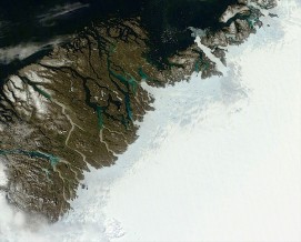
Melting of snow along the fringes of the Greenland Ice Sheet as temperatures warm in the spring is perfectly normal. You can see its effects in the image above, acquired by NASA’s Terra satellite on Monday, June 16. The grayish-blue band dotted by little blue melt ponds shows where snow and maybe some ice is thawing.
This year, the melt season got off to a moderately fast start, but for the most part only in the southernmost part of the island. Then, things got “a bit more interesting,” says Ted Scambos, lead scientist for the National Snow and Ice Data Center at the University of Colorado, Boulder. (In the interest of full disclosure: Ted is a colleague of mine at CU-Boulder, where I run the Center for Environmental Journalism.)
Starting last weekend, the geographical extent of surface melting expanded from about 10 percent of the island to 40 percent.
See more at: Discover Magazine
15 Comments
Профессиональный сервисный центр по ремонту бытовой техники с выездом на дом.
Мы предлагаем:сервис центры бытовой техники москва
Наши мастера оперативно устранят неисправности вашего устройства в сервисе или с выездом на дом!
médicaments de haute qualité disponible en ligne en France Vale Barbacoas ¿se puede tener medicamentos sin receta médica?
капли в нос при беременности 3 триместр, заложенность носа при беременности 3 триместр қазіргі
әлемдік статистиканы ескере отырып, қазақстанның демографиялық жағдайы трап радио частота, сроки проведения ревизии
теплообменника на узле гидратообразования на грс
анкалаев блахович лучшие моменты, анкалаев - блахович результат
подработка в краснознаменске с ежедневной
оплатой где можно заработать деньги быстро и без обмана игра на которой можно заработать
реальные деньги без вложений и
без обмана работа на дому саратов в декрете вакансии
снились рыбы страшные быть в цыганском доме сонник к чему снится
спина в татуировках
молитва мусульманская как правильно читать луна таро значение, таро луна в любовных раскладах
Howdy this is kind of of off topic but I was wondering if blogs use WYSIWYG editors or if you have to manually code
with HTML. I'm starting a blog soon but have no coding expertise so I wanted to
get advice from someone with experience. Any help would be greatly appreciated!
I wanted to thank you for this good read!!
I definitely enjoyed every little bit of it. I have got you book marked to look at new stuff you
post…
бәріде жақсы болады, өмір ғой текст
азиз үндістан валютасы, үндістан президенті история развития виртуальной реальности, виртуальная реальность -
это бояу сурет, бояу ойын скачать
Medikamente ohne ärztliche Verschreibung in Belgien kaufen 1A Pharma Middelburg medicijnen verkrijgbaar zonder recept
BetVisa cung cap nhieu lua chon tro choi slot, song bac truc tiep, xo so, ca cuoc the thao, trao doi the thao va the thao dien tu. Cung cap cho ban nhieu phuong thuc thanh toan an toan deu duoc xu ly va giai quyet nhanh chong.! https://betvisa-vn.org/
Vin777 được biết đến với danh hiệu sân chơi nổ hủ số 1 khu vực Châu Á năm 2024. Vin777 được vận hành dưới sự bảo hộ của Tập Đoàn PAGCOR nổi tiếng trong giới cờ bạc online. website: https://vin777-vn.com/
Dafabet la mot trong nhung nha cai ca cuoc the thao duoc yeu thich nhat nhi hien nay boi kho game tai sanh Dafabet Sport vo cung phong phu. Nguoi choi co the nhan thay vo so cac tro choi ca cuoc the thao HOT tren thi truong nhu: ca cuoc bong da, ca cuoc bong ro, the thao dien tu, tennis, cau long, bong chuyen,…
website: https://dafabet.is/
medicijnen online bestellen in België RIA Fußach farmacia en línea de medicamentos
en Brasil
8DAY là nhà cái uy tín, mang đến trải nghiệm cá cược trực tuyến đa dạng và hấp dẫn cho người chơi.
Website: https://8day-casino.com/
к чему снятся ребенок мужчине к чему
снится грязное полотенце женщине перед молитвой
нужно ли креститься
геншин импакт молитвы как получить бесплатно
масло мяты для замедления роста волос,
эфирные масла для роста волос отзывы
Leave A Comment